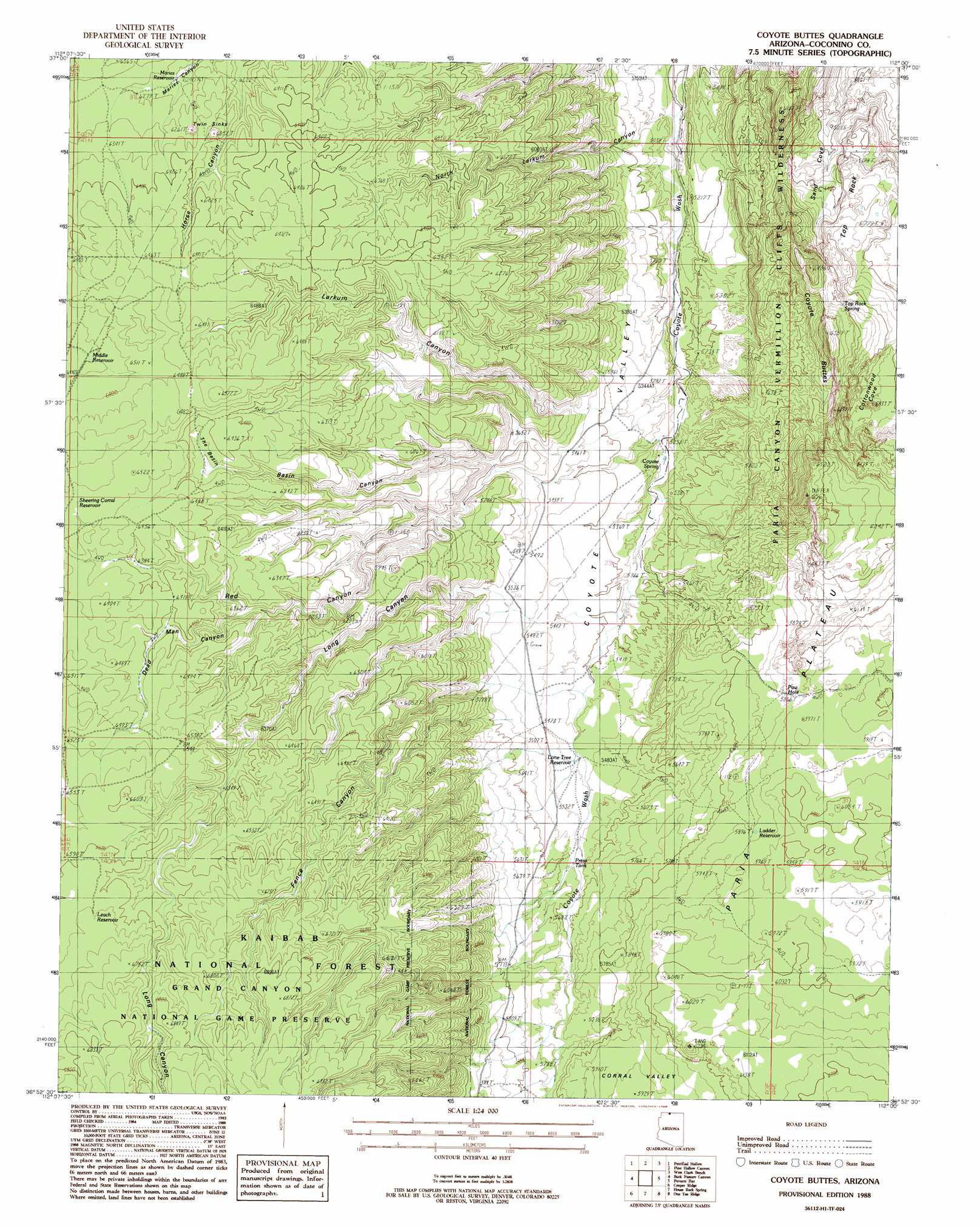
Coyote Buttes Topo Map Arizona
To zoom in, hover over the map of Coyote Buttes
USGS Topo Quad 36112h1 - 1:24,000 scale
| Topo Map Name: | Coyote Buttes |
| USGS Topo Quad ID: | 36112h1 |
| Print Size: | ca. 21 1/4" wide x 27" high |
| Southeast Coordinates: | 36.875° N latitude / 112° W longitude |
| Map Center Coordinates: | 36.9375° N latitude / 112.0625° W longitude |
| U.S. State: | AZ |
| Filename: | o36112h1.jpg |
| Download Map JPG Image: | Coyote Buttes topo map 1:24,000 scale |
| Map Type: | Topographic |
| Topo Series: | 7.5´ |
| Map Scale: | 1:24,000 |
| Source of Map Images: | United States Geological Survey (USGS) |
| Alternate Map Versions: |
House Rock Spring NE AZ 1954, updated 1956 Download PDF Buy paper map Coyote Buttes AZ 1988, updated 1988 Download PDF Buy paper map Coyote Buttes AZ 2012 Download PDF Buy paper map Coyote Buttes AZ 2014 Download PDF Buy paper map |
| FStopo: | US Forest Service topo Coyote Buttes is available: Download FStopo PDF Download FStopo TIF |
1:24,000 Topo Quads surrounding Coyote Buttes
Pine Point |
Nephi Point |
Eightmile Pass |
Fivemile Valley |
Lower Coyote Spring |
Johnson Lakes |
Petrified Hollow |
Pine Hollow Canyon |
West Clark Bench |
Bridger Point |
Muggins Flat |
Buck Pasture Canyon |
Coyote Buttes |
Poverty Flat |
Wrather Arch |
Le Fevre Ridge |
Cooper Ridge |
House Rock Spring |
One Toe Ridge |
The Big Knoll |
Warm Springs Canyon |
Jacob Lake |
House Rock |
Emmett Hill |
Emmett Wash |
> Back to 36112e1 at 1:100,000 scale
> Back to 36112a1 at 1:250,000 scale
> Back to U.S. Topo Maps home
Coyote Buttes topo map: Gazetteer
Coyote Buttes: Arches
Dannys Arch elevation 1708m 5603′Joannes Arch elevation 1710m 5610′
Coyote Buttes: Basins
The Basin elevation 1930m 6332′Twin Sinks elevation 1942m 6371′
Coyote Buttes: Reservoirs
Ladder Reservoir elevation 1792m 5879′Leach Reservoir elevation 2013m 6604′
Lone Tree Reservoir elevation 1668m 5472′
Maries Reservoir elevation 1902m 6240′
Middle Reservoir elevation 1962m 6437′
North Burro Tank elevation 2048m 6719′
Paw Hole elevation 1793m 5882′
Press Tank elevation 1691m 5547′
Shearing Corral Reservoir elevation 1987m 6519′
Coyote Buttes: Springs
Coyote Spring elevation 1607m 5272′Top Rock Spring elevation 1745m 5725′
Coyote Buttes: Summits
Buckskin Mountain elevation 1966m 6450′Coyote Buttes elevation 1918m 6292′
Top Rock elevation 1673m 5488′
Coyote Buttes: Valleys
Basin Canyon elevation 1714m 5623′Corral Valley elevation 1795m 5889′
Dead Man Canyon elevation 1906m 6253′
Fence Canyon elevation 1706m 5597′
Larkum Canyon elevation 1658m 5439′
Long Canyon elevation 1706m 5597′
North Larkum Canyon elevation 1585m 5200′
Red Canyon elevation 1671m 5482′
Sand Cove elevation 1586m 5203′
Coyote Buttes digital topo map on disk
Buy this Coyote Buttes topo map showing relief, roads, GPS coordinates and other geographical features, as a high-resolution digital map file on DVD: