Vogelsang Peak Topo Map California
To zoom in, hover over the map of Vogelsang Peak
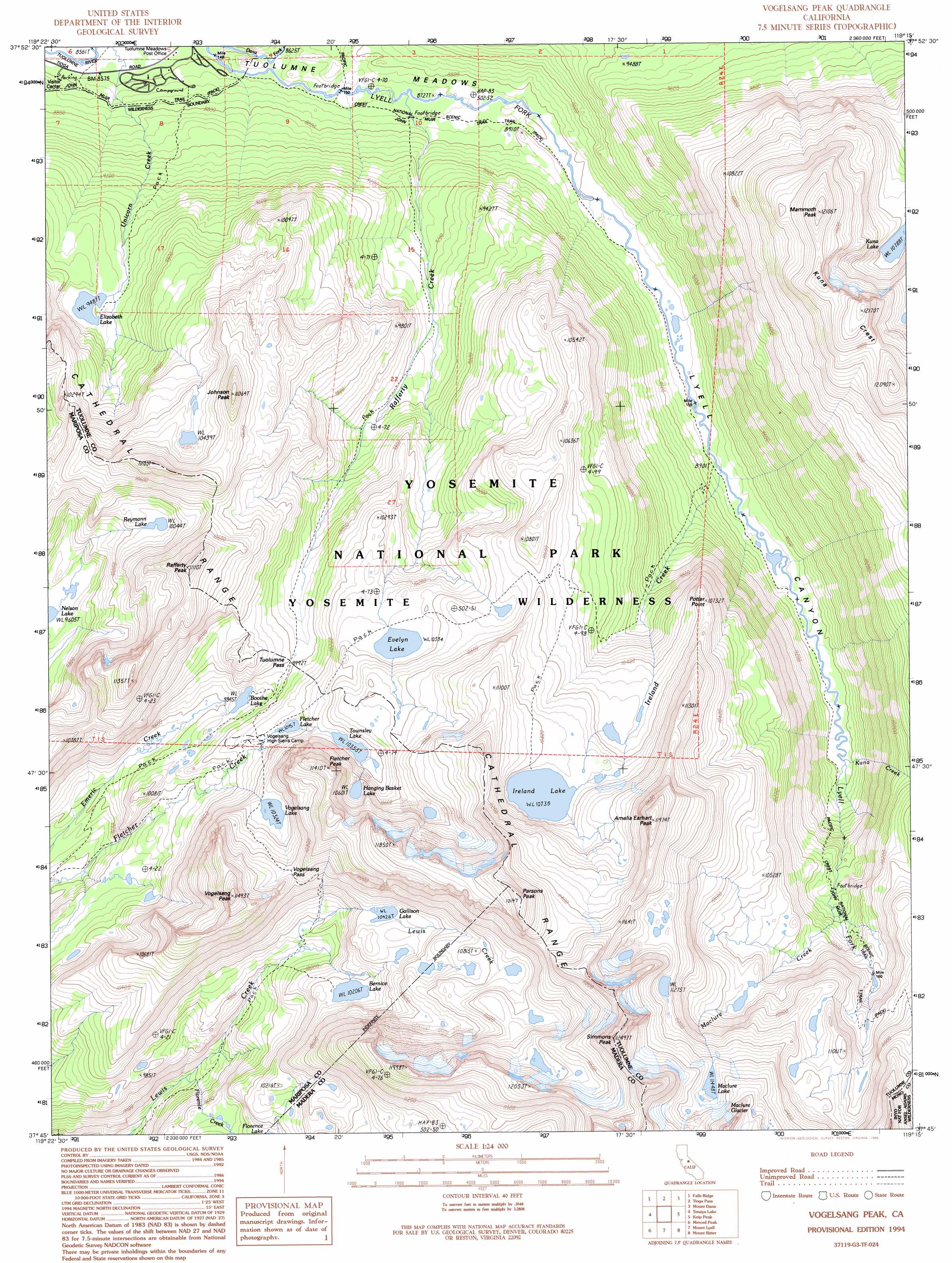
USGS Topo Quad 37119g3 - 1:24,000 scale
| Topo Map Name: | Vogelsang Peak |
| USGS Topo Quad ID: | 37119g3 |
| Print Size: | ca. 21 1/4" wide x 27" high |
| Southeast Coordinates: | 37.75° N latitude / 119.25° W longitude |
| Map Center Coordinates: | 37.8125° N latitude / 119.3125° W longitude |
| U.S. State: | CA |
| Filename: | o37119g3.jpg |
| Download Map JPG Image: | Vogelsang Peak topo map 1:24,000 scale |
| Map Type: | Topographic |
| Topo Series: | 7.5´ |
| Map Scale: | 1:24,000 |
| Source of Map Images: | United States Geological Survey (USGS) |
| Alternate Map Versions: |
Vogelsang Peak CA 1990, updated 1990 Download PDF Buy paper map Vogelsang Peak CA 1994, updated 1995 Download PDF Buy paper map Vogelsang Peak CA 1994, updated 1997 Download PDF Buy paper map Vogelsang Peak CA 2012 Download PDF Buy paper map Vogelsang Peak CA 2015 Download PDF Buy paper map |
| FStopo: | US Forest Service topo Vogelsang Peak is available: Download FStopo PDF Download FStopo TIF |
1:24,000 Topo Quads surrounding Vogelsang Peak
Piute Mountain |
Matterhorn Peak |
Dunderberg Peak |
Lundy |
Negit Island |
Ten Lakes |
Falls Ridge |
Tioga Pass |
Mount Dana |
Lee Vining |
Yosemite Falls |
Tenaya Lake |
Vogelsang Peak |
Koip Peak |
June Lake |
Half Dome |
Merced Peak |
Mount Lyell |
Mount Ritter |
Mammoth Mountain |
Mariposa Grove |
Sing Peak |
Timber Knob |
Cattle Mountain |
Crystal Crag |
> Back to 37119e1 at 1:100,000 scale
> Back to 37118a1 at 1:250,000 scale
> Back to U.S. Topo Maps home
Vogelsang Peak topo map: Gazetteer
Vogelsang Peak: Gaps
Tuolumne Pass elevation 3047m 9996′Vogelsang Pass elevation 3255m 10679′
Vogelsang Peak: Lakes
Bernice Lake elevation 3115m 10219′Boothe Lake elevation 3014m 9888′
Elizabeth Lake elevation 2897m 9504′
Evelyn Lake elevation 3151m 10337′
Fletcher Lake elevation 3112m 10209′
Florence Lake elevation 3014m 9888′
Gallison Lake elevation 3179m 10429′
Hanging Basket Lake elevation 3240m 10629′
Ireland Lake elevation 3274m 10741′
Kuna Lake elevation 3291m 10797′
Maclure Lake elevation 3496m 11469′
Reymann Lake elevation 3069m 10068′
Townsley Lake elevation 3153m 10344′
Upper Fletcher Lake elevation 3153m 10344′
Vogelsang Lake elevation 3152m 10341′
Vogelsang Peak: Streams
Florence Creek elevation 2790m 9153′Ireland Creek elevation 2709m 8887′
Kuna Creek elevation 2740m 8989′
Maclure Creek elevation 2966m 9730′
Rafferty Creek elevation 2652m 8700′
Unicorn Creek elevation 2612m 8569′
Vogelsang Peak: Summits
Amelia Earhart Peak elevation 3648m 11968′Fletcher Peak elevation 3477m 11407′
Johnson Peak elevation 3369m 11053′
Mammoth Peak elevation 3685m 12089′
Parsons Peak elevation 3699m 12135′
Potter Point elevation 3253m 10672′
Rafferty Peak elevation 3382m 11095′
Simmons Peak elevation 3789m 12431′
Vogelsang Peak elevation 3488m 11443′
Vogelsang Peak: Valleys
Lyell Canyon elevation 2676m 8779′Vogelsang Peak digital topo map on disk
Buy this Vogelsang Peak topo map showing relief, roads, GPS coordinates and other geographical features, as a high-resolution digital map file on DVD: