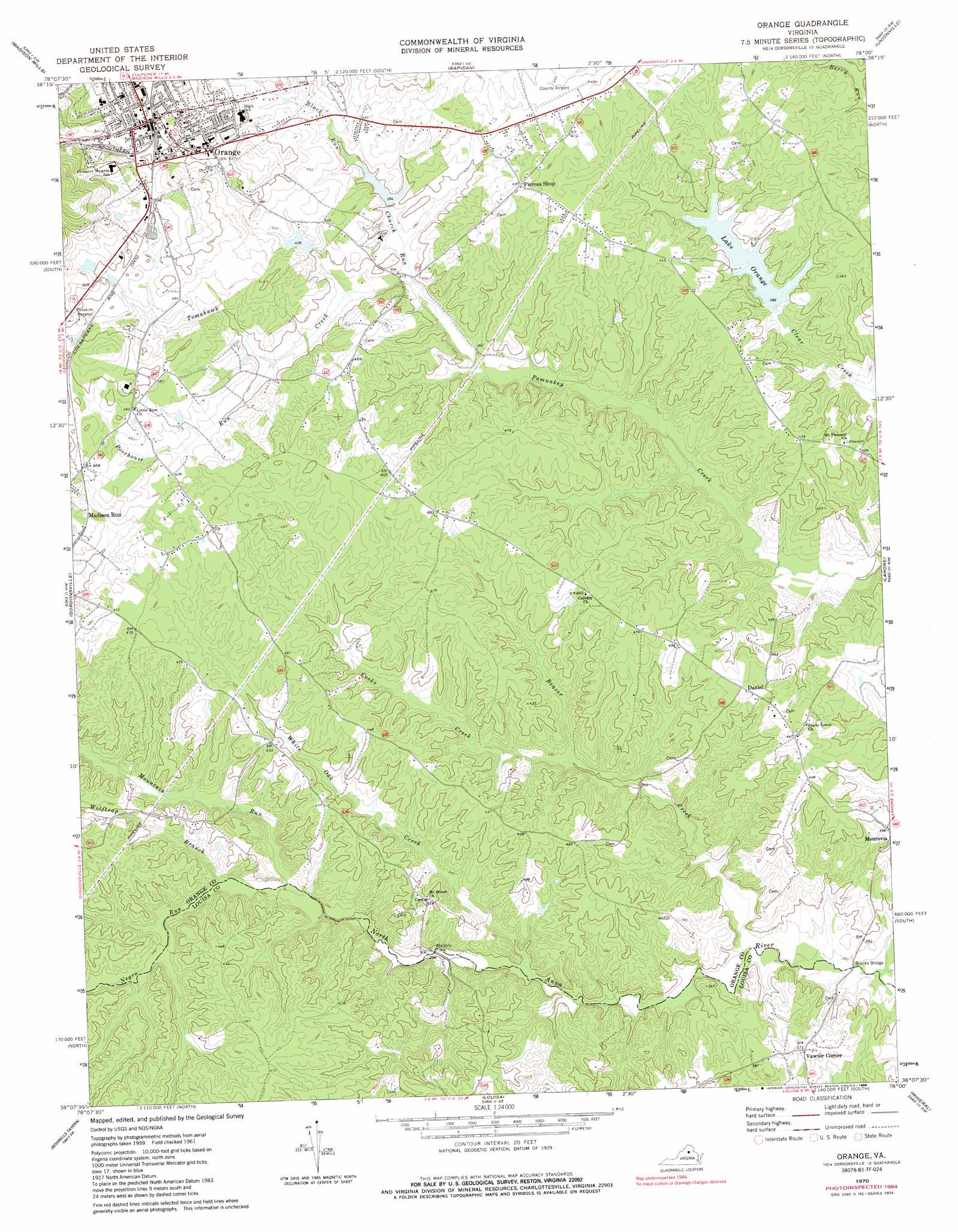
Orange Topo Map Virginia
To zoom in, hover over the map of Orange
USGS Topo Quad 38078b1 - 1:24,000 scale
| Topo Map Name: | Orange |
| USGS Topo Quad ID: | 38078b1 |
| Print Size: | ca. 21 1/4" wide x 27" high |
| Southeast Coordinates: | 38.125° N latitude / 78° W longitude |
| Map Center Coordinates: | 38.1875° N latitude / 78.0625° W longitude |
| U.S. State: | VA |
| Filename: | o38078b1.jpg |
| Download Map JPG Image: | Orange topo map 1:24,000 scale |
| Map Type: | Topographic |
| Topo Series: | 7.5´ |
| Map Scale: | 1:24,000 |
| Source of Map Images: | United States Geological Survey (USGS) |
| Alternate Map Versions: |
Orange VA 1970, updated 1972 Download PDF Buy paper map Orange VA 1970, updated 1980 Download PDF Buy paper map Orange VA 1970, updated 1984 Download PDF Buy paper map Orange VA 1994, updated 1997 Download PDF Buy paper map Orange VA 2010 Download PDF Buy paper map Orange VA 2013 Download PDF Buy paper map Orange VA 2016 Download PDF Buy paper map |
1:24,000 Topo Quads surrounding Orange
Madison |
Brightwood |
Culpeper West |
Culpeper East |
Germanna Bridge |
Rochelle |
Madison Mills |
Rapidan |
Unionville |
Mine Run |
Barboursville |
Gordonsville |
Orange |
Lahore |
Belmont |
Keswick |
Boswells Tavern |
Louisa |
Mineral |
Lake Anna West |
Boyd Tavern |
Zion Crossroads |
Ferncliff |
Pendleton |
Buckner |
> Back to 38078a1 at 1:100,000 scale
> Back to 38078a1 at 1:250,000 scale
> Back to U.S. Topo Maps home
Orange topo map: Gazetteer
Orange: Airports
Orange County Airport elevation 136m 446′Orange: Bridges
Brocks Bridge elevation 77m 252′Orange: Dams
Clear Creek Dam elevation 115m 377′J E Taylor Dam elevation 131m 429′
Taylors Dam elevation 115m 377′
Orange: Populated Places
Daniel elevation 136m 446′Orange elevation 159m 521′
Vawter Corner elevation 110m 360′
Orange: Post Offices
Orange Post Office elevation 165m 541′Orange: Reservoirs
J E Taylor Lake elevation 131m 429′Lake Orange elevation 117m 383′
Taylors Pond elevation 115m 377′
Orange: Streams
Beaver Creek elevation 82m 269′Black Run elevation 122m 400′
Church Run elevation 109m 357′
Cooks Creek elevation 92m 301′
Mountain Run elevation 92m 301′
Negro Run elevation 93m 305′
Poorhouse Run elevation 115m 377′
Tomahawk Creek elevation 109m 357′
White Oak Creek elevation 85m 278′
Wolftrap Branch elevation 94m 308′
Orange digital topo map on disk
Buy this Orange topo map showing relief, roads, GPS coordinates and other geographical features, as a high-resolution digital map file on DVD:
Western Virginia & Southern West Virginia
Buy digital topo maps: Western Virginia & Southern West Virginia