Rochelle Topo Map Virginia
To zoom in, hover over the map of Rochelle
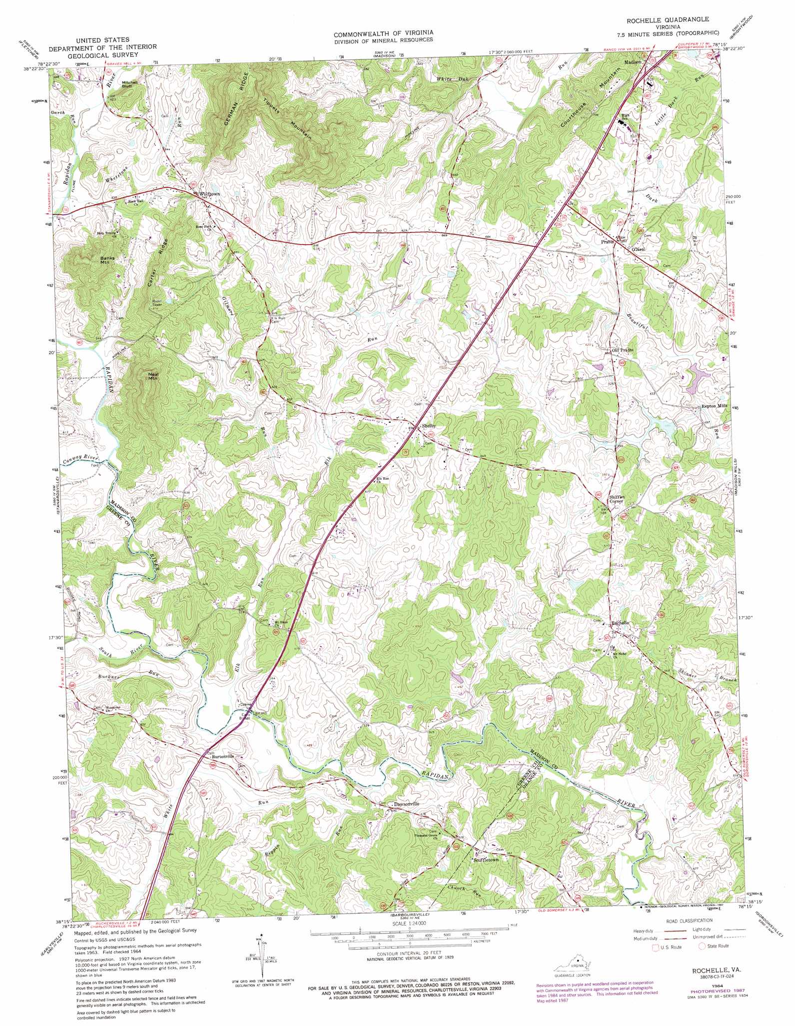
USGS Topo Quad 38078c3 - 1:24,000 scale
| Topo Map Name: | Rochelle |
| USGS Topo Quad ID: | 38078c3 |
| Print Size: | ca. 21 1/4" wide x 27" high |
| Southeast Coordinates: | 38.25° N latitude / 78.25° W longitude |
| Map Center Coordinates: | 38.3125° N latitude / 78.3125° W longitude |
| U.S. State: | VA |
| Filename: | o38078c3.jpg |
| Download Map JPG Image: | Rochelle topo map 1:24,000 scale |
| Map Type: | Topographic |
| Topo Series: | 7.5´ |
| Map Scale: | 1:24,000 |
| Source of Map Images: | United States Geological Survey (USGS) |
| Alternate Map Versions: |
Rochelle VA 1964, updated 1966 Download PDF Buy paper map Rochelle VA 1964, updated 1973 Download PDF Buy paper map Rochelle VA 1964, updated 1987 Download PDF Buy paper map Rochelle VA 1964, updated 1987 Download PDF Buy paper map Rochelle VA 1977, updated 1981 Download PDF Buy paper map Rochelle VA 2010 Download PDF Buy paper map Rochelle VA 2013 Download PDF Buy paper map Rochelle VA 2016 Download PDF Buy paper map |
1:24,000 Topo Quads surrounding Rochelle
Stanley |
Big Meadows |
Old Rag Mountain |
Woodville |
Castleton |
Elkton East |
Fletcher |
Madison |
Brightwood |
Culpeper West |
Swift Run Gap |
Stanardsville |
Rochelle |
Madison Mills |
Rapidan |
Free Union |
Earlysville |
Barboursville |
Gordonsville |
Orange |
Charlottesville West |
Charlottesville East |
Keswick |
Boswells Tavern |
Louisa |
> Back to 38078a1 at 1:100,000 scale
> Back to 38078a1 at 1:250,000 scale
> Back to U.S. Topo Maps home
Rochelle topo map: Gazetteer
Rochelle: Bridges
Early Bridge elevation 135m 442′Rochelle: Cliffs
Mitchell Bluff elevation 220m 721′Rochelle: Crossings
Wilhoits Ford elevation 140m 459′Rochelle: Dams
Beautiful Run Number 1b Dam elevation 163m 534′Beautiful Run Number 2a Dam elevation 152m 498′
Rochelle: Flats
John Lambs Bottom elevation 149m 488′Rochelle: Populated Places
Burtonville elevation 160m 524′Dawsonville elevation 151m 495′
O'Neal elevation 187m 613′
Pratts elevation 179m 587′
Repton Mills elevation 137m 449′
Rochelle elevation 182m 597′
Scuffletown elevation 174m 570′
Shelby elevation 200m 656′
Shifflet Corner elevation 177m 580′
Wilhoit (historical) elevation 137m 449′
Wolftown elevation 228m 748′
Rochelle: Post Offices
Dawsonville Post Office (historical) elevation 141m 462′Erald Post Office (historical) elevation 170m 557′
Rosebrook Post Office (historical) elevation 156m 511′
Rochelle: Ridges
Carter Ridge elevation 258m 846′Courthouse Mountain elevation 201m 659′
Tippets Mountain elevation 355m 1164′
Rochelle: Streams
Buckner Run elevation 136m 446′Conway River elevation 151m 495′
Elk Run elevation 136m 446′
Garth Run elevation 182m 597′
Gilmore Run elevation 148m 485′
Rippin Run elevation 131m 429′
South River elevation 140m 459′
Whetstone Run elevation 176m 577′
White Run elevation 132m 433′
Rochelle: Summits
Banks Mountain elevation 301m 987′Neal Mountain elevation 337m 1105′
Rochelle digital topo map on disk
Buy this Rochelle topo map showing relief, roads, GPS coordinates and other geographical features, as a high-resolution digital map file on DVD:
Western Virginia & Southern West Virginia
Buy digital topo maps: Western Virginia & Southern West Virginia