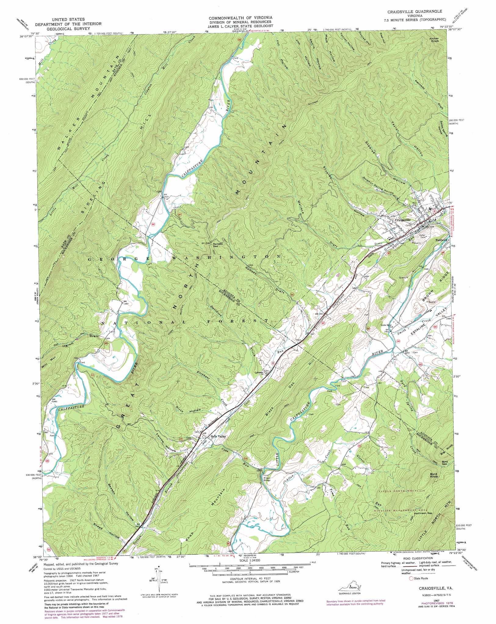
Craigsville Topo Map Virginia
To zoom in, hover over the map of Craigsville
USGS Topo Quad 38079a4 - 1:24,000 scale
| Topo Map Name: | Craigsville |
| USGS Topo Quad ID: | 38079a4 |
| Print Size: | ca. 21 1/4" wide x 27" high |
| Southeast Coordinates: | 38° N latitude / 79.375° W longitude |
| Map Center Coordinates: | 38.0625° N latitude / 79.4375° W longitude |
| U.S. State: | VA |
| Filename: | o38079a4.jpg |
| Download Map JPG Image: | Craigsville topo map 1:24,000 scale |
| Map Type: | Topographic |
| Topo Series: | 7.5´ |
| Map Scale: | 1:24,000 |
| Source of Map Images: | United States Geological Survey (USGS) |
| Alternate Map Versions: |
Craigsville VA 1967, updated 1969 Download PDF Buy paper map Craigsville VA 1967, updated 1978 Download PDF Buy paper map Craigsville VA 2011 Download PDF Buy paper map Craigsville VA 2013 Download PDF Buy paper map Craigsville VA 2016 Download PDF Buy paper map |
| FStopo: | US Forest Service topo Craigsville is available: Download FStopo PDF Download FStopo TIF |
1:24,000 Topo Quads surrounding Craigsville
Mustoe |
Monterey Se |
Mcdowell |
West Augusta |
Stokesville |
Burnsville |
Williamsville |
Deerfield |
Elliott Knob |
Churchville |
Bath Alum |
Green Valley |
Craigsville |
Augusta Springs |
Greenville |
Nimrod Hall |
Millboro |
Goshen |
Brownsburg |
Vesuvius |
Longdale Furnace |
Collierstown |
Lexington |
Cornwall |
Montebello |
> Back to 38079a1 at 1:100,000 scale
> Back to 38078a1 at 1:250,000 scale
> Back to U.S. Topo Maps home
Craigsville topo map: Gazetteer
Craigsville: Bridges
Wilson Bridge elevation 438m 1437′Craigsville: Gaps
Byrd Gap elevation 675m 2214′Halfmoon Gap elevation 925m 3034′
Ramsey Gap elevation 661m 2168′
Craigsville: Populated Places
Bells Valley elevation 461m 1512′Craigsville elevation 466m 1528′
Craigsville: Post Offices
Craigsville Post Office elevation 470m 1541′Craigsville: Streams
Allen Creek elevation 426m 1397′Byrd Spring Creek elevation 444m 1456′
Cove Run elevation 423m 1387′
Davidson Creek elevation 460m 1509′
Elephant Creek elevation 457m 1499′
Glover Run elevation 450m 1476′
Grassy Run elevation 456m 1496′
Smith Creek elevation 447m 1466′
Toma Run elevation 431m 1414′
Craigsville: Summits
Archer Knob elevation 1039m 3408′Black Oak Hill elevation 637m 2089′
Byrd Knob elevation 842m 2762′
Sideling Hill elevation 943m 3093′
Craigsville: Trails
North Mountain Trail elevation 718m 2355′Walker Mountain Trail elevation 944m 3097′
Craigsville: Valleys
Beason Hollow elevation 445m 1459′Estaline Valley elevation 443m 1453′
Farrow Hollow elevation 459m 1505′
Ingram Draft elevation 447m 1466′
Kirtz Hollow elevation 458m 1502′
Ramsey Draft elevation 477m 1564′
Snead Hollow elevation 441m 1446′
Staples Hollow elevation 489m 1604′
Stuples Hollow elevation 474m 1555′
Sulphur Spring Hollow elevation 469m 1538′
Taylor Hollow elevation 461m 1512′
Wallace Draft elevation 475m 1558′
Craigsville digital topo map on disk
Buy this Craigsville topo map showing relief, roads, GPS coordinates and other geographical features, as a high-resolution digital map file on DVD:
Western Virginia & Southern West Virginia
Buy digital topo maps: Western Virginia & Southern West Virginia