Lexington Topo Map Virginia
To zoom in, hover over the map of Lexington
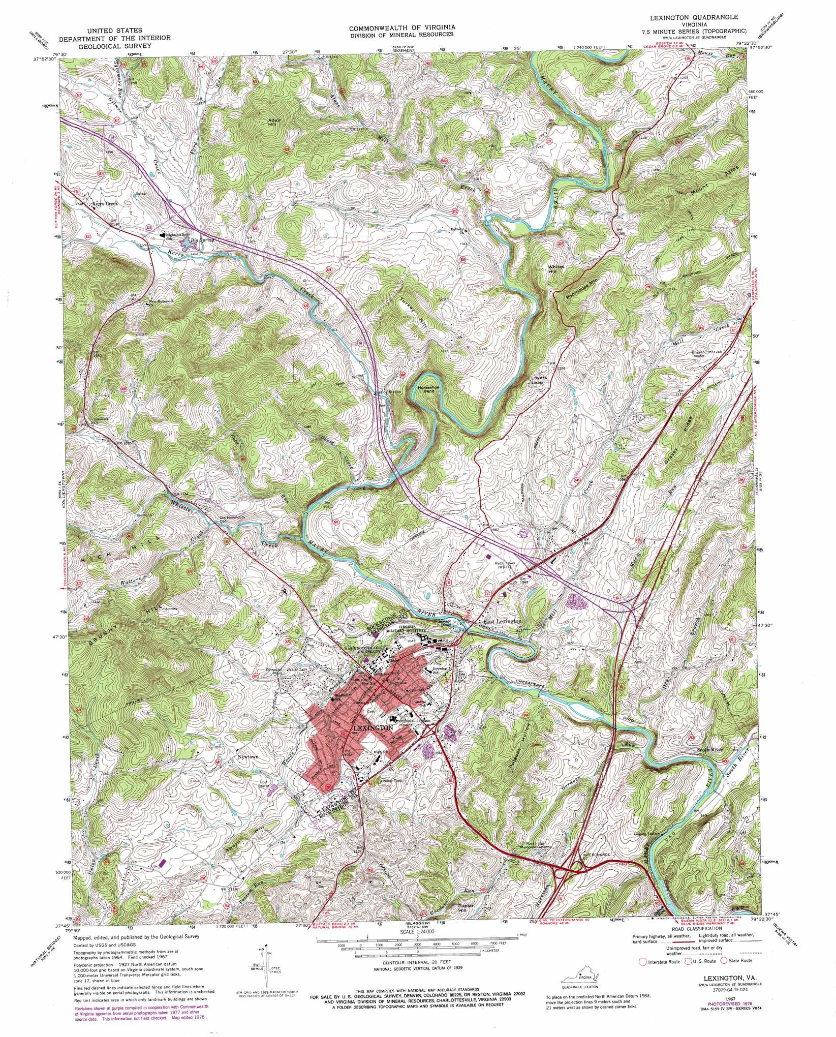
USGS Topo Quad 37079g4 - 1:24,000 scale
| Topo Map Name: | Lexington |
| USGS Topo Quad ID: | 37079g4 |
| Print Size: | ca. 21 1/4" wide x 27" high |
| Southeast Coordinates: | 37.75° N latitude / 79.375° W longitude |
| Map Center Coordinates: | 37.8125° N latitude / 79.4375° W longitude |
| U.S. State: | VA |
| Filename: | o37079g4.jpg |
| Download Map JPG Image: | Lexington topo map 1:24,000 scale |
| Map Type: | Topographic |
| Topo Series: | 7.5´ |
| Map Scale: | 1:24,000 |
| Source of Map Images: | United States Geological Survey (USGS) |
| Alternate Map Versions: |
Lexington VA 1967, updated 1969 Download PDF Buy paper map Lexington VA 1967, updated 1978 Download PDF Buy paper map Lexington VA 1967, updated 1989 Download PDF Buy paper map Lexington VA 1967, updated 1989 Download PDF Buy paper map Lexington VA 1977, updated 1983 Download PDF Buy paper map Lexington VA 1999, updated 2000 Download PDF Buy paper map Lexington VA 2010 Download PDF Buy paper map Lexington VA 2013 Download PDF Buy paper map Lexington VA 2016 Download PDF Buy paper map |
1:24,000 Topo Quads surrounding Lexington
Bath Alum |
Green Valley |
Craigsville |
Augusta Springs |
Greenville |
Nimrod Hall |
Millboro |
Goshen |
Brownsburg |
Vesuvius |
Longdale Furnace |
Collierstown |
Lexington |
Cornwall |
Montebello |
Sugarloaf Mountain |
Natural Bridge |
Glasgow |
Buena Vista |
Forks Of Buffalo |
Buchanan |
Arnold Valley |
Snowden |
Big Island |
Tobacco Row Mountain |
> Back to 37079e1 at 1:100,000 scale
> Back to 37078a1 at 1:250,000 scale
> Back to U.S. Topo Maps home
Lexington topo map: Gazetteer
Lexington: Bends
Horseshoe Bend elevation 304m 997′Lexington: Bridges
Limekiln Bridge elevation 279m 915′Lexington: Cliffs
Lovers Leap elevation 429m 1407′Lexington: Crossings
Interchange 188 elevation 326m 1069′Interchange 191 elevation 301m 987′
Interchange 50 elevation 345m 1131′
Interchange 55 elevation 300m 984′
Lexington: Parks
Alumni Field elevation 328m 1076′Alumni Memorial Field elevation 297m 974′
Captain Dick Smith Baseball Field elevation 330m 1082′
Delaney Field elevation 305m 1000′
Hopkins Green elevation 317m 1040′
Lexington Historic District elevation 319m 1046′
Liberty Hall Fields elevation 328m 1076′
Liberty Hall Soccer Fields elevation 327m 1072′
Smith Baseball Field elevation 329m 1079′
Son Read Memorial Track elevation 298m 977′
Virginia Military Institute Historic District elevation 314m 1030′
Washington and Lee University Historic District elevation 322m 1056′
Wilson Field elevation 314m 1030′
Lexington: Populated Places
East Lexington elevation 287m 941′Kerrs Creek elevation 354m 1161′
Lexington elevation 324m 1062′
Mudtown elevation 348m 1141′
Newtown elevation 353m 1158′
South River elevation 300m 984′
West Lexington elevation 329m 1079′
Lexington: Post Offices
Lexington Post Office elevation 323m 1059′Lexington: Ridges
Grassy Ridge elevation 419m 1374′Lexington: Springs
Big Spring elevation 335m 1099′Lexington: Streams
Alone Mill Creek elevation 291m 954′Cold Run elevation 273m 895′
Dry Branch elevation 268m 879′
Ford Run elevation 341m 1118′
Gilmer Creek elevation 330m 1082′
Gordons Run elevation 267m 875′
Gould Creek elevation 279m 915′
Harrison Run elevation 277m 908′
Kerrs Creek elevation 278m 912′
Mill Creek elevation 274m 898′
Rubush Run elevation 260m 853′
Shake Rag Branch elevation 382m 1253′
South River elevation 261m 856′
Sycamore Run elevation 372m 1220′
Walters Creek elevation 321m 1053′
Warm Run elevation 268m 879′
Whistle Creek elevation 274m 898′
Woods Creek elevation 280m 918′
Lexington: Summits
Adair Hill elevation 520m 1706′Brushy Hill elevation 592m 1942′
Poorhouse Mountain elevation 495m 1624′
Poplar Hill elevation 379m 1243′
Thorn Hill elevation 379m 1243′
Turkey Hill elevation 479m 1571′
Whites Hill elevation 415m 1361′
Lexington: Valleys
Polecat Hollow elevation 266m 872′Lexington digital topo map on disk
Buy this Lexington topo map showing relief, roads, GPS coordinates and other geographical features, as a high-resolution digital map file on DVD:
Western Virginia & Southern West Virginia
Buy digital topo maps: Western Virginia & Southern West Virginia