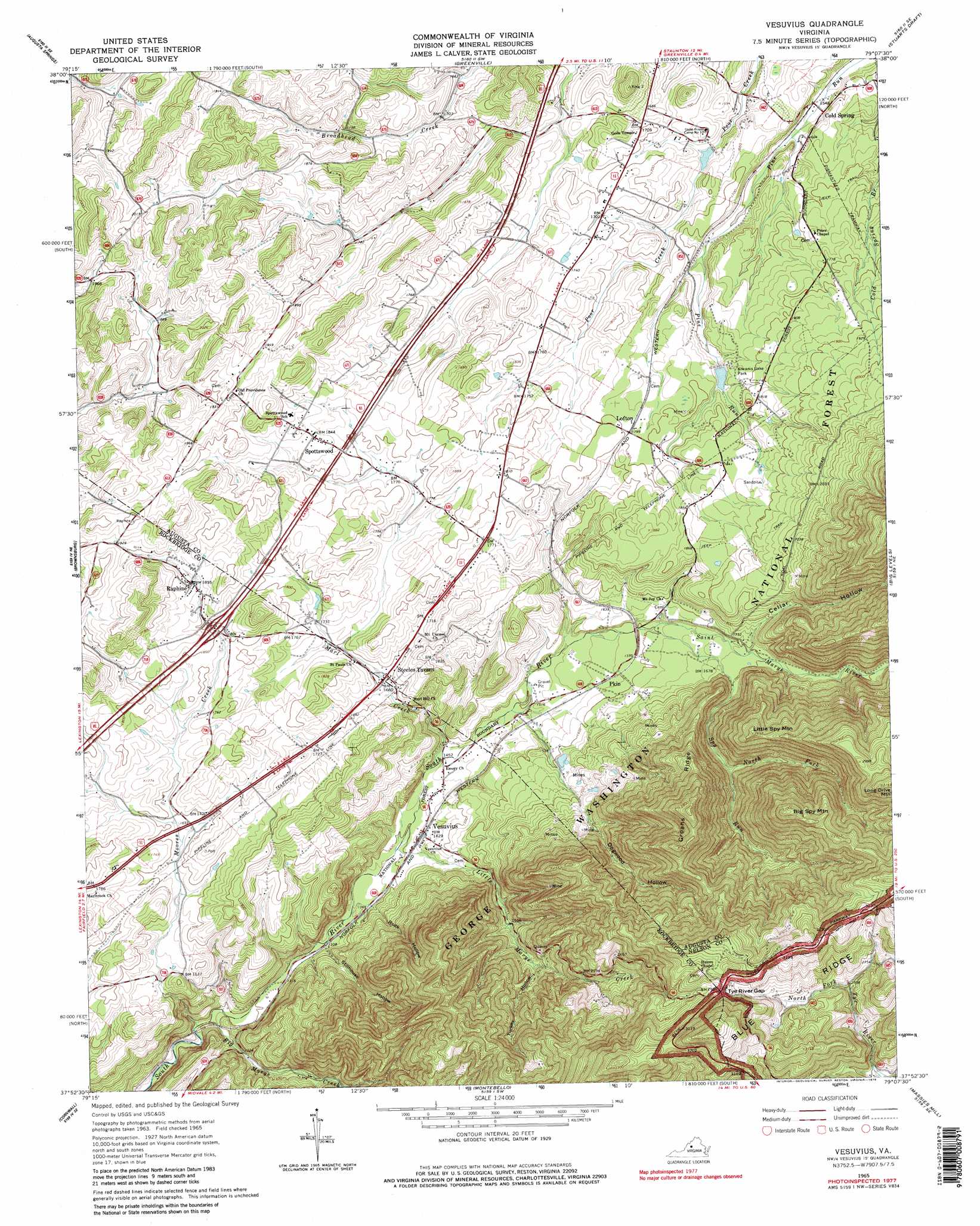
Vesuvius Topo Map Virginia
To zoom in, hover over the map of Vesuvius
USGS Topo Quad 37079h2 - 1:24,000 scale
| Topo Map Name: | Vesuvius |
| USGS Topo Quad ID: | 37079h2 |
| Print Size: | ca. 21 1/4" wide x 27" high |
| Southeast Coordinates: | 37.875° N latitude / 79.125° W longitude |
| Map Center Coordinates: | 37.9375° N latitude / 79.1875° W longitude |
| U.S. State: | VA |
| Filename: | o37079h2.jpg |
| Download Map JPG Image: | Vesuvius topo map 1:24,000 scale |
| Map Type: | Topographic |
| Topo Series: | 7.5´ |
| Map Scale: | 1:24,000 |
| Source of Map Images: | United States Geological Survey (USGS) |
| Alternate Map Versions: |
Vesuvius VA 1965, updated 1967 Download PDF Buy paper map Vesuvius VA 1965, updated 1979 Download PDF Buy paper map Vesuvius VA 1965, updated 1979 Download PDF Buy paper map Vesuvius VA 2011 Download PDF Buy paper map Vesuvius VA 2013 Download PDF Buy paper map Vesuvius VA 2016 Download PDF Buy paper map |
| FStopo: | US Forest Service topo Vesuvius is available: Download FStopo PDF Download FStopo TIF |
1:24,000 Topo Quads surrounding Vesuvius
Deerfield |
Elliott Knob |
Churchville |
Staunton |
Fort Defiance |
Craigsville |
Augusta Springs |
Greenville |
Stuarts Draft |
Waynesboro West |
Goshen |
Brownsburg |
Vesuvius |
Big Levels |
Sherando |
Lexington |
Cornwall |
Montebello |
Massies Mill |
Horseshoe Mountain |
Glasgow |
Buena Vista |
Forks Of Buffalo |
Piney River |
Arrington |
> Back to 37079e1 at 1:100,000 scale
> Back to 37078a1 at 1:250,000 scale
> Back to U.S. Topo Maps home
Vesuvius topo map: Gazetteer
Vesuvius: Crossings
Interchange 205 elevation 550m 1804′Vesuvius: Dams
Anders Pond Dam elevation 495m 1624′Koogler Dam elevation 535m 1755′
South River Number Four Dam elevation 525m 1722′
South River Number Three Dam elevation 493m 1617′
Vesuvius: Falls
Glenn Falls elevation 444m 1456′Vesuvius: Gaps
Tye River Gap elevation 903m 2962′Vesuvius: Parks
Kiwanis Lake Park elevation 542m 1778′Tye River Gap Recreational Area elevation 493m 1617′
Vesuvius: Populated Places
Cold Spring elevation 475m 1558′Lofton elevation 548m 1797′
Raphine elevation 564m 1850′
Spottswood elevation 565m 1853′
Steeles Tavern elevation 513m 1683′
Vesuvius elevation 435m 1427′
Wilkie (historical) elevation 851m 2791′
Vesuvius: Reservoirs
Kiwanis Lake elevation 525m 1722′Willow Lake elevation 535m 1755′
Vesuvius: Ridges
Groahs Ridge elevation 867m 2844′Vesuvius: Streams
Big Marys Creek elevation 388m 1272′Little Marys Creek elevation 425m 1394′
Marl Creek elevation 438m 1437′
Moores Creek elevation 388m 1272′
North Fork Spy Run elevation 564m 1850′
Saint Marys River elevation 469m 1538′
Spy Run elevation 487m 1597′
Vesuvius: Summits
Aggies Mountain elevation 1023m 3356′Big Spy Mountain elevation 958m 3143′
Donald Mountain elevation 792m 2598′
Little Spy Mountain elevation 803m 2634′
Vesuvius: Valleys
Cellar Hollow elevation 516m 1692′Dogwood Hollow elevation 455m 1492′
Rock Hollow elevation 414m 1358′
Stillhouse Hollow elevation 408m 1338′
Turkey Hollow elevation 536m 1758′
Vesuvius digital topo map on disk
Buy this Vesuvius topo map showing relief, roads, GPS coordinates and other geographical features, as a high-resolution digital map file on DVD:
Western Virginia & Southern West Virginia
Buy digital topo maps: Western Virginia & Southern West Virginia