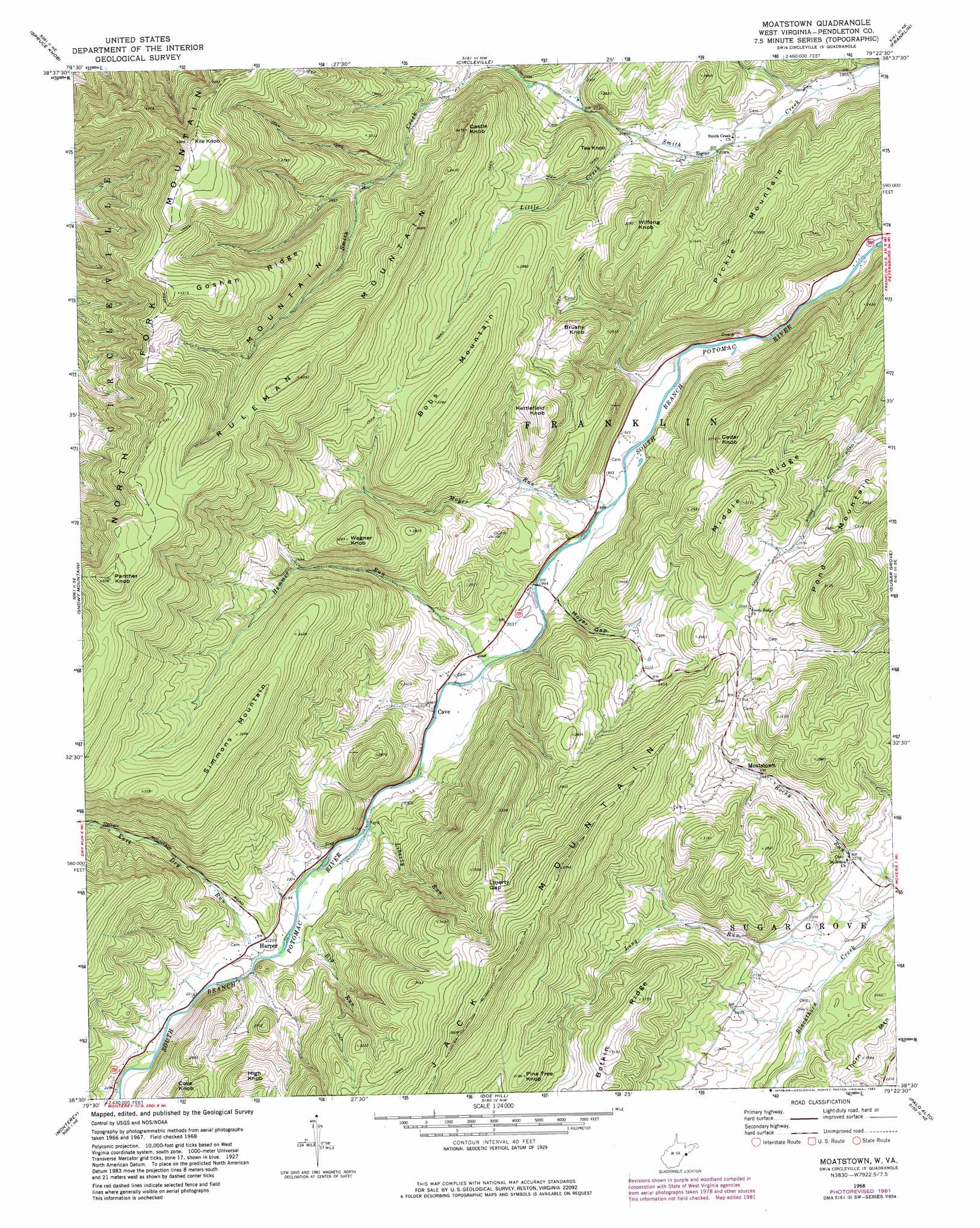
Moatstown Topo Map West Virginia
To zoom in, hover over the map of Moatstown
USGS Topo Quad 38079e4 - 1:24,000 scale
| Topo Map Name: | Moatstown |
| USGS Topo Quad ID: | 38079e4 |
| Print Size: | ca. 21 1/4" wide x 27" high |
| Southeast Coordinates: | 38.5° N latitude / 79.375° W longitude |
| Map Center Coordinates: | 38.5625° N latitude / 79.4375° W longitude |
| U.S. State: | WV |
| Filename: | o38079e4.jpg |
| Download Map JPG Image: | Moatstown topo map 1:24,000 scale |
| Map Type: | Topographic |
| Topo Series: | 7.5´ |
| Map Scale: | 1:24,000 |
| Source of Map Images: | United States Geological Survey (USGS) |
| Alternate Map Versions: |
Moatstown WV 1968, updated 1973 Download PDF Buy paper map Moatstown WV 1968, updated 1982 Download PDF Buy paper map Moatstown WV 2011 Download PDF Buy paper map Moatstown WV 2014 Download PDF Buy paper map Moatstown WV 2016 Download PDF Buy paper map |
| FStopo: | US Forest Service topo Moatstown is available: Download FStopo PDF Download FStopo TIF |
1:24,000 Topo Quads surrounding Moatstown
Glady |
Whitmer |
Onego |
Upper Tract |
Mozer |
Sinks Of Gandy |
Spruce Knob |
Circleville |
Franklin |
Fort Seybert |
Thornwood |
Snowy Mountain |
Moatstown |
Sugar Grove |
Brandywine |
Hightown |
Monterey |
Doe Hill |
Palo Alto |
Reddish Knob |
Mustoe |
Monterey Se |
Mcdowell |
West Augusta |
Stokesville |
> Back to 38079e1 at 1:100,000 scale
> Back to 38078a1 at 1:250,000 scale
> Back to U.S. Topo Maps home
Moatstown topo map: Gazetteer
Moatstown: Gaps
Liberty Gap elevation 1003m 3290′Moyer Gap elevation 641m 2103′
Moatstown: Populated Places
Harper elevation 673m 2208′Moatstown elevation 744m 2440′
Zigler elevation 636m 2086′
Moatstown: Ridges
Botkin Ridge elevation 915m 3001′Goshen Ridge elevation 1221m 4005′
Middle Ridge elevation 964m 3162′
Moatstown: Springs
Hammer Run Spring elevation 901m 2956′Moyer Farm Spring elevation 555m 1820′
Moyer Farm Spring elevation 627m 2057′
Moyer Farm Spring elevation 671m 2201′
Rexrode Farm Spring elevation 602m 1975′
Sennett Farm Spring elevation 555m 1820′
Moatstown: Streams
Big Run elevation 659m 2162′East Dry Run elevation 667m 2188′
Gravel Lick Run elevation 735m 2411′
Hammer Run elevation 613m 2011′
Liberty Run elevation 646m 2119′
Little Creek elevation 660m 2165′
Long Run elevation 674m 2211′
Moyer Run elevation 593m 1945′
Moatstown: Summits
Bobs Mountain elevation 999m 3277′Brushy Knob elevation 838m 2749′
Castle Knob elevation 1058m 3471′
Cedar Knob elevation 965m 3166′
Cove Knob elevation 820m 2690′
High Knob elevation 936m 3070′
Kettlefield Knob elevation 899m 2949′
Kile Knob elevation 1395m 4576′
Panther Knob elevation 1371m 4498′
Pickle Mountain elevation 912m 2992′
Pine Tree Knob elevation 961m 3152′
Pond Mountain elevation 955m 3133′
Ruleman Mountain elevation 1233m 4045′
Simmons Mountain elevation 1121m 3677′
Tea Knob elevation 856m 2808′
Wagner Knob elevation 981m 3218′
Wilfong Knob elevation 935m 3067′
Moatstown digital topo map on disk
Buy this Moatstown topo map showing relief, roads, GPS coordinates and other geographical features, as a high-resolution digital map file on DVD:
Western Virginia & Southern West Virginia
Buy digital topo maps: Western Virginia & Southern West Virginia