Doe Hill Topo Map Virginia
To zoom in, hover over the map of Doe Hill
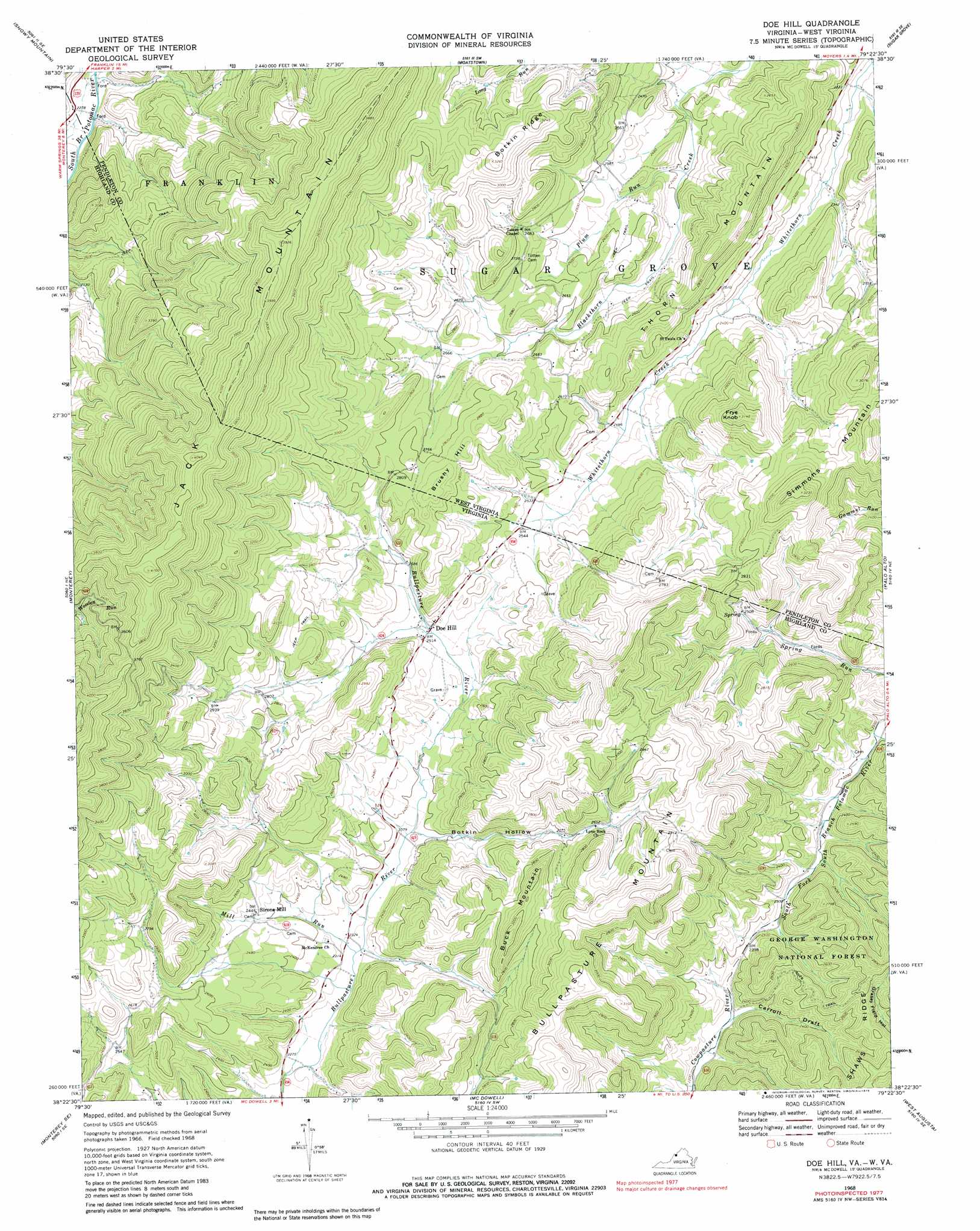
USGS Topo Quad 38079d4 - 1:24,000 scale
| Topo Map Name: | Doe Hill |
| USGS Topo Quad ID: | 38079d4 |
| Print Size: | ca. 21 1/4" wide x 27" high |
| Southeast Coordinates: | 38.375° N latitude / 79.375° W longitude |
| Map Center Coordinates: | 38.4375° N latitude / 79.4375° W longitude |
| U.S. States: | VA, WV |
| Filename: | o38079d4.jpg |
| Download Map JPG Image: | Doe Hill topo map 1:24,000 scale |
| Map Type: | Topographic |
| Topo Series: | 7.5´ |
| Map Scale: | 1:24,000 |
| Source of Map Images: | United States Geological Survey (USGS) |
| Alternate Map Versions: |
Doe Hill VA 1968, updated 1970 Download PDF Buy paper map Doe Hill VA 1968, updated 1979 Download PDF Buy paper map Doe Hill VA 2011 Download PDF Buy paper map Doe Hill VA 2013 Download PDF Buy paper map Doe Hill VA 2016 Download PDF Buy paper map |
| FStopo: | US Forest Service topo Doe Hill is available: Download FStopo PDF Download FStopo TIF |
1:24,000 Topo Quads surrounding Doe Hill
Sinks Of Gandy |
Spruce Knob |
Circleville |
Franklin |
Fort Seybert |
Thornwood |
Snowy Mountain |
Moatstown |
Sugar Grove |
Brandywine |
Hightown |
Monterey |
Doe Hill |
Palo Alto |
Reddish Knob |
Mustoe |
Monterey Se |
Mcdowell |
West Augusta |
Stokesville |
Burnsville |
Williamsville |
Deerfield |
Elliott Knob |
Churchville |
> Back to 38079a1 at 1:100,000 scale
> Back to 38078a1 at 1:250,000 scale
> Back to U.S. Topo Maps home
Doe Hill topo map: Gazetteer
Doe Hill: Populated Places
Doe Hill elevation 765m 2509′Sirons Mill elevation 748m 2454′
Doe Hill: Ridges
Jack Mountain elevation 1194m 3917′Shaws Ridge elevation 847m 2778′
Thorn Mountain elevation 884m 2900′
Doe Hill: Springs
Crummett Spring elevation 745m 2444′Hiner Springs elevation 755m 2477′
Judy Spring elevation 709m 2326′
Sanders Farm Spring elevation 837m 2746′
Doe Hill: Streams
Carroll Draft elevation 688m 2257′Mill Run elevation 702m 2303′
Plum Run elevation 730m 2395′
Whiteman Run elevation 660m 2165′
Doe Hill: Summits
Brushy Hill elevation 893m 2929′Brushy Hill elevation 875m 2870′
Buck Mountain elevation 941m 3087′
Bullpasture Mountain elevation 1001m 3284′
Frye Knob elevation 960m 3149′
Simmons Mountain elevation 983m 3225′
Doe Hill: Trails
Jones Trail elevation 810m 2657′Doe Hill: Valleys
Botkin Hollow elevation 717m 2352′Doe Hill digital topo map on disk
Buy this Doe Hill topo map showing relief, roads, GPS coordinates and other geographical features, as a high-resolution digital map file on DVD:
Western Virginia & Southern West Virginia
Buy digital topo maps: Western Virginia & Southern West Virginia