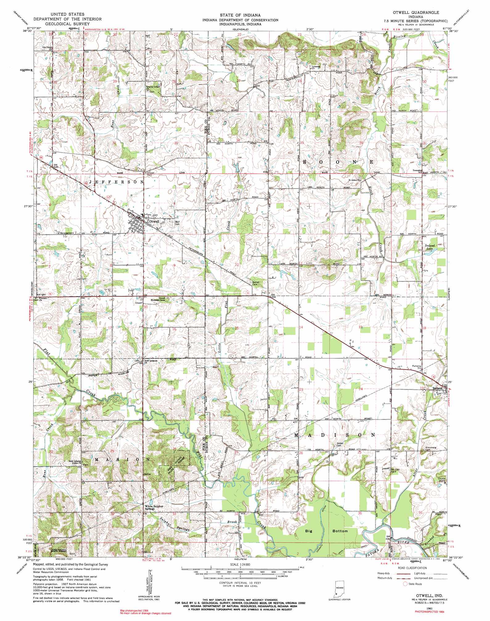
Otwell Topo Map Indiana
To zoom in, hover over the map of Otwell
USGS Topo Quad 38087d1 - 1:24,000 scale
| Topo Map Name: | Otwell |
| USGS Topo Quad ID: | 38087d1 |
| Print Size: | ca. 21 1/4" wide x 27" high |
| Southeast Coordinates: | 38.375° N latitude / 87° W longitude |
| Map Center Coordinates: | 38.4375° N latitude / 87.0625° W longitude |
| U.S. State: | IN |
| Filename: | o38087d1.jpg |
| Download Map JPG Image: | Otwell topo map 1:24,000 scale |
| Map Type: | Topographic |
| Topo Series: | 7.5´ |
| Map Scale: | 1:24,000 |
| Source of Map Images: | United States Geological Survey (USGS) |
| Alternate Map Versions: |
Otwell IN 1961, updated 1962 Download PDF Buy paper map Otwell IN 1961, updated 1962 Download PDF Buy paper map Otwell IN 1961, updated 1962 Download PDF Buy paper map Otwell IN 2010 Download PDF Buy paper map Otwell IN 2013 Download PDF Buy paper map Otwell IN 2016 Download PDF Buy paper map |
1:24,000 Topo Quads surrounding Otwell
Wheatland |
Washington |
Montgomery |
Loogootee |
Shoals |
Monroe City |
Sandy Hook |
Glendale |
Alfordsville |
Rusk |
Petersburg |
Winslow |
Otwell |
Jasper |
Dubois |
Oakland City |
Augusta |
Velpen |
Huntingburg |
Saint Anthony |
Lynnville |
Folsomville |
Holland |
Dale |
Saint Meinrad |
> Back to 38087a1 at 1:100,000 scale
> Back to 38086a1 at 1:250,000 scale
> Back to U.S. Topo Maps home
Otwell topo map: Gazetteer
Otwell: Canals
County Ditch elevation 131m 429′Otwell: Dams
Lake in the Woods Dam elevation 148m 485′Otwell: Parks
Otwell Holiness Camp elevation 146m 479′Otwell: Populated Places
Otwell elevation 152m 498′White Sulphur Springs elevation 151m 495′
Otwell: Reservoirs
Ireland Lake elevation 143m 469′Otwell: Streams
Altar Creek elevation 131m 429′Bone Creek elevation 137m 449′
Crooked Creek elevation 131m 429′
Ire Run elevation 137m 449′
Ireland Brook elevation 137m 449′
Little Flat Creek elevation 133m 436′
Rizzley Creek elevation 128m 419′
Sulphur Springs Brook elevation 131m 429′
Otwell: Swamps
Big Bottom elevation 133m 436′Otwell digital topo map on disk
Buy this Otwell topo map showing relief, roads, GPS coordinates and other geographical features, as a high-resolution digital map file on DVD: