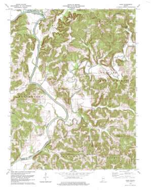
Rusk Topo Map Indiana
To zoom in, hover over the map of Rusk
USGS Topo Quad 38086e7 - 1:24,000 scale
| Topo Map Name: | Rusk |
| USGS Topo Quad ID: | 38086e7 |
| Print Size: | ca. 21 1/4" wide x 27" high |
| Southeast Coordinates: | 38.5° N latitude / 86.75° W longitude |
| Map Center Coordinates: | 38.5625° N latitude / 86.8125° W longitude |
| U.S. State: | IN |
| Filename: | o38086e7.jpg |
| Download Map JPG Image: | Rusk topo map 1:24,000 scale |
| Map Type: | Topographic |
| Topo Series: | 7.5´ |
| Map Scale: | 1:24,000 |
| Source of Map Images: | United States Geological Survey (USGS) |
| Alternate Map Versions: |
Rusk IN 1956, updated 1958 Download PDF Buy paper map Rusk IN 1978, updated 1979 Download PDF Buy paper map Rusk IN 1993, updated 2000 Download PDF Buy paper map Rusk IN 2010 Download PDF Buy paper map Rusk IN 2013 Download PDF Buy paper map Rusk IN 2016 Download PDF Buy paper map |
| FStopo: | US Forest Service topo Rusk is available: Download FStopo PDF Download FStopo TIF |
1:24,000 Topo Quads surrounding Rusk
> Back to 38086e1 at 1:100,000 scale
> Back to 38086a1 at 1:250,000 scale
> Back to U.S. Topo Maps home
Rusk topo map: Gazetteer
Rusk: Bridges
Brooks Bridge elevation 128m 419′Butler Bridge elevation 135m 442′
Rusk: Falls
Hindostan Falls elevation 128m 419′Rusk: Populated Places
Hindostan Falls elevation 141m 462′Rusk elevation 200m 656′
South Martin elevation 199m 652′
Thales elevation 213m 698′
Windom elevation 144m 472′
Yenne elevation 138m 452′
Rusk: Springs
Qualkenbush Spring elevation 144m 472′Rusk: Streams
Barn Run elevation 145m 475′Blue Creek elevation 133m 436′
Crooked Creek elevation 128m 419′
Elm Creek elevation 134m 439′
Grassy Creek elevation 137m 449′
Haw Creek elevation 131m 429′
Hoffman Run elevation 130m 426′
Jackman Branch elevation 128m 419′
Lost River elevation 133m 436′
Miller Fork elevation 181m 593′
Plaster Creek elevation 128m 419′
Poplar Creek elevation 131m 429′
Simmons Creek elevation 129m 423′
Virginia Rill elevation 137m 449′
Willow Creek elevation 132m 433′
Wolfe Creek elevation 131m 429′
Rusk: Summits
Goss Hill elevation 223m 731′Schoolhouse Hill elevation 213m 698′
Rusk: Valleys
Coal Hollow elevation 154m 505′Coon Hollow elevation 140m 459′
Harner Hollow elevation 136m 446′
Qualkenbush Hollow elevation 137m 449′
Rusk digital topo map on disk
Buy this Rusk topo map showing relief, roads, GPS coordinates and other geographical features, as a high-resolution digital map file on DVD:


