Florence Topo Map Colorado
To zoom in, hover over the map of Florence
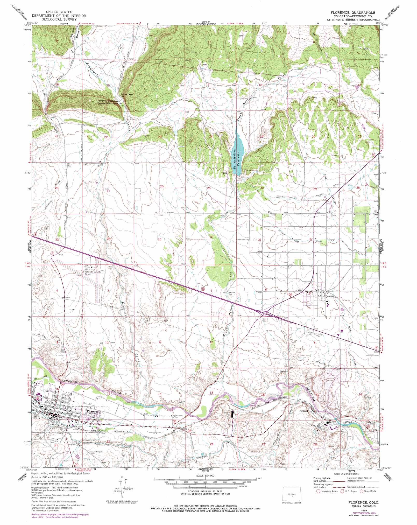
USGS Topo Quad 38105d1 - 1:24,000 scale
| Topo Map Name: | Florence |
| USGS Topo Quad ID: | 38105d1 |
| Print Size: | ca. 21 1/4" wide x 27" high |
| Southeast Coordinates: | 38.375° N latitude / 105° W longitude |
| Map Center Coordinates: | 38.4375° N latitude / 105.0625° W longitude |
| U.S. State: | CO |
| Filename: | o38105d1.jpg |
| Download Map JPG Image: | Florence topo map 1:24,000 scale |
| Map Type: | Topographic |
| Topo Series: | 7.5´ |
| Map Scale: | 1:24,000 |
| Source of Map Images: | United States Geological Survey (USGS) |
| Alternate Map Versions: |
Florence CO 1959, updated 1961 Download PDF Buy paper map Florence CO 1959, updated 1961 Download PDF Buy paper map Florence CO 1959, updated 1963 Download PDF Buy paper map Florence CO 1959, updated 1963 Download PDF Buy paper map Florence CO 1959, updated 1978 Download PDF Buy paper map Florence CO 2010 Download PDF Buy paper map Florence CO 2013 Download PDF Buy paper map Florence CO 2016 Download PDF Buy paper map |
1:24,000 Topo Quads surrounding Florence
High Park |
Cripple Creek South |
Big Bull Mountain |
Mount Big Chief |
Cheyenne Mountain |
Rice Mountain |
Cooper Mountain |
Phantom Canyon |
Mount Pittsburg |
Timber Mountain |
Royal Gorge |
Canon City |
Florence |
Pierce Gulch |
Stone City |
Curley Peak |
Rockvale |
Florence Se |
Hobson |
Swallows |
Mount Tyndall |
Hardscrabble Mountain |
Wetmore |
Owl Canyon |
Beulah Ne |
> Back to 38105a1 at 1:100,000 scale
> Back to 38104a1 at 1:250,000 scale
> Back to U.S. Topo Maps home
Florence topo map: Gazetteer
Florence: Airports
Braun Airport elevation 1682m 5518′Fremont County Airport elevation 1645m 5396′
Florence: Canals
Beaver Park Ditch elevation 1648m 5406′Brush Hollow Supply Ditch elevation 1684m 5524′
Minnequa Canal elevation 1581m 5187′
Union Ditch elevation 1581m 5187′
Florence: Dams
Brush Hollow Dam elevation 1671m 5482′Portland Dam elevation 1582m 5190′
Florence: Mines
Portland Limestone Quarry elevation 1545m 5068′Florence: Populated Places
Florence elevation 1579m 5180′Penrose elevation 1626m 5334′
Portland elevation 1537m 5042′
Florence: Reservoirs
Brush Hollow Reservoir elevation 1671m 5482′Portland Reservoir elevation 1582m 5190′
Florence: Streams
Bear Creek elevation 1531m 5022′Brush Hollow Creek elevation 1548m 5078′
Coal Creek elevation 1567m 5141′
Cocklebur Creek elevation 1552m 5091′
Eightmile Creek elevation 1555m 5101′
Hardscrabble Creek elevation 1538m 5045′
Oak Creek elevation 1567m 5141′
Sixmile Creek elevation 1573m 5160′
Florence: Valleys
Box Canyon elevation 1731m 5679′Phantom Canyon elevation 1758m 5767′
Florence digital topo map on disk
Buy this Florence topo map showing relief, roads, GPS coordinates and other geographical features, as a high-resolution digital map file on DVD: