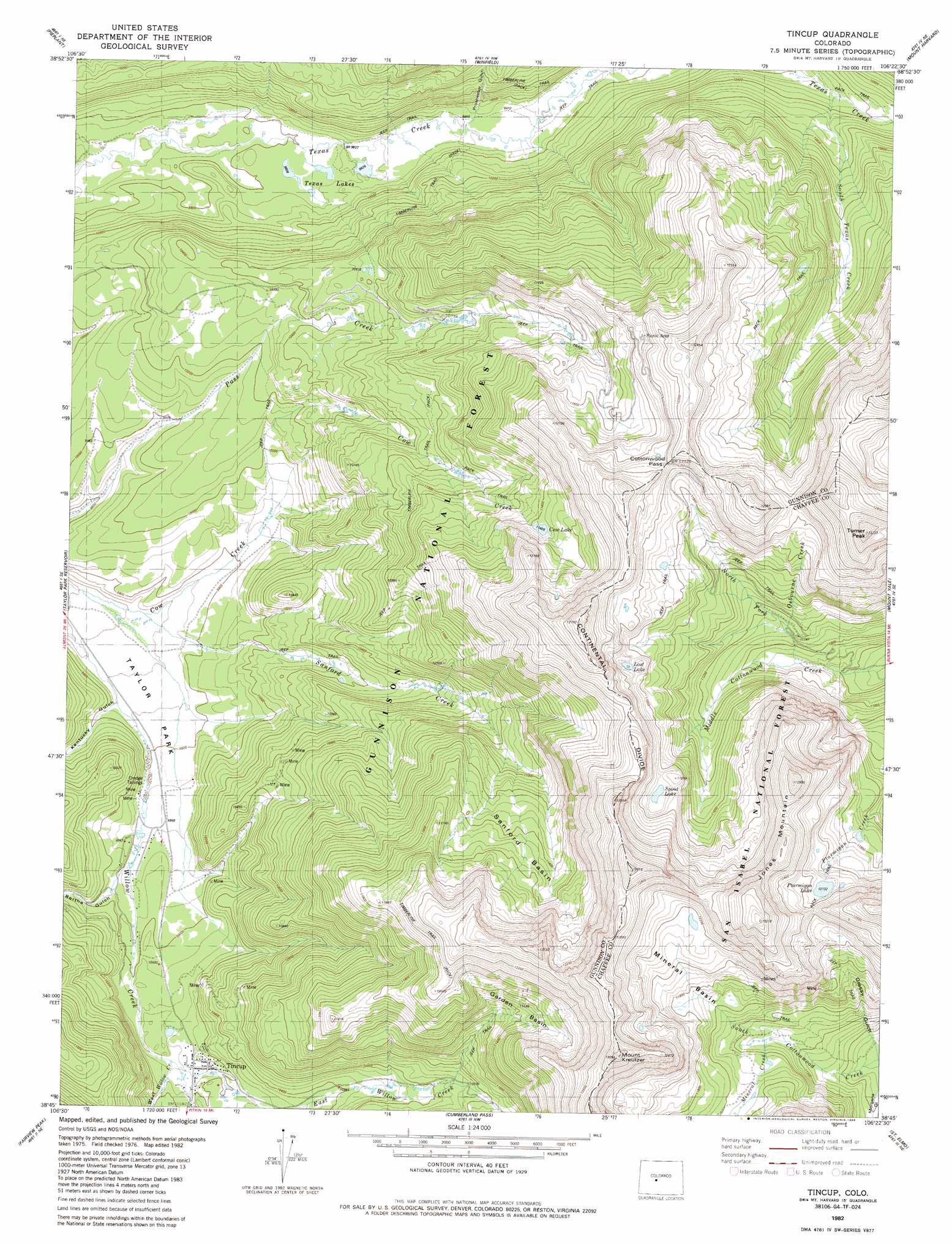
Tincup Topo Map Colorado
To zoom in, hover over the map of Tincup
USGS Topo Quad 38106g4 - 1:24,000 scale
| Topo Map Name: | Tincup |
| USGS Topo Quad ID: | 38106g4 |
| Print Size: | ca. 21 1/4" wide x 27" high |
| Southeast Coordinates: | 38.75° N latitude / 106.375° W longitude |
| Map Center Coordinates: | 38.8125° N latitude / 106.4375° W longitude |
| U.S. State: | CO |
| Filename: | o38106g4.jpg |
| Download Map JPG Image: | Tincup topo map 1:24,000 scale |
| Map Type: | Topographic |
| Topo Series: | 7.5´ |
| Map Scale: | 1:24,000 |
| Source of Map Images: | United States Geological Survey (USGS) |
| Alternate Map Versions: |
Tincup CO 1982, updated 1983 Download PDF Buy paper map Tincup CO 1982, updated 1986 Download PDF Buy paper map Tincup CO 1994, updated 2001 Download PDF Buy paper map Tincup CO 2011 Download PDF Buy paper map Tincup CO 2013 Download PDF Buy paper map Tincup CO 2016 Download PDF Buy paper map |
| FStopo: | US Forest Service topo Tincup is available: Download FStopo PDF Download FStopo TIF |
1:24,000 Topo Quads surrounding Tincup
New York Peak |
Independence Pass |
Mount Elbert |
Granite |
South Peak |
Italian Creek |
Pieplant |
Winfield |
Mount Harvard |
Harvard Lakes |
Matchless Mountain |
Taylor Park Reservoir |
Tincup |
Mount Yale |
Buena Vista West |
Crystal Creek |
Fairview Peak |
Cumberland Pass |
Saint Elmo |
Mount Antero |
Parlin |
Pitkin |
Whitepine |
Garfield |
Maysville |
> Back to 38106e1 at 1:100,000 scale
> Back to 38106a1 at 1:250,000 scale
> Back to U.S. Topo Maps home
Tincup topo map: Gazetteer
Tincup: Basins
Garden Basin elevation 3539m 11610′Mineral Basin elevation 3514m 11528′
Sanford Basin elevation 3378m 11082′
Tincup: Gaps
Cottonwood Pass elevation 3694m 12119′Tincup: Lakes
Cow Lake elevation 3478m 11410′Lost Lake elevation 3630m 11909′
Ptarmigan Lake elevation 3700m 12139′
Spout Lake elevation 3617m 11866′
Texas Lakes elevation 2995m 9826′
Tincup: Mines
Garden Mine elevation 3551m 11650′Iron Ore Lode Mine elevation 3166m 10387′
Tincup: Populated Places
Abbeyville elevation 3027m 9931′Tincup elevation 3096m 10157′
Tincup: Ranges
Sawatch Range elevation 3663m 12017′Tincup: Streams
East Willow Creek elevation 3089m 10134′Middle Willow Creek elevation 3089m 10134′
Mineral Creek elevation 3450m 11318′
North Fork Middle Cottonwood Creek elevation 3349m 10987′
Osbourne Creek elevation 3391m 11125′
Sanford Creek elevation 2943m 9655′
South Texas Creek elevation 3142m 10308′
West Willow Creek elevation 3085m 10121′
Tincup: Summits
Jones Mountain elevation 3994m 13103′Mount Kreutzer elevation 3867m 12687′
Turner Peak elevation 4015m 13172′
Tincup: Valleys
Bertha Gulch elevation 3024m 9921′Grassy Gulch elevation 3309m 10856′
Kentucky Gulch elevation 2968m 9737′
Prospector Gulch elevation 3159m 10364′
Tincup digital topo map on disk
Buy this Tincup topo map showing relief, roads, GPS coordinates and other geographical features, as a high-resolution digital map file on DVD: