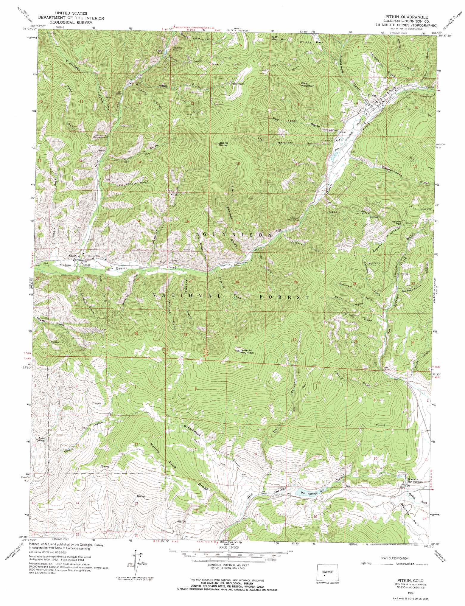
Pitkin Topo Map Colorado
To zoom in, hover over the map of Pitkin
USGS Topo Quad 38106e5 - 1:24,000 scale
| Topo Map Name: | Pitkin |
| USGS Topo Quad ID: | 38106e5 |
| Print Size: | ca. 21 1/4" wide x 27" high |
| Southeast Coordinates: | 38.5° N latitude / 106.5° W longitude |
| Map Center Coordinates: | 38.5625° N latitude / 106.5625° W longitude |
| U.S. State: | CO |
| Filename: | o38106e5.jpg |
| Download Map JPG Image: | Pitkin topo map 1:24,000 scale |
| Map Type: | Topographic |
| Topo Series: | 7.5´ |
| Map Scale: | 1:24,000 |
| Source of Map Images: | United States Geological Survey (USGS) |
| Alternate Map Versions: |
Pitkin CO 1964, updated 1967 Download PDF Buy paper map Pitkin CO 1964, updated 1967 Download PDF Buy paper map Pitkin CO 2001, updated 2004 Download PDF Buy paper map Pitkin CO 2011 Download PDF Buy paper map Pitkin CO 2013 Download PDF Buy paper map Pitkin CO 2016 Download PDF Buy paper map |
| FStopo: | US Forest Service topo Pitkin is available: Download FStopo PDF Download FStopo TIF |
1:24,000 Topo Quads surrounding Pitkin
Cement Mountain |
Matchless Mountain |
Taylor Park Reservoir |
Tincup |
Mount Yale |
Almont |
Crystal Creek |
Fairview Peak |
Cumberland Pass |
Saint Elmo |
Signal Peak |
Parlin |
Pitkin |
Whitepine |
Garfield |
Iris |
Houston Gulch |
Doyleville |
Sargents |
Pahlone Peak |
Sawtooth Mountain |
Razor Creek Dome |
West Baldy |
Sargents Mesa |
Chester |
> Back to 38106e1 at 1:100,000 scale
> Back to 38106a1 at 1:250,000 scale
> Back to U.S. Topo Maps home
Pitkin topo map: Gazetteer
Pitkin: Dams
Hot Springs Creek Dam elevation 2666m 8746′Pitkin: Gaps
Waunita Pass elevation 3129m 10265′Pitkin: Mines
Bazooka Quarry elevation 2849m 9347′Campbird Mine elevation 3122m 10242′
Carter Mine elevation 2819m 9248′
Little Katherine Quarry elevation 2759m 9051′
Lookout Mountain Area Mine elevation 2853m 9360′
Raymond Mine elevation 2875m 9432′
White Spar Number One Mine elevation 3070m 10072′
White Spar Number Two Mine elevation 3070m 10072′
Pitkin: Populated Places
Campbelltown (historical) elevation 3201m 10501′Ohio elevation 2612m 8569′
Pitkin elevation 2809m 9215′
Waunita Hot Springs elevation 2730m 8956′
Pitkin: Reservoirs
Carter Lake elevation 2836m 9304′Hot Springs Reservoir elevation 2678m 8786′
Pitkin: Ridges
Yellow Pine Ridge elevation 3016m 9895′Pitkin: Springs
Line Spring elevation 2669m 8756′Lower Waunita Hot Springs elevation 2713m 8900′
Upper Waunita Hot Springs elevation 2730m 8956′
Pitkin: Streams
Gold Creek elevation 2609m 8559′Spring Creek elevation 2727m 8946′
Pitkin: Summits
Copper Mountain elevation 3188m 10459′Islet Mountain elevation 3349m 10987′
Lookout Mountain elevation 3383m 11099′
Quartz Dome elevation 3444m 11299′
West Mountain elevation 3235m 10613′
Pitkin: Trails
Gunsight Trail elevation 2842m 9324′Pitkin: Valleys
Armstrong Canyon elevation 2801m 9189′Bear Gulch elevation 2730m 8956′
Bluebird Gulch elevation 2610m 8562′
Box Canyon elevation 2652m 8700′
Campbird Gulch elevation 2926m 9599′
Comanche Gulch elevation 2755m 9038′
Dutch Flats Gulch elevation 2866m 9402′
Dutch Gulch elevation 2708m 8884′
Farlee Gulch elevation 2920m 9580′
Fish Hatchery Gulch elevation 2798m 9179′
Freeman Gulch elevation 2979m 9773′
Greathouse Gulch elevation 2646m 8681′
Gurley Gulch elevation 2800m 9186′
Illinois Gulch elevation 2611m 8566′
Independence Gulch elevation 2936m 9632′
Jones Gulch elevation 2805m 9202′
Kimmel Gulch elevation 2830m 9284′
Last Chance Gulch elevation 2690m 8825′
Limekiln Gulch elevation 2829m 9281′
Lincoln Gulch elevation 2803m 9196′
Little Percent Gulch elevation 2717m 8914′
Long Bridge Gulch elevation 2692m 8832′
Lorrain Gulch elevation 2818m 9245′
McIntyre Gulch elevation 2641m 8664′
McIntyre Gulch elevation 2660m 8727′
Mingo Gulch elevation 2914m 9560′
Pole Gulch elevation 2664m 8740′
Powderhouse Gulch elevation 2777m 9110′
Red Jacket Gulch elevation 2793m 9163′
Revenue Gulch elevation 2670m 8759′
Roosevelt Gulch elevation 2739m 8986′
Rosebud Gulch elevation 3039m 9970′
Schoolhouse Gulch elevation 2825m 9268′
Spring Gulch elevation 2863m 9393′
Sullivan Gulch elevation 2914m 9560′
Tie Gulch elevation 2713m 8900′
Wade Gulch elevation 2743m 8999′
Whiskey Gulch elevation 3188m 10459′
Wiley Gulch elevation 2816m 9238′
Pitkin digital topo map on disk
Buy this Pitkin topo map showing relief, roads, GPS coordinates and other geographical features, as a high-resolution digital map file on DVD: