Mcintosh Mountain Topo Map Colorado
To zoom in, hover over the map of Mcintosh Mountain
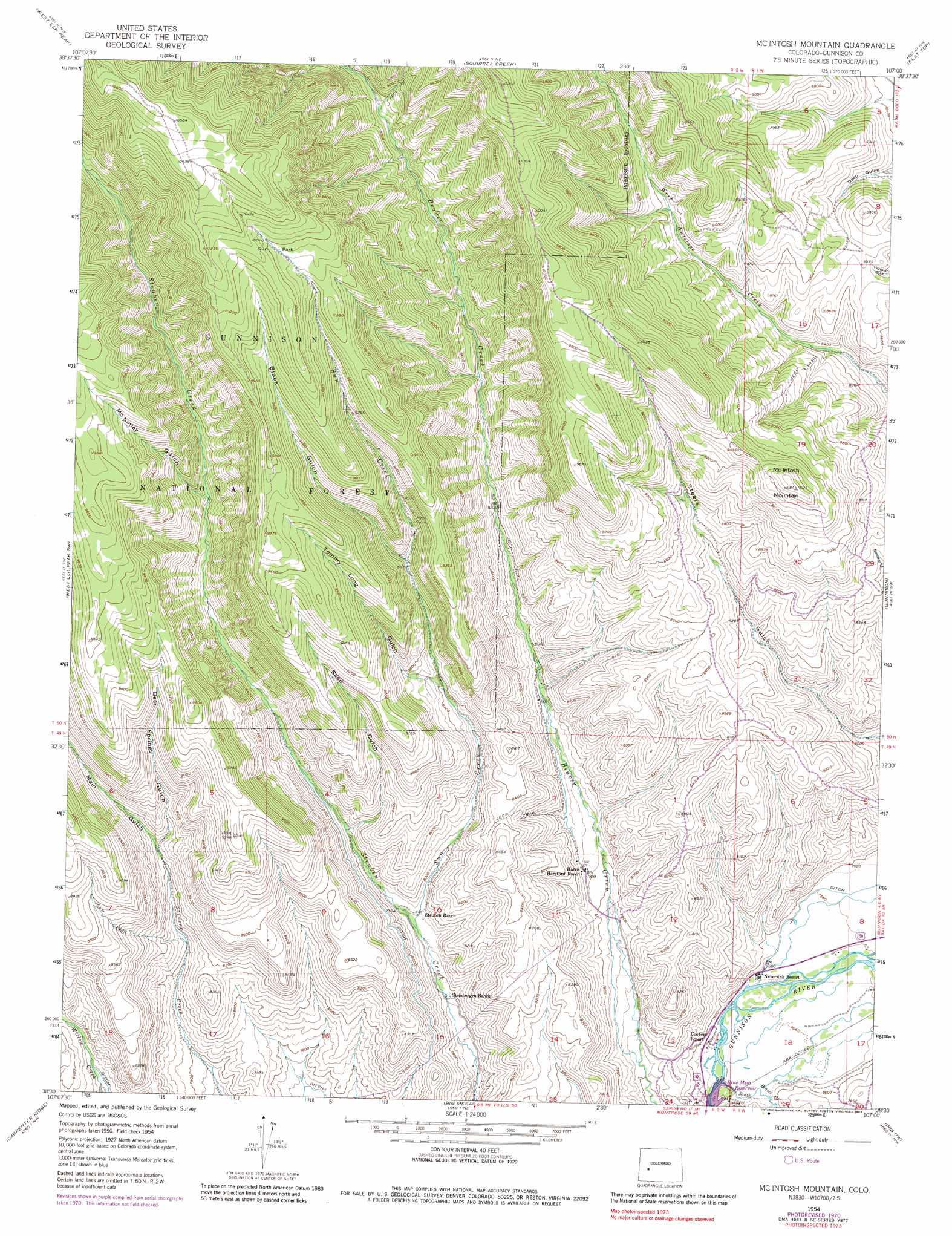
USGS Topo Quad 38107e1 - 1:24,000 scale
| Topo Map Name: | Mcintosh Mountain |
| USGS Topo Quad ID: | 38107e1 |
| Print Size: | ca. 21 1/4" wide x 27" high |
| Southeast Coordinates: | 38.5° N latitude / 107° W longitude |
| Map Center Coordinates: | 38.5625° N latitude / 107.0625° W longitude |
| U.S. State: | CO |
| Filename: | o38107e1.jpg |
| Download Map JPG Image: | Mcintosh Mountain topo map 1:24,000 scale |
| Map Type: | Topographic |
| Topo Series: | 7.5´ |
| Map Scale: | 1:24,000 |
| Source of Map Images: | United States Geological Survey (USGS) |
| Alternate Map Versions: |
Mc Intosh Mountain CO 1954, updated 1955 Download PDF Buy paper map Mc Intosh Mountain CO 1954, updated 1955 Download PDF Buy paper map Mc Intosh Mountain CO 1954, updated 1963 Download PDF Buy paper map Mc Intosh Mountain CO 1954, updated 1963 Download PDF Buy paper map Mc Intosh Mountain CO 1954, updated 1972 Download PDF Buy paper map Mc Intosh Mountain CO 1954, updated 1973 Download PDF Buy paper map Mc Intosh Mountain CO 1954, updated 1973 Download PDF Buy paper map Mc Intosh Mountain CO 1954, updated 1983 Download PDF Buy paper map Mc Intosh Mountain CO 2001, updated 2004 Download PDF Buy paper map McIntosh Mountain CO 2011 Download PDF Buy paper map McIntosh Mountain CO 2013 Download PDF Buy paper map McIntosh Mountain CO 2016 Download PDF Buy paper map |
| FStopo: | US Forest Service topo McIntosh Mountain is available: Download FStopo PDF Download FStopo TIF |
1:24,000 Topo Quads surrounding Mcintosh Mountain
West Beckwith Mountain |
Anthracite Range |
Mount Axtell |
Crested Butte |
Cement Mountain |
Big Soap Park |
West Elk Peak |
Squirrel Creek |
Flat Top |
Almont |
Little Soap Park |
West Elk Peak Sw |
Mcintosh Mountain |
Gunnison |
Signal Peak |
Sapinero |
Carpenter Ridge |
Big Mesa |
Iris Nw |
Iris |
Poison Draw |
Gateview |
Powderhorn |
Spring Hill Creek |
Sawtooth Mountain |
> Back to 38107e1 at 1:100,000 scale
> Back to 38106a1 at 1:250,000 scale
> Back to U.S. Topo Maps home
Mcintosh Mountain topo map: Gazetteer
Mcintosh Mountain: Canals
Cunningham Ditch elevation 2379m 7805′Mcintosh Mountain: Flats
Sun Park elevation 3036m 9960′Mcintosh Mountain: Mines
Steuben Creek Mine elevation 2741m 8992′Steuben Creek Mine elevation 2741m 8992′
Mcintosh Mountain: Reservoirs
The Wayne N Aspinall Unit elevation 2294m 7526′Mcintosh Mountain: Streams
South Beaver Creek elevation 2293m 7522′Sun Creek elevation 2398m 7867′
West Beaver Creek elevation 2676m 8779′
Mcintosh Mountain: Summits
McIntosh Mountain elevation 2905m 9530′Mcintosh Mountain: Valleys
April Gulch elevation 2673m 8769′Bear Springs Gulch elevation 2521m 8270′
Black Gulch elevation 2662m 8733′
Main Gulch elevation 2509m 8231′
McKinley Gulch elevation 2636m 8648′
Reed Gulch elevation 2448m 8031′
Tommy Long Gulch elevation 2557m 8389′
Mcintosh Mountain digital topo map on disk
Buy this Mcintosh Mountain topo map showing relief, roads, GPS coordinates and other geographical features, as a high-resolution digital map file on DVD: