Mount Axtell Topo Map Colorado
To zoom in, hover over the map of Mount Axtell
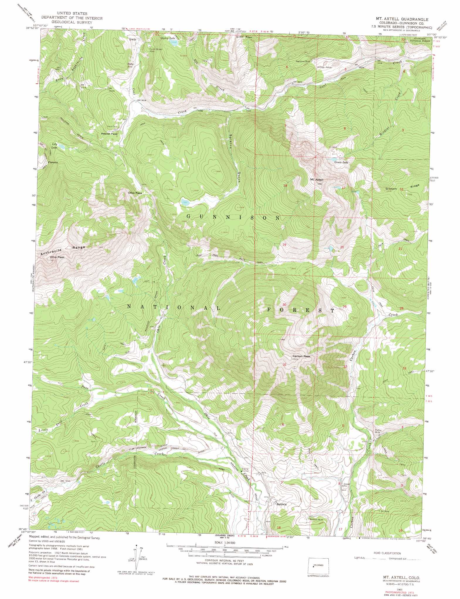
USGS Topo Quad 38107g1 - 1:24,000 scale
| Topo Map Name: | Mount Axtell |
| USGS Topo Quad ID: | 38107g1 |
| Print Size: | ca. 21 1/4" wide x 27" high |
| Southeast Coordinates: | 38.75° N latitude / 107° W longitude |
| Map Center Coordinates: | 38.8125° N latitude / 107.0625° W longitude |
| U.S. State: | CO |
| Filename: | o38107g1.jpg |
| Download Map JPG Image: | Mount Axtell topo map 1:24,000 scale |
| Map Type: | Topographic |
| Topo Series: | 7.5´ |
| Map Scale: | 1:24,000 |
| Source of Map Images: | United States Geological Survey (USGS) |
| Alternate Map Versions: |
Mount Axtell CO 1961, updated 1964 Download PDF Buy paper map Mount Axtell CO 1961, updated 1969 Download PDF Buy paper map Mount Axtell CO 1961, updated 1969 Download PDF Buy paper map Mount Axtell CO 1961, updated 1979 Download PDF Buy paper map Mount Axtell CO 2001, updated 2004 Download PDF Buy paper map Mount Axtell CO 2011 Download PDF Buy paper map Mount Axtell CO 2013 Download PDF Buy paper map Mount Axtell CO 2016 Download PDF Buy paper map |
| FStopo: | US Forest Service topo Mount Axtell is available: Download FStopo PDF Download FStopo TIF |
1:24,000 Topo Quads surrounding Mount Axtell
Chair Mountain |
Marble |
Snowmass Mountain |
Maroon Bells |
Hayden Peak |
Paonia Reservoir |
Marcellina Mountain |
Oh-Be-Joyful |
Gothic |
Pearl Pass |
West Beckwith Mountain |
Anthracite Range |
Mount Axtell |
Crested Butte |
Cement Mountain |
Big Soap Park |
West Elk Peak |
Squirrel Creek |
Flat Top |
Almont |
Little Soap Park |
West Elk Peak Sw |
Mcintosh Mountain |
Gunnison |
Signal Peak |
> Back to 38107e1 at 1:100,000 scale
> Back to 38106a1 at 1:250,000 scale
> Back to U.S. Topo Maps home
Mount Axtell topo map: Gazetteer
Mount Axtell: Canals
Castle Creek Number 1 Ditch elevation 2680m 8792′Elze Webber Ditch elevation 2724m 8937′
Mount Axtell: Gaps
Kebler Pass elevation 3049m 10003′Ohio Pass elevation 3068m 10065′
Mount Axtell: Lakes
Copley Lake elevation 3251m 10666′Green Lake elevation 3242m 10636′
Lily Lake elevation 3107m 10193′
Mount Axtell: Mines
Alpine Mine elevation 2612m 8569′Baldwin Mine elevation 2662m 8733′
Black Diamond Mine elevation 2658m 8720′
Carbon Creek Mine elevation 2737m 8979′
Emmon Mountain Mining and Milling Mine elevation 2780m 9120′
Fan Mine elevation 2666m 8746′
Forest Queen Mine elevation 3152m 10341′
Holly Mine elevation 2754m 9035′
Iron Swamp Mine elevation 3148m 10328′
Keystone Mine elevation 2976m 9763′
Kubler Mine elevation 2709m 8887′
La Plant Mine elevation 2610m 8562′
Mount Emmons Mine elevation 2993m 9819′
New Baldwin Mine elevation 2689m 8822′
Nu Mine elevation 2748m 9015′
Richardson Mine elevation 2783m 9130′
Ruby Mine elevation 3152m 10341′
Spencer Mine elevation 2729m 8953′
Superior Mine elevation 2740m 8989′
Mount Axtell: Populated Places
Baldwin elevation 2672m 8766′Floresta elevation 3011m 9878′
Irwin elevation 3108m 10196′
Ruby elevation 3057m 10029′
Mount Axtell: Post Offices
Floresta Post Office (historical) elevation 3011m 9878′Mount Axtell: Ridges
Gibson Ridge elevation 3368m 11049′Mount Axtell: Streams
Castle Creek elevation 2631m 8631′Elk Creek elevation 2915m 9563′
Little Pass Creek elevation 2742m 8996′
Pass Creek elevation 2645m 8677′
South Castle Creek elevation 2874m 9429′
Wildcat Creek elevation 2768m 9081′
Mount Axtell: Summits
Carbon Peak elevation 3680m 12073′Mount Axtell elevation 3675m 12057′
Ohio Peak elevation 3730m 12237′
Mount Axtell: Valleys
Splains Gulch elevation 2923m 9589′Mount Axtell digital topo map on disk
Buy this Mount Axtell topo map showing relief, roads, GPS coordinates and other geographical features, as a high-resolution digital map file on DVD: