Escalante Forks Topo Map Colorado
To zoom in, hover over the map of Escalante Forks
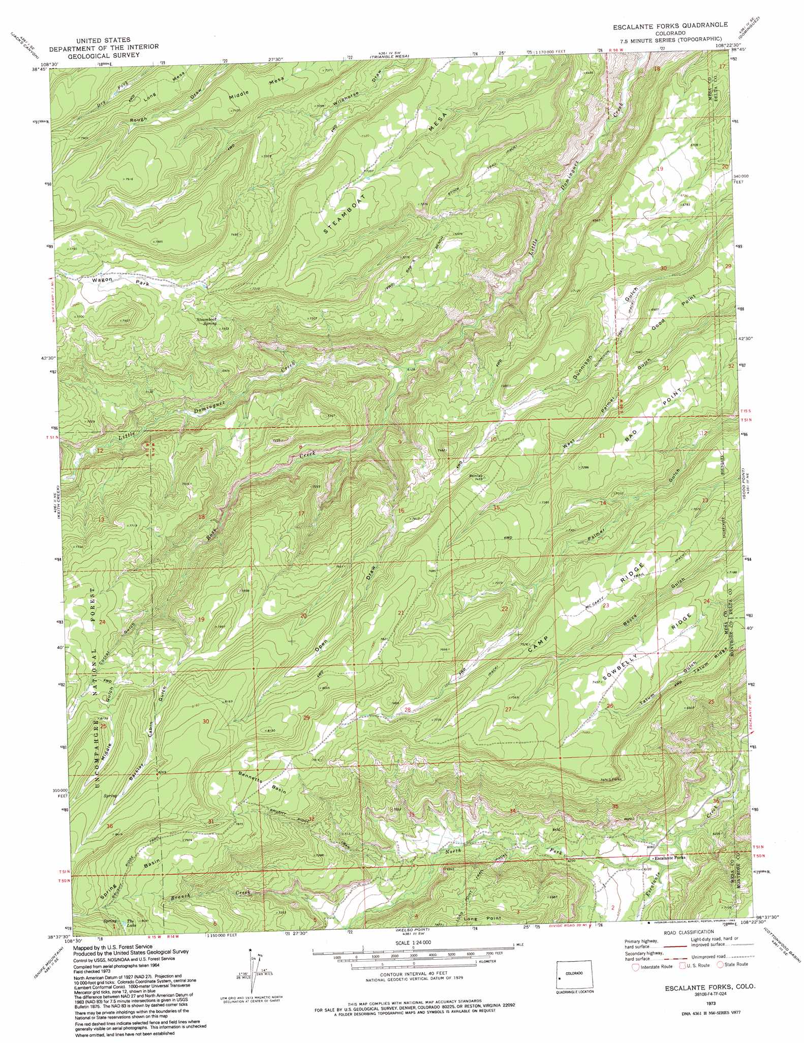
USGS Topo Quad 38108f4 - 1:24,000 scale
| Topo Map Name: | Escalante Forks |
| USGS Topo Quad ID: | 38108f4 |
| Print Size: | ca. 21 1/4" wide x 27" high |
| Southeast Coordinates: | 38.625° N latitude / 108.375° W longitude |
| Map Center Coordinates: | 38.6875° N latitude / 108.4375° W longitude |
| U.S. State: | CO |
| Filename: | o38108f4.jpg |
| Download Map JPG Image: | Escalante Forks topo map 1:24,000 scale |
| Map Type: | Topographic |
| Topo Series: | 7.5´ |
| Map Scale: | 1:24,000 |
| Source of Map Images: | United States Geological Survey (USGS) |
| Alternate Map Versions: |
Escalante Forks CO 1973, updated 1977 Download PDF Buy paper map Escalante Forks CO 1973, updated 1977 Download PDF Buy paper map Escalante Forks CO 1973, updated 1992 Download PDF Buy paper map Escalante Forks CO 2011 Download PDF Buy paper map Escalante Forks CO 2013 Download PDF Buy paper map Escalante Forks CO 2016 Download PDF Buy paper map |
| FStopo: | US Forest Service topo Escalante Forks is available: Download FStopo PDF Download FStopo TIF |
1:24,000 Topo Quads surrounding Escalante Forks
Glade Park |
Island Mesa |
Whitewater |
Juniata Reservoir |
Indian Point |
Snyder Flats |
Jacks Canyon |
Triangle Mesa |
Dominguez |
Point Creek |
Casto Reservoir |
Keith Creek |
Escalante Forks |
Good Point |
Roubideau |
Uncompahgre Butte |
Snipe Mountain |
Kelso Point |
Cottonwood Basin |
Camel Back |
Atkinson Creek |
Windy Point |
Starvation Point |
Moore Mesa |
Davis Point |
> Back to 38108e1 at 1:100,000 scale
> Back to 38108a1 at 1:250,000 scale
> Back to U.S. Topo Maps home
Escalante Forks topo map: Gazetteer
Escalante Forks: Basins
Bennetts Basin elevation 2377m 7798′Spring Basin elevation 2430m 7972′
Escalante Forks: Lakes
The Lake elevation 2486m 8156′Escalante Forks: Ridges
Bad Point elevation 2220m 7283′Escalante Forks: Springs
Steamboat Spring elevation 2222m 7290′Escalante Forks: Streams
Branch Creek elevation 2030m 6660′North Fork Escalante Creek elevation 1851m 6072′
Rose Creek elevation 1871m 6138′
Escalante Forks: Summits
Good Point elevation 2149m 7050′Long Mesa elevation 2408m 7900′
Steamboat Mesa elevation 2331m 7647′
Escalante Forks: Trails
Bar X Bench Stock Trail elevation 2060m 6758′Bax X Bench Stock Trail elevation 2066m 6778′
Escalante Forks: Valleys
Barkely Cabin Gulch elevation 2217m 7273′Barklay Cabin Gulch elevation 2267m 7437′
Corral Gulch elevation 2216m 7270′
Middle Gulch elevation 2274m 7460′
Open Draw elevation 1913m 6276′
Escalante Forks digital topo map on disk
Buy this Escalante Forks topo map showing relief, roads, GPS coordinates and other geographical features, as a high-resolution digital map file on DVD: