Steves Mountain Topo Map Utah
To zoom in, hover over the map of Steves Mountain
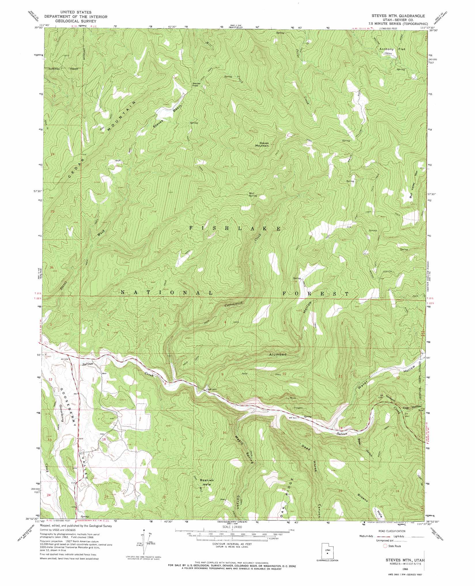
USGS Topo Quad 38111h6 - 1:24,000 scale
| Topo Map Name: | Steves Mountain |
| USGS Topo Quad ID: | 38111h6 |
| Print Size: | ca. 21 1/4" wide x 27" high |
| Southeast Coordinates: | 38.875° N latitude / 111.625° W longitude |
| Map Center Coordinates: | 38.9375° N latitude / 111.6875° W longitude |
| U.S. State: | UT |
| Filename: | o38111h6.jpg |
| Download Map JPG Image: | Steves Mountain topo map 1:24,000 scale |
| Map Type: | Topographic |
| Topo Series: | 7.5´ |
| Map Scale: | 1:24,000 |
| Source of Map Images: | United States Geological Survey (USGS) |
| Alternate Map Versions: |
Steves Mtn UT 1966, updated 1968 Download PDF Buy paper map Steves Mountain UT 2001, updated 2003 Download PDF Buy paper map Steves Mountain UT 2011 Download PDF Buy paper map Steves Mountain UT 2014 Download PDF Buy paper map |
| FStopo: | US Forest Service topo Steves Mountain is available: Download FStopo PDF Download FStopo TIF |
1:24,000 Topo Quads surrounding Steves Mountain
Hayes Canyon |
Gunnison |
Sterling |
Black Mountain |
Ferron Reservoir |
Redmond Canyon |
Redmond |
Mayfield |
Woods Lake |
Heliotrope Mountain |
Aurora |
Salina |
Steves Mountain |
Water Hollow Ridge |
Acord Lakes |
Sigurd |
Rex Reservoir |
Gooseberry Creek |
Yogo Creek |
Old Woman Plateau |
Water Creek Canyon |
Boobe Hole Reservoir |
Mount Terrill |
Hilgard Mountain |
Johns Peak |
> Back to 38111e1 at 1:100,000 scale
> Back to 38110a1 at 1:250,000 scale
> Back to U.S. Topo Maps home
Steves Mountain topo map: Gazetteer
Steves Mountain: Basins
Beanies Hole elevation 2069m 6788′Steves Basin elevation 2163m 7096′
Steves Mountain: Flats
Anthony Flat elevation 2353m 7719′Steves Mountain: Gaps
Steves Pass elevation 2241m 7352′Steves Mountain: Springs
Mud Spring elevation 2377m 7798′Steves Mountain: Streams
Cottonwood Creek elevation 1775m 5823′Steves Mountain: Summits
Bull Valley Mountain elevation 2829m 9281′Cedar Mountain elevation 2370m 7775′
Sawtooth elevation 1952m 6404′
Steves Mountain elevation 2665m 8743′
Steves Mountain: Trails
Oak Belt Trail elevation 1886m 6187′Steves Mountain: Valleys
Alumbed Hollow elevation 1792m 5879′Bear Gulch elevation 1890m 6200′
Browns Hole elevation 1960m 6430′
Coal Hollow elevation 1925m 6315′
Dead Horse Canyon elevation 1846m 6056′
Maple Spring Canyon elevation 1828m 5997′
Water Hollow elevation 2142m 7027′
Steves Mountain digital topo map on disk
Buy this Steves Mountain topo map showing relief, roads, GPS coordinates and other geographical features, as a high-resolution digital map file on DVD: