Boobe Hole Reservoir Topo Map Utah
To zoom in, hover over the map of Boobe Hole Reservoir
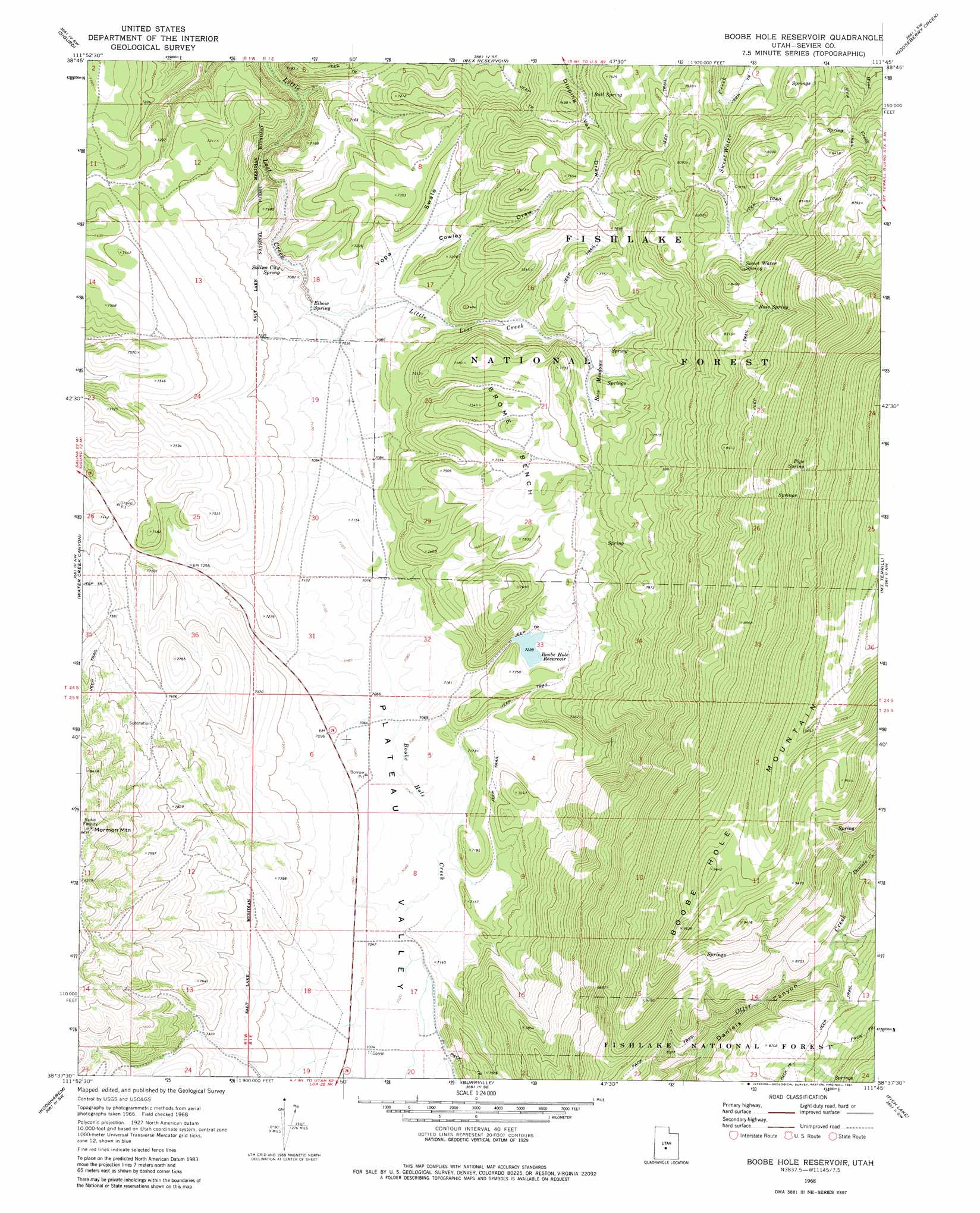
USGS Topo Quad 38111f7 - 1:24,000 scale
| Topo Map Name: | Boobe Hole Reservoir |
| USGS Topo Quad ID: | 38111f7 |
| Print Size: | ca. 21 1/4" wide x 27" high |
| Southeast Coordinates: | 38.625° N latitude / 111.75° W longitude |
| Map Center Coordinates: | 38.6875° N latitude / 111.8125° W longitude |
| U.S. State: | UT |
| Filename: | o38111f7.jpg |
| Download Map JPG Image: | Boobe Hole Reservoir topo map 1:24,000 scale |
| Map Type: | Topographic |
| Topo Series: | 7.5´ |
| Map Scale: | 1:24,000 |
| Source of Map Images: | United States Geological Survey (USGS) |
| Alternate Map Versions: |
Boobe Hole Reservoir UT 1968, updated 1972 Download PDF Buy paper map Boobe Hole Reservoir UT 1968, updated 1981 Download PDF Buy paper map Boobe Hole Reservoir UT 2001, updated 2003 Download PDF Buy paper map Boobe Hole Reservoir UT 2011 Download PDF Buy paper map Boobe Hole Reservoir UT 2014 Download PDF Buy paper map |
| FStopo: | US Forest Service topo Boobe Hole Reservoir is available: Download FStopo PDF Download FStopo TIF |
1:24,000 Topo Quads surrounding Boobe Hole Reservoir
Beehive Peak |
Aurora |
Salina |
Steves Mountain |
Water Hollow Ridge |
Richfield |
Sigurd |
Rex Reservoir |
Gooseberry Creek |
Yogo Creek |
Annabella |
Water Creek Canyon |
Boobe Hole Reservoir |
Mount Terrill |
Hilgard Mountain |
Monroe Peak |
Koosharem |
Burrville |
Fish Lake |
Forsyth Reservoir |
Marysvale Peak |
Greenwich |
Abes Knoll |
Loa |
Lyman |
> Back to 38111e1 at 1:100,000 scale
> Back to 38110a1 at 1:250,000 scale
> Back to U.S. Topo Maps home
Boobe Hole Reservoir topo map: Gazetteer
Boobe Hole Reservoir: Benches
Brome Bench elevation 2266m 7434′Boobe Hole Reservoir: Dams
Boobe Hole Dam elevation 2204m 7230′Boobe Hole Reservoir: Flats
Rose Meadows elevation 2278m 7473′Boobe Hole Reservoir: Reservoirs
Boobe Hole Reservoir elevation 2202m 7224′Boobe Hole Reservoir: Springs
Bull Spring elevation 2250m 7381′Elbow Spring elevation 2142m 7027′
Pipe Spring elevation 2885m 9465′
Rose Spring elevation 2532m 8307′
Salina City Spring elevation 2134m 7001′
Sweet Water Spring elevation 2494m 8182′
Boobe Hole Reservoir: Streams
Daniels Creek elevation 2617m 8585′Boobe Hole Reservoir: Summits
Mormon Mountain elevation 2626m 8615′Boobe Hole Reservoir: Valleys
Lagoon elevation 2159m 7083′Yopa Swale elevation 2147m 7043′
Boobe Hole Reservoir digital topo map on disk
Buy this Boobe Hole Reservoir topo map showing relief, roads, GPS coordinates and other geographical features, as a high-resolution digital map file on DVD: