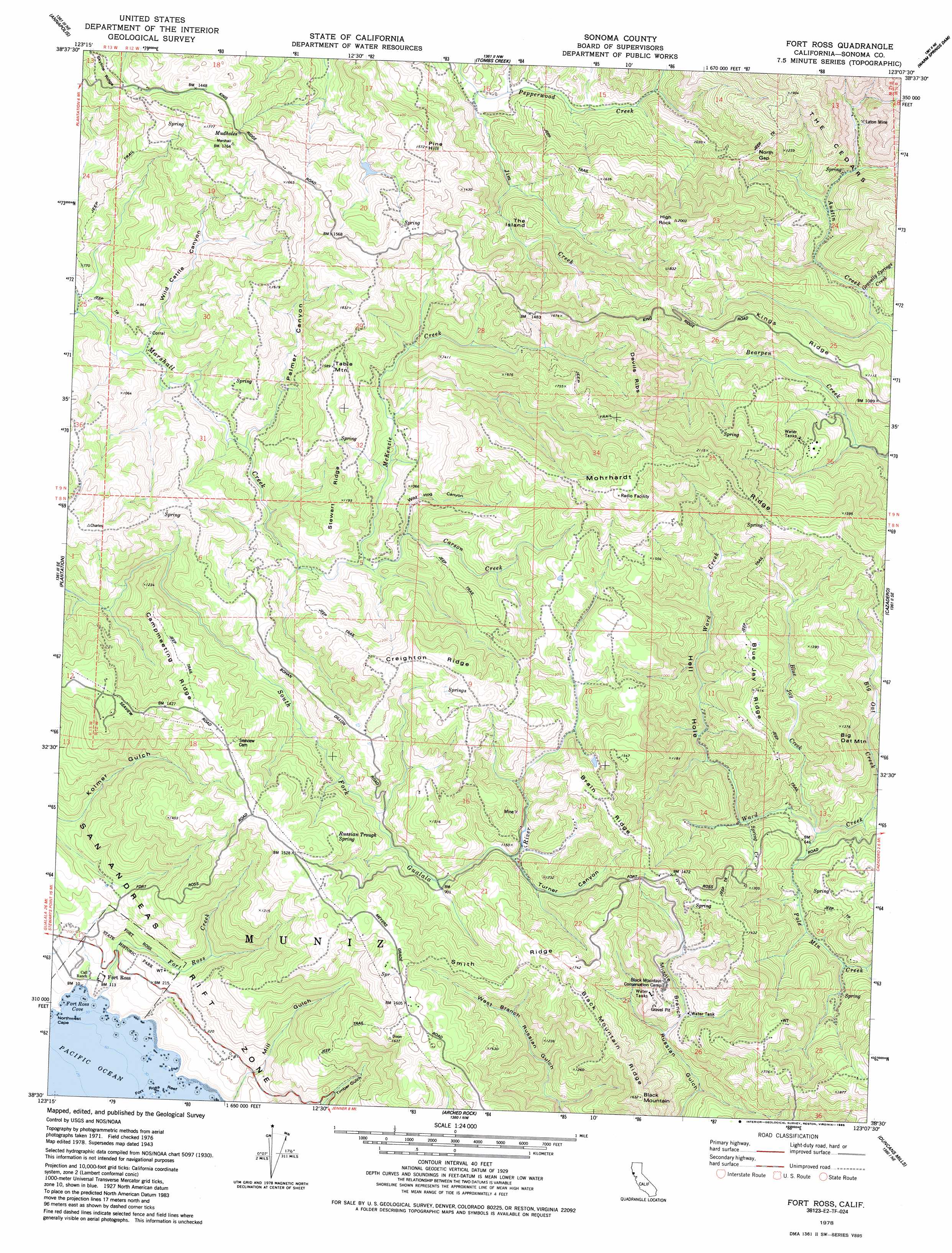
Fort Ross Topo Map California
To zoom in, hover over the map of Fort Ross
USGS Topo Quad 38123e2 - 1:24,000 scale
| Topo Map Name: | Fort Ross |
| USGS Topo Quad ID: | 38123e2 |
| Print Size: | ca. 21 1/4" wide x 27" high |
| Southeast Coordinates: | 38.5° N latitude / 123.125° W longitude |
| Map Center Coordinates: | 38.5625° N latitude / 123.1875° W longitude |
| U.S. State: | CA |
| Filename: | o38123e2.jpg |
| Download Map JPG Image: | Fort Ross topo map 1:24,000 scale |
| Map Type: | Topographic |
| Topo Series: | 7.5´ |
| Map Scale: | 1:24,000 |
| Source of Map Images: | United States Geological Survey (USGS) |
| Alternate Map Versions: |
Fort Ross CA 1943, updated 1958 Download PDF Buy paper map Fort Ross CA 1943, updated 1966 Download PDF Buy paper map Fort Ross CA 1978, updated 1978 Download PDF Buy paper map Fort Ross CA 1978, updated 1985 Download PDF Buy paper map Fort Ross CA 1998, updated 2002 Download PDF Buy paper map Fort Ross CA 2012 Download PDF Buy paper map Fort Ross CA 2015 Download PDF Buy paper map |
1:24,000 Topo Quads surrounding Fort Ross
Mcguire Ridge |
Gube Mountain |
Big Foot Mountain |
Cloverdale |
Asti |
Stewarts Point |
Annapolis |
Tombs Creek |
Warm Springs Dam |
Geyserville |
Plantation |
Fort Ross |
Cazadero |
Guerneville |
|
Arched Rock |
Duncans Mills |
Camp Meeker |
||
Bodega Head |
Valley Ford |
> Back to 38123e1 at 1:100,000 scale
> Back to 38122a1 at 1:250,000 scale
> Back to U.S. Topo Maps home
Fort Ross topo map: Gazetteer
Fort Ross: Areas
Meteni elevation 44m 144′Fort Ross: Bars
Fort Ross Reef elevation 0m 0′Fort Ross: Bays
Fort Ross Cove elevation 0m 0′Fort Ross: Dams
Richardson 1429 Dam elevation 183m 600′Fort Ross: Gaps
North Gap elevation 387m 1269′Fort Ross: Mines
Laton Mine elevation 295m 967′Fort Ross: Parks
Fort Ross (historical) elevation 37m 121′Fort Ross State Historic Park elevation 25m 82′
Fort Ross: Pillars
High Rock elevation 596m 1955′Fort Ross: Populated Places
Seaview elevation 439m 1440′Toners Place elevation 303m 994′
Truth Home elevation 296m 971′
Fort Ross: Ridges
Black Mountain Ridge elevation 466m 1528′Blue Jay Ridge elevation 430m 1410′
Brain Ridge elevation 456m 1496′
Campmeeting Ridge elevation 377m 1236′
Creighton Ridge elevation 527m 1729′
Kings Ridge elevation 357m 1171′
Mohrhardt Ridge elevation 710m 2329′
Smith Ridge elevation 433m 1420′
Stewart Ridge elevation 359m 1177′
Fort Ross: Springs
Gravelly Spring elevation 290m 951′Mudholes elevation 491m 1610′
Russian Trough Spring elevation 430m 1410′
Fort Ross: Streams
Big Oat Creek elevation 131m 429′Blue Jay Creek elevation 154m 505′
Carson Creek elevation 195m 639′
Fort Ross Creek elevation 0m 0′
Grasshopper Creek elevation 202m 662′
Gravelly Springs Creek elevation 154m 505′
Jim Creek elevation 171m 561′
McKenzie Creek elevation 195m 639′
Pole Mountain Creek elevation 160m 524′
Spring Creek elevation 170m 557′
Fort Ross: Summits
Big Oat Mountain elevation 416m 1364′Black Mountain elevation 493m 1617′
Devils Ribs elevation 578m 1896′
Pine Hill elevation 467m 1532′
Table Mountain elevation 482m 1581′
The Island elevation 367m 1204′
Fort Ross: Valleys
Hell Hole elevation 171m 561′Palmer Canyon elevation 171m 561′
Turner Canyon elevation 287m 941′
Wild Cattle Canyon elevation 155m 508′
Wild Hog Canyon elevation 215m 705′
Fort Ross: Woods
Russian Orchard elevation 103m 337′Stanley S Spyra Memorial Grove elevation 101m 331′
Fort Ross digital topo map on disk
Buy this Fort Ross topo map showing relief, roads, GPS coordinates and other geographical features, as a high-resolution digital map file on DVD: