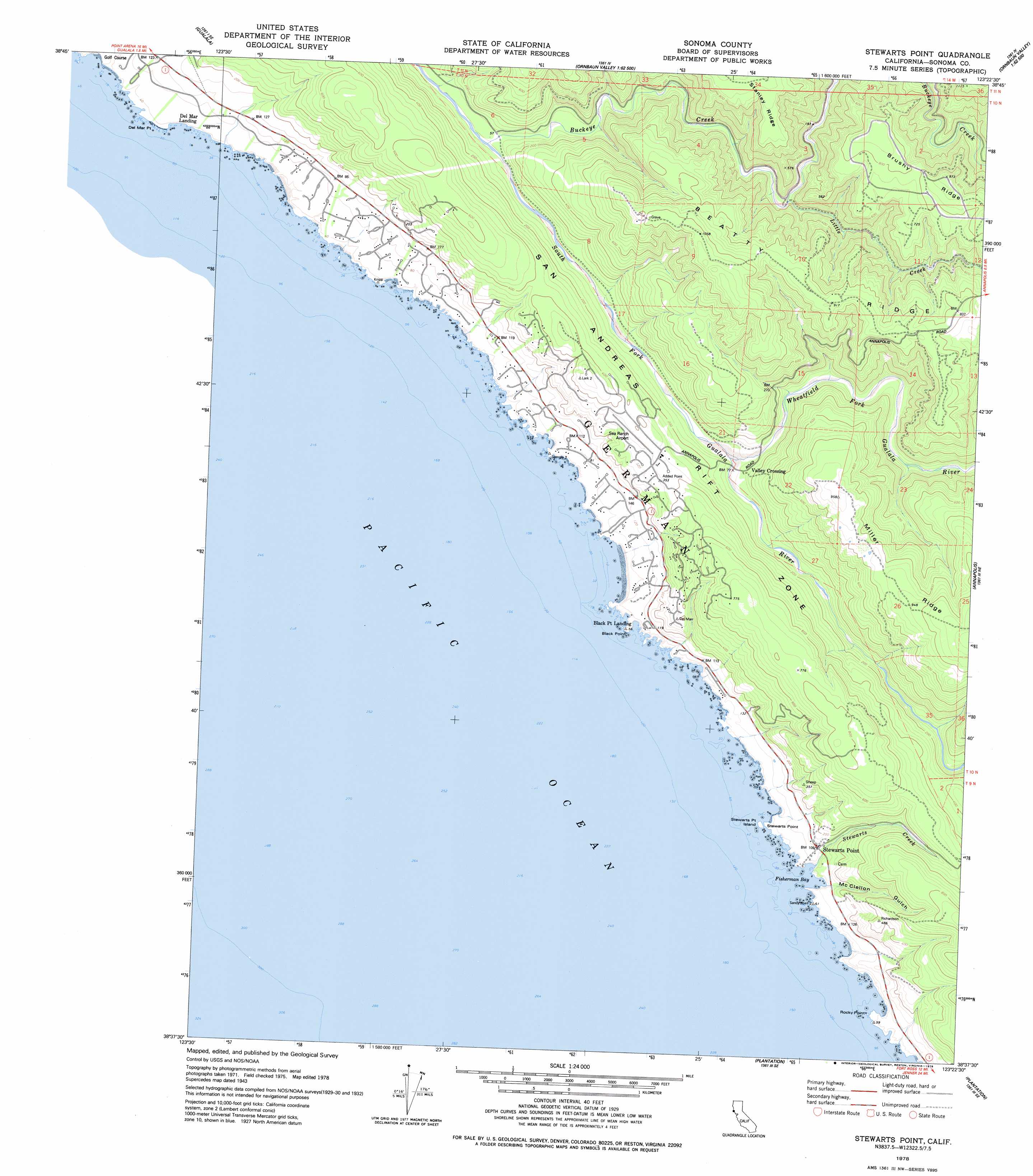
Stewarts Point Topo Map California
To zoom in, hover over the map of Stewarts Point
USGS Topo Quad 38123f4 - 1:24,000 scale
| Topo Map Name: | Stewarts Point |
| USGS Topo Quad ID: | 38123f4 |
| Print Size: | ca. 21 1/4" wide x 27" high |
| Southeast Coordinates: | 38.625° N latitude / 123.375° W longitude |
| Map Center Coordinates: | 38.6875° N latitude / 123.4375° W longitude |
| U.S. State: | CA |
| Filename: | o38123f4.jpg |
| Download Map JPG Image: | Stewarts Point topo map 1:24,000 scale |
| Map Type: | Topographic |
| Topo Series: | 7.5´ |
| Map Scale: | 1:24,000 |
| Source of Map Images: | United States Geological Survey (USGS) |
| Alternate Map Versions: |
Stewarts Point CA 1943, updated 1956 Download PDF Buy paper map Stewarts Point CA 1943, updated 1968 Download PDF Buy paper map Stewarts Point CA 1943, updated 1973 Download PDF Buy paper map Stewarts Point CA 1978, updated 1978 Download PDF Buy paper map Stewarts Point CA 2012 Download PDF Buy paper map Stewarts Point CA 2015 Download PDF Buy paper map |
1:24,000 Topo Quads surrounding Stewarts Point
Point Arena |
Eureka Hill |
Zeni Ridge |
Ornbaun Valley |
Yorkville |
Saunders Reef |
Gualala |
Mcguire Ridge |
Gube Mountain |
Big Foot Mountain |
Stewarts Point |
Annapolis |
Tombs Creek |
||
Plantation |
Fort Ross |
|||
Arched Rock |
> Back to 38123e1 at 1:100,000 scale
> Back to 38122a1 at 1:250,000 scale
> Back to U.S. Topo Maps home
Stewarts Point topo map: Gazetteer
Stewarts Point: Airports
The Sea Ranch Airport elevation 105m 344′Stewarts Point: Bays
Fisherman Bay elevation 0m 0′Stewarts Point: Beaches
Black Point Beach elevation 0m 0′Pebble Beach elevation 6m 19′
Stewarts Point: Capes
Black Point elevation 13m 42′Rocky Point elevation 4m 13′
Stewarts Point elevation 2m 6′
Stewarts Point: Islands
Stewarts Point Island elevation 0m 0′Stewarts Point: Populated Places
Sea Ranch elevation 34m 111′Stewarts Point elevation 33m 108′
Valley Crossing elevation 32m 104′
Stewarts Point: Ridges
Beatty Ridge elevation 275m 902′Brushy Ridge elevation 296m 971′
Stewarts Point: Streams
Buckeye Creek elevation 13m 42′Little Creek elevation 37m 121′
Stewarts Creek elevation 7m 22′
Wheatfield Fork Gualala River elevation 18m 59′
Stewarts Point: Valleys
McClellon Gulch elevation 7m 22′Stewarts Point digital topo map on disk
Buy this Stewarts Point topo map showing relief, roads, GPS coordinates and other geographical features, as a high-resolution digital map file on DVD: