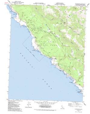
Plantation Topo Map California
To zoom in, hover over the map of Plantation
USGS Topo Quad 38123e3 - 1:24,000 scale
| Topo Map Name: | Plantation |
| USGS Topo Quad ID: | 38123e3 |
| Print Size: | ca. 21 1/4" wide x 27" high |
| Southeast Coordinates: | 38.5° N latitude / 123.25° W longitude |
| Map Center Coordinates: | 38.5625° N latitude / 123.3125° W longitude |
| U.S. State: | CA |
| Filename: | o38123e3.jpg |
| Download Map JPG Image: | Plantation topo map 1:24,000 scale |
| Map Type: | Topographic |
| Topo Series: | 7.5´ |
| Map Scale: | 1:24,000 |
| Source of Map Images: | United States Geological Survey (USGS) |
| Alternate Map Versions: |
Plantation CA 1943, updated 1956 Download PDF Buy paper map Plantation CA 1943, updated 1956 Download PDF Buy paper map Plantation CA 1943, updated 1967 Download PDF Buy paper map Plantation CA 1977, updated 1978 Download PDF Buy paper map Plantation CA 1977, updated 1985 Download PDF Buy paper map Plantation CA 2012 Download PDF Buy paper map Plantation CA 2015 Download PDF Buy paper map |
1:24,000 Topo Quads surrounding Plantation
Gualala |
Mcguire Ridge |
Gube Mountain |
Big Foot Mountain |
Cloverdale |
Stewarts Point |
Annapolis |
Tombs Creek |
Warm Springs Dam |
|
Plantation |
Fort Ross |
Cazadero |
||
Arched Rock |
Duncans Mills |
|||
Bodega Head |
> Back to 38123e1 at 1:100,000 scale
> Back to 38122a1 at 1:250,000 scale
> Back to U.S. Topo Maps home
Plantation topo map: Gazetteer
Plantation: Bays
Fisk Mill Cove elevation 0m 0′Gerstle Cove elevation 0m 0′
Horseshoe Cove elevation 0m 0′
Ocean Cove elevation 0m 0′
Stillwater Cove elevation 0m 0′
Stump Beach Cove elevation 5m 16′
Timber Cove elevation 0m 0′
Plantation: Beaches
Clam Beach elevation 0m 0′Stump Beach elevation 0m 0′
Plantation: Bridges
Hauser Bridge elevation 106m 347′Plantation: Capes
Horseshoe Point elevation 24m 78′Northwest Cape elevation 12m 39′
Salt Point elevation 12m 39′
Windermere Point elevation 22m 72′
Plantation: Lakes
Lake Lower elevation 231m 757′Plantation: Parks
Gerstle Cove Reserve elevation 0m 0′Salt Point State Park elevation 204m 669′
Stillwater Cove Regional Park elevation 17m 55′
Plantation: Pillars
Sentinel Rock elevation 3m 9′Plantation: Populated Places
Walsh Landing elevation 38m 124′Plantation: Reservoirs
Lake Oliver elevation 240m 787′Plantation: Streams
Marshall Creek elevation 110m 360′Miller Creek elevation 3m 9′
Sproule Creek elevation 147m 482′
Stockhoff Creek elevation 2m 6′
Timber Cove Creek elevation 4m 13′
Warren Creek elevation 6m 19′
Wildcat Creek elevation 18m 59′
Plantation: Trails
Plantation Trail elevation 265m 869′Stump Beach Trail elevation 149m 488′
Plantation: Valleys
Cannon Gulch elevation 11m 36′Chinese Gulch elevation 3m 9′
Deadman Gulch elevation 1m 3′
Kolmer Gulch elevation 10m 32′
Phillips Gulch elevation 5m 16′
Plantation: Woods
Pygmy Forest elevation 263m 862′Plantation digital topo map on disk
Buy this Plantation topo map showing relief, roads, GPS coordinates and other geographical features, as a high-resolution digital map file on DVD:


