Hammonton Topo Map New Jersey
To zoom in, hover over the map of Hammonton
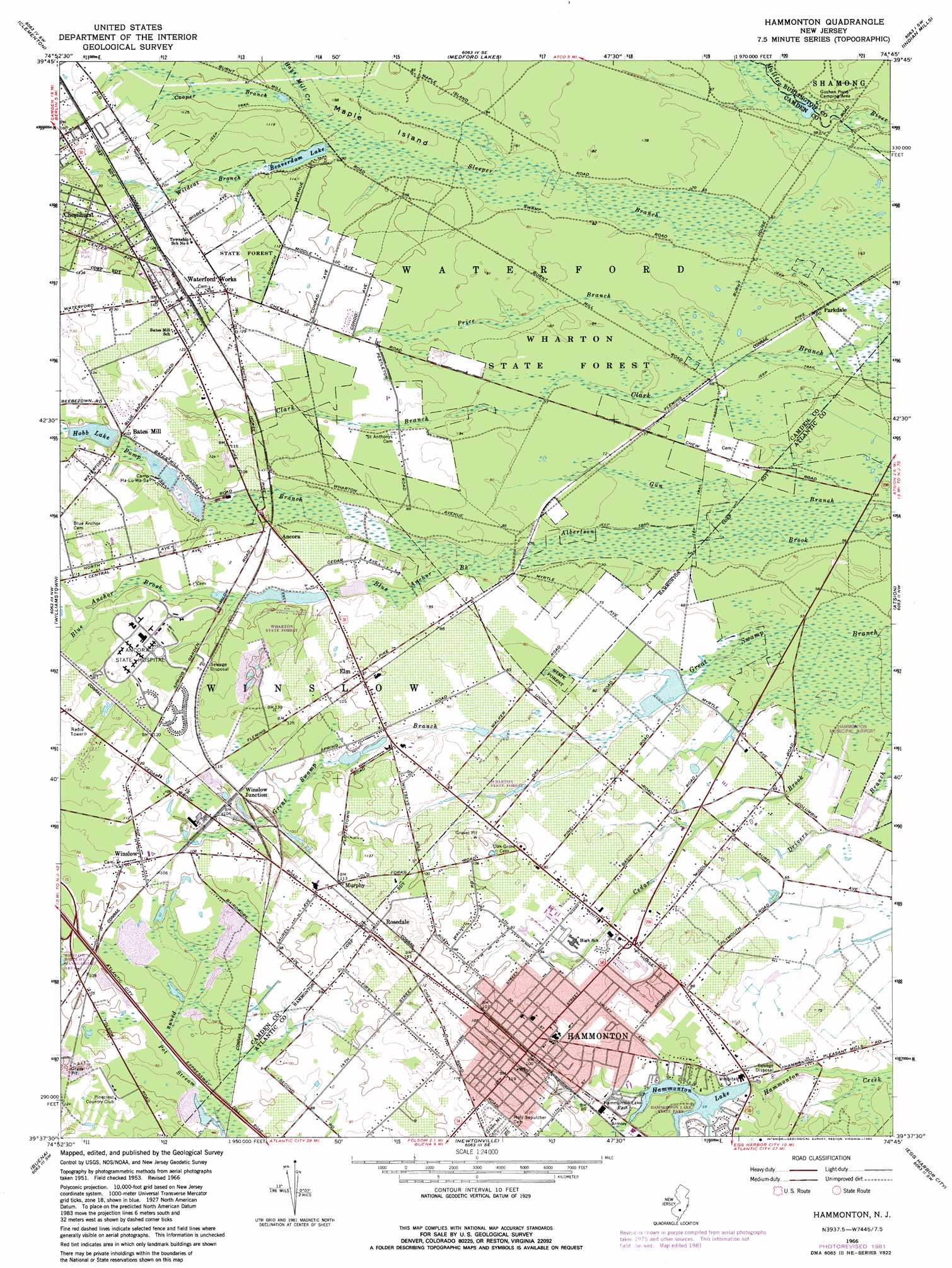
USGS Topo Quad 39074f7 - 1:24,000 scale
| Topo Map Name: | Hammonton |
| USGS Topo Quad ID: | 39074f7 |
| Print Size: | ca. 21 1/4" wide x 27" high |
| Southeast Coordinates: | 39.625° N latitude / 74.75° W longitude |
| Map Center Coordinates: | 39.6875° N latitude / 74.8125° W longitude |
| U.S. State: | NJ |
| Filename: | o39074f7.jpg |
| Download Map JPG Image: | Hammonton topo map 1:24,000 scale |
| Map Type: | Topographic |
| Topo Series: | 7.5´ |
| Map Scale: | 1:24,000 |
| Source of Map Images: | United States Geological Survey (USGS) |
| Alternate Map Versions: |
Hammonton NJ 1953, updated 1954 Download PDF Buy paper map Hammonton NJ 1953, updated 1968 Download PDF Buy paper map Hammonton NJ 1966, updated 1968 Download PDF Buy paper map Hammonton NJ 1966, updated 1974 Download PDF Buy paper map Hammonton NJ 1966, updated 1982 Download PDF Buy paper map Hammonton NJ 1966, updated 1982 Download PDF Buy paper map Hammonton NJ 2011 Download PDF Buy paper map Hammonton NJ 2014 Download PDF Buy paper map Hammonton NJ 2016 Download PDF Buy paper map |
1:24,000 Topo Quads surrounding Hammonton
Camden |
Moorestown |
Mount Holly |
Pemberton |
Browns Mills |
Runnemede |
Clementon |
Medford Lakes |
Indian Mills |
Chatsworth |
Pitman East |
Williamstown |
Hammonton |
Atsion |
Jenkins |
Newfield |
Buena |
Newtonville |
Egg Harbor City |
Green Bank |
Millville |
Five Points |
Dorothy |
Mays Landing |
Pleasantville |
> Back to 39074e1 at 1:100,000 scale
> Back to 39074a1 at 1:250,000 scale
> Back to U.S. Topo Maps home
Hammonton topo map: Gazetteer
Hammonton: Airports
Hammonton Municipal Airport elevation 21m 68′Ideal Manufacturing Corporation Airport elevation 27m 88′
Rusnaks Private Strip elevation 19m 62′
Hammonton: Dams
Beaverdam Lake Dam elevation 27m 88′Hammonton Lake Dam elevation 19m 62′
Hobb Lake Dam elevation 28m 91′
Hammonton: Forests
Wharton State Forest elevation 23m 75′Hammonton: Islands
Maple Island elevation 27m 88′Hammonton: Parks
Goshen Pond Camping Area elevation 15m 49′Hammonton Lake Park elevation 24m 78′
Hammonton: Populated Places
Ancora elevation 30m 98′Bates Mill elevation 32m 104′
Dunbarton elevation 41m 134′
Elm elevation 30m 98′
Hammonton elevation 29m 95′
Murphy elevation 35m 114′
Parkdale elevation 18m 59′
Pestletown elevation 27m 88′
Rosedale elevation 39m 127′
Waterford Works elevation 36m 118′
Winslow elevation 34m 111′
Winslow Junction elevation 33m 108′
Hammonton: Reservoirs
Anchor Lake One elevation 25m 82′Anchor Lake Two elevation 25m 82′
Beaverdam Lake elevation 27m 88′
Hammonton Lake elevation 19m 62′
Hobb Lake elevation 28m 91′
Hammonton: Streams
Blue Anchor Brook elevation 23m 75′Cooper Branch elevation 27m 88′
Hays Mill Creek elevation 27m 88′
Price Branch elevation 20m 65′
Pump Branch elevation 24m 78′
Wildcat Branch elevation 27m 88′
Hammonton digital topo map on disk
Buy this Hammonton topo map showing relief, roads, GPS coordinates and other geographical features, as a high-resolution digital map file on DVD:
Atlantic Coast (NY, NJ, PA, DE, MD, VA, NC)
Buy digital topo maps: Atlantic Coast (NY, NJ, PA, DE, MD, VA, NC)
 map DVD")