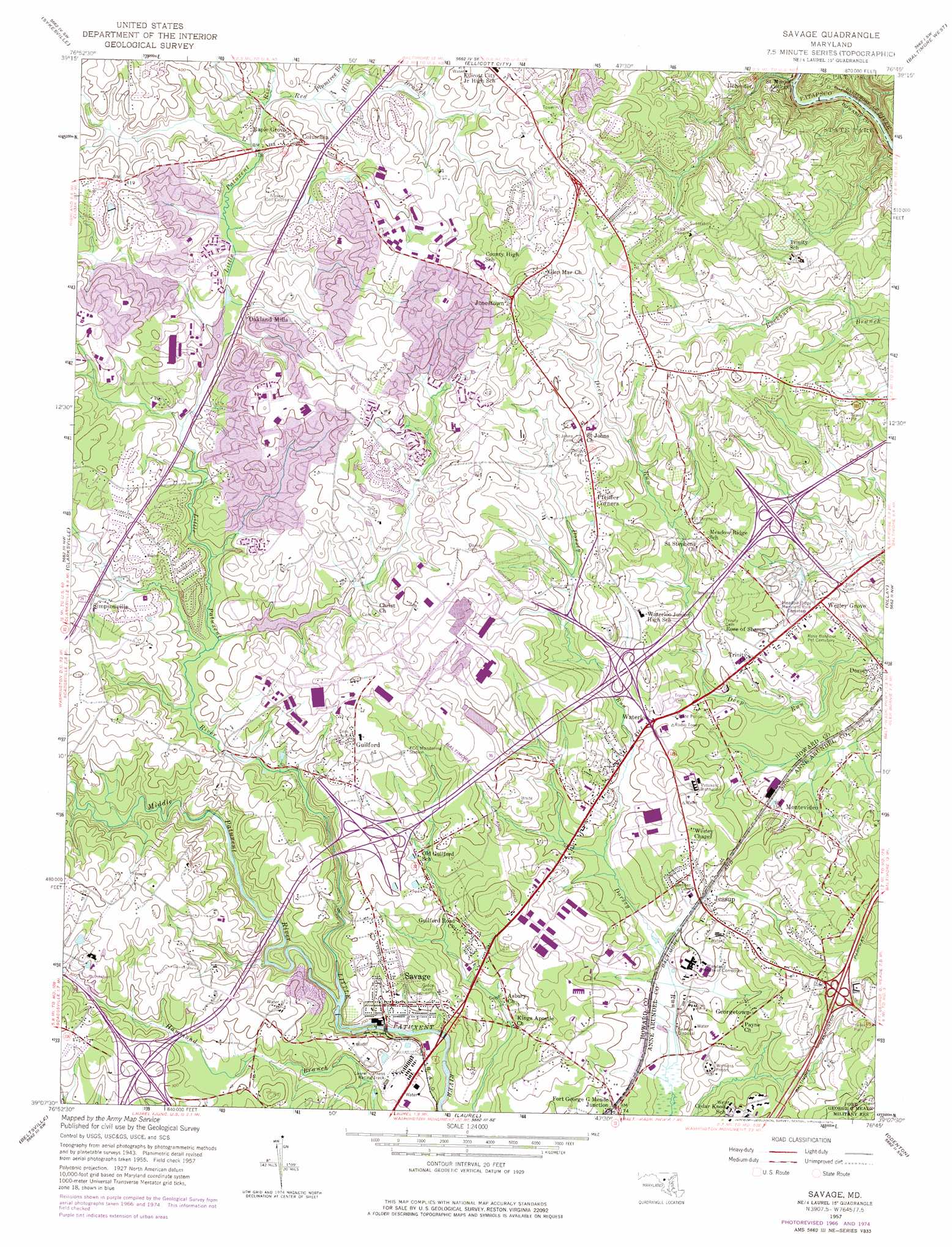
Savage Topo Map Maryland
To zoom in, hover over the map of Savage
USGS Topo Quad 39076b7 - 1:24,000 scale
| Topo Map Name: | Savage |
| USGS Topo Quad ID: | 39076b7 |
| Print Size: | ca. 21 1/4" wide x 27" high |
| Southeast Coordinates: | 39.125° N latitude / 76.75° W longitude |
| Map Center Coordinates: | 39.1875° N latitude / 76.8125° W longitude |
| U.S. State: | MD |
| Filename: | o39076b7.jpg |
| Download Map JPG Image: | Savage topo map 1:24,000 scale |
| Map Type: | Topographic |
| Topo Series: | 7.5´ |
| Map Scale: | 1:24,000 |
| Source of Map Images: | United States Geological Survey (USGS) |
| Alternate Map Versions: |
Savage MD 1950 Download PDF Buy paper map Savage MD 1950 Download PDF Buy paper map Savage MD 1957, updated 1960 Download PDF Buy paper map Savage MD 1957, updated 1965 Download PDF Buy paper map Savage MD 1957, updated 1967 Download PDF Buy paper map Savage MD 1957, updated 1976 Download PDF Buy paper map Savage MD 1957, updated 1976 Download PDF Buy paper map Savage MD 1957, updated 1976 Download PDF Buy paper map Savage MD 1981, updated 1986 Download PDF Buy paper map Savage MD 2011 Download PDF Buy paper map Savage MD 2014 Download PDF Buy paper map Savage MD 2016 Download PDF Buy paper map |
1:24,000 Topo Quads surrounding Savage
Winfield |
Finksburg |
Reisterstown |
Cockeysville |
Towson |
Woodbine |
Sykesville |
Ellicott City |
Baltimore West |
Baltimore East |
Sandy Spring |
Clarksville |
Savage |
Relay |
Curtis Bay |
Kensington |
Beltsville |
Laurel |
Odenton |
Round Bay |
Washington West |
Washington East |
Lanham |
Bowie |
South River |
> Back to 39076a1 at 1:100,000 scale
> Back to 39076a1 at 1:250,000 scale
> Back to U.S. Topo Maps home
Savage topo map: Gazetteer
Savage: Airports
Aerospace Tech Center Heliport elevation 126m 413′Savage: Bridges
Bollman Suspension and Trussed Bridge elevation 42m 137′Savage: Crossings
Interchange 35 elevation 109m 357′Interchange 38 elevation 100m 328′
Interchange 41 elevation 86m 282′
Interchange 43 elevation 78m 255′
Savage: Dams
Bloede Dam elevation 18m 59′Lake Elkhorn Dam elevation 89m 291′
Lake Kittamaqundi Dam elevation 113m 370′
Rocky Gorge Dam elevation 131m 429′
Savage Dam elevation 53m 173′
Savage: Parks
Atholton Park elevation 98m 321′Cedar-Villa Heights Park elevation 85m 278′
Centennial Park elevation 103m 337′
Dickinson Park elevation 95m 311′
Gorman Park elevation 83m 272′
Guilford Park elevation 85m 278′
Hopewell Park elevation 110m 360′
Jessup Park elevation 74m 242′
Kings Contrivance Park elevation 102m 334′
Long Reach Park elevation 127m 416′
Martin Road Park elevation 113m 370′
Rockburn Branch Park elevation 99m 324′
Savage Mill Historic District elevation 56m 183′
Savage Park elevation 87m 285′
Sewells Orchard Park elevation 111m 364′
Waterloo Park elevation 78m 255′
Wilde Lake Park elevation 98m 321′
Worthington Park elevation 147m 482′
Savage: Populated Places
Aladdin Village elevation 71m 232′Aladdin Village Trailer Park elevation 73m 239′
Allview Estates elevation 102m 334′
Annetta Gardens elevation 102m 334′
Arrowhead elevation 95m 311′
Asbury Woods elevation 69m 226′
Aspenwood elevation 84m 275′
Autumn Woods elevation 64m 209′
Barrington Woods elevation 156m 511′
Bonnie Acres elevation 134m 439′
Bonnie Brae elevation 145m 475′
Brampton Hills elevation 126m 413′
Brentwood Manor elevation 65m 213′
Bridewell (historical) elevation 51m 167′
Brightfield elevation 123m 403′
Bryant Woods elevation 121m 396′
Campbell elevation 65m 213′
Cardinal Forest elevation 110m 360′
Carriage Hills elevation 108m 354′
Cedars elevation 65m 213′
Centennial Lake elevation 131m 429′
Champion Forest elevation 73m 239′
Chase Eden elevation 104m 341′
Columbia elevation 124m 406′
Columbia Hills elevation 122m 400′
Corridor North elevation 57m 187′
Crowder elevation 148m 485′
Dasher Green elevation 98m 321′
Deep Run Park elevation 79m 259′
Deep Run Park elevation 87m 285′
Dickinson elevation 89m 291′
Donleigh elevation 104m 341′
Elkhorn elevation 97m 318′
Evemar Mobile Home Park elevation 74m 242′
Font Hill elevation 143m 469′
Fort George G Mead Junction elevation 57m 187′
Garrian Orchards elevation 159m 521′
Georgetown elevation 75m 246′
Glen Court elevation 65m 213′
Glen Oaks elevation 105m 344′
Glenmar elevation 146m 479′
Glenmont elevation 130m 426′
Glenshire Towne elevation 105m 344′
Guilford elevation 119m 390′
Guilford Downs elevation 118m 387′
Guilford Gardens elevation 118m 387′
Guilford Square elevation 116m 380′
Hammonds Promise elevation 87m 285′
Hanover Hills elevation 49m 160′
Heritage Woods elevation 91m 298′
Hopewell elevation 110m 360′
Howard Hills elevation 81m 265′
Hunt Country Estates elevation 124m 406′
Huntington elevation 109m 357′
Huntington East elevation 91m 298′
Jeffers Hill elevation 115m 377′
Jessup elevation 63m 206′
Jonestown elevation 155m 508′
Kings Meade elevation 113m 370′
Knollview elevation 141m 462′
Lakeview elevation 119m 390′
Lennox Park elevation 56m 183′
Lillys Addition elevation 123m 403′
Locust Manor elevation 111m 364′
Locust Park elevation 131m 429′
Long Reach elevation 129m 423′
MacGills Common elevation 103m 337′
Magnolia (historical) elevation 66m 216′
Maple Trailer Park elevation 64m 209′
Marshalee Estates elevation 79m 259′
Mayfield Manor elevation 79m 259′
Mission Heights elevation 99m 324′
Montevideo elevation 47m 154′
Montgomery Knolls elevation 120m 393′
Montgomery Run elevation 141m 462′
Nordeau elevation 86m 282′
North Laurel elevation 90m 295′
Oak View Village elevation 116m 380′
Oakland Mills elevation 113m 370′
Orange Grove (historical) elevation 9m 29′
Owen Brown elevation 110m 360′
Parkway Hills Mobile Home Park elevation 78m 255′
Peter Harmond Acres elevation 126m 413′
Pfeiffer Corners elevation 104m 341′
Phelps Luck elevation 140m 459′
Pleasant Grove elevation 117m 383′
Pleasant View elevation 116m 380′
River Island elevation 54m 177′
Robinsons Promise elevation 91m 298′
Rosemont elevation 120m 393′
Running Brook elevation 103m 337′
Savage elevation 64m 209′
Sebring elevation 116m 380′
Sewells Orchard elevation 114m 374′
Sharewood Acres elevation 69m 226′
Springwood elevation 63m 206′
Stevens Forest elevation 106m 347′
Stonebrook elevation 91m 298′
Talbott Springs elevation 115m 377′
Tall Pines Trailer Park elevation 81m 265′
The Birches elevation 121m 396′
The Pines elevation 88m 288′
Thompsons Purchase elevation 90m 295′
Thunder Hill elevation 119m 390′
Timber Run elevation 144m 472′
Valley View elevation 142m 465′
Vantage Point elevation 108m 354′
Villa Heights elevation 75m 246′
Village of Deep Run elevation 79m 259′
Village of Dorseys Search elevation 101m 331′
Wardens Landing elevation 132m 433′
Warfields Range elevation 113m 370′
Washington Manor elevation 80m 262′
Washington Manor Park elevation 60m 196′
Waterloo elevation 70m 229′
Wellington Estates elevation 117m 383′
Wesley Grove elevation 61m 200′
Wheatfield Way elevation 128m 419′
Whitehurst elevation 77m 252′
Woodland Village elevation 99m 324′
Woodleigh elevation 122m 400′
Woodvalley elevation 94m 308′
Worthington elevation 142m 465′
Savage: Post Offices
American Cities Post Office elevation 100m 328′Annapolis Junction Post Office elevation 61m 200′
Columbia Post Office elevation 120m 393′
Jessup Post Office elevation 86m 282′
Oakland Mills Post Office elevation 125m 410′
Savage Post Office elevation 60m 196′
Simpsonville Post Office elevation 103m 337′
Savage: Reservoirs
General Electric Retention Pond elevation 97m 318′Lake Elkhorn elevation 89m 291′
Lake Kittamaqundi elevation 88m 288′
Patapsco River Reservoir elevation 18m 59′
Wilde Lake elevation 125m 410′
Savage: Streams
Middle Patuxent River elevation 54m 177′Plumtree Branch elevation 97m 318′
Red Hill Branch elevation 96m 314′
Savage: Woods
Symphony Woods elevation 110m 360′Savage digital topo map on disk
Buy this Savage topo map showing relief, roads, GPS coordinates and other geographical features, as a high-resolution digital map file on DVD:
Atlantic Coast (NY, NJ, PA, DE, MD, VA, NC)
Buy digital topo maps: Atlantic Coast (NY, NJ, PA, DE, MD, VA, NC)
 map DVD")