Londonderry Topo Map Ohio
To zoom in, hover over the map of Londonderry
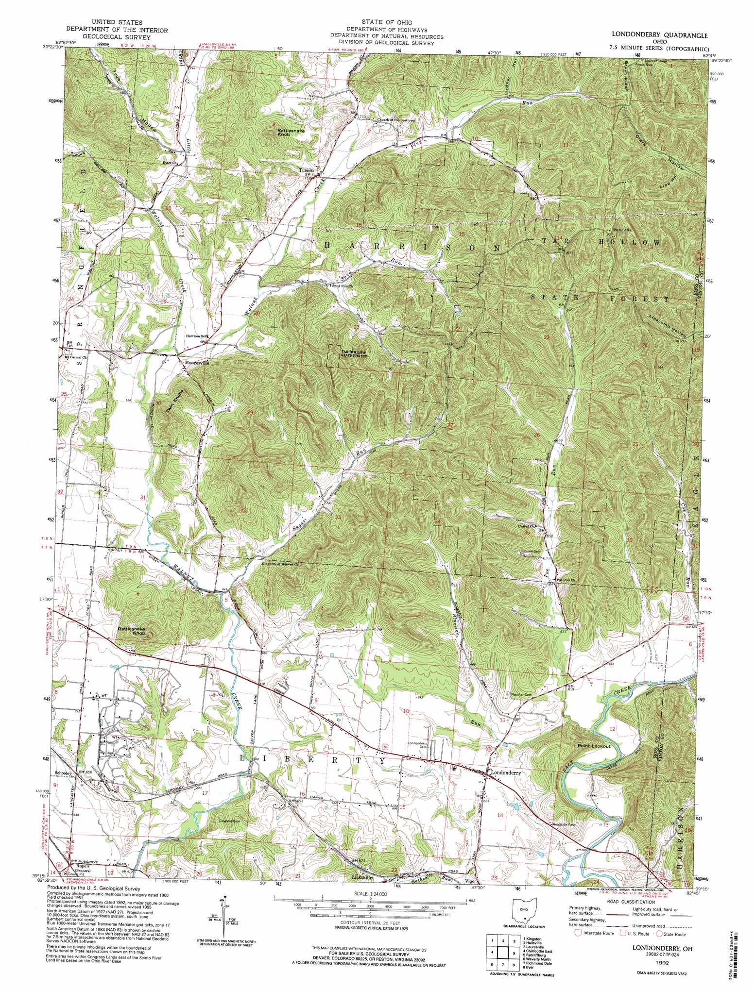
USGS Topo Quad 39082c7 - 1:24,000 scale
| Topo Map Name: | Londonderry |
| USGS Topo Quad ID: | 39082c7 |
| Print Size: | ca. 21 1/4" wide x 27" high |
| Southeast Coordinates: | 39.25° N latitude / 82.75° W longitude |
| Map Center Coordinates: | 39.3125° N latitude / 82.8125° W longitude |
| U.S. State: | OH |
| Filename: | o39082c7.jpg |
| Download Map JPG Image: | Londonderry topo map 1:24,000 scale |
| Map Type: | Topographic |
| Topo Series: | 7.5´ |
| Map Scale: | 1:24,000 |
| Source of Map Images: | United States Geological Survey (USGS) |
| Alternate Map Versions: |
Londonderry OH 1961, updated 1963 Download PDF Buy paper map Londonderry OH 1961, updated 1970 Download PDF Buy paper map Londonderry OH 1961, updated 1982 Download PDF Buy paper map Londonderry OH 1992, updated 1995 Download PDF Buy paper map Londonderry OH 2010 Download PDF Buy paper map Londonderry OH 2013 Download PDF Buy paper map Londonderry OH 2016 Download PDF Buy paper map |
1:24,000 Topo Quads surrounding Londonderry
Williamsport |
Circleville |
Stoutsville |
Clearport |
Rockbridge |
Andersonville |
Kingston |
Hallsville |
Laurelville |
South Bloomingville |
Chillicothe West |
Chillicothe East |
Londonderry |
Ratcliffburg |
Allensville |
Summithill |
Waverly North |
Richmond Dale |
Byer |
Hamden |
Piketon |
Waverly South |
Beaver |
Jackson |
Wellston |
> Back to 39082a1 at 1:100,000 scale
> Back to 39082a1 at 1:250,000 scale
> Back to U.S. Topo Maps home
Londonderry topo map: Gazetteer
Londonderry: Crossings
Jones Ford elevation 189m 620′Londonderry: Forests
Tar Hollow State Forest elevation 330m 1082′Londonderry: Populated Places
Charleston (historical) elevation 223m 731′Lickskillet elevation 198m 649′
Londonderry elevation 210m 688′
Mooresville elevation 208m 682′
Poe Valley (historical) elevation 200m 656′
Rupels elevation 195m 639′
Schooley elevation 195m 639′
Tucson elevation 219m 718′
Londonderry: Post Offices
Londonderry Post Office elevation 210m 688′Mooresville Post Office (historical) elevation 205m 672′
Schooley Post Office (historical) elevation 197m 646′
Tucson Post Office (historical) elevation 218m 715′
Londonderry: Streams
Bluelick Run elevation 183m 600′Chapel Creek elevation 217m 711′
Cox Run elevation 183m 600′
Cranberry Run elevation 192m 629′
Goshen Run elevation 189m 620′
Little Walnut Creek elevation 199m 652′
Piny Run elevation 214m 702′
Poe Run elevation 181m 593′
Spud Run elevation 207m 679′
Sugar Run elevation 195m 639′
Londonderry: Summits
Point Lookout elevation 289m 948′Rattlesnake Knob elevation 337m 1105′
Rattlesnake Knob elevation 322m 1056′
Twin Knobs elevation 322m 1056′
Londonderry: Valleys
Butcher Hollow elevation 244m 800′Frog Hollow elevation 246m 807′
True Hollow elevation 217m 711′
Londonderry digital topo map on disk
Buy this Londonderry topo map showing relief, roads, GPS coordinates and other geographical features, as a high-resolution digital map file on DVD:
 map DVD")