Springfield Topo Map Ohio
To zoom in, hover over the map of Springfield
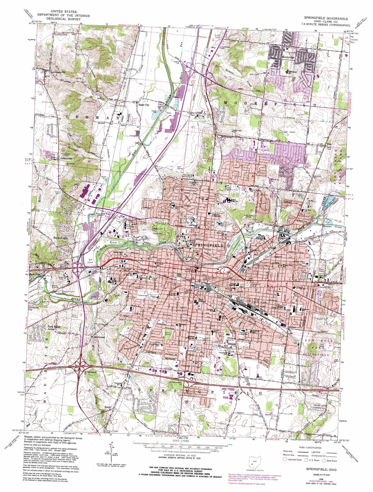
USGS Topo Quad 39083h7 - 1:24,000 scale
| Topo Map Name: | Springfield |
| USGS Topo Quad ID: | 39083h7 |
| Print Size: | ca. 21 1/4" wide x 27" high |
| Southeast Coordinates: | 39.875° N latitude / 83.75° W longitude |
| Map Center Coordinates: | 39.9375° N latitude / 83.8125° W longitude |
| U.S. State: | OH |
| Filename: | o39083h7.jpg |
| Download Map JPG Image: | Springfield topo map 1:24,000 scale |
| Map Type: | Topographic |
| Topo Series: | 7.5´ |
| Map Scale: | 1:24,000 |
| Source of Map Images: | United States Geological Survey (USGS) |
| Alternate Map Versions: |
Springfield OH 1955, updated 1956 Download PDF Buy paper map Springfield OH 1966, updated 1968 Download PDF Buy paper map Springfield OH 1966, updated 1974 Download PDF Buy paper map Springfield OH 1966, updated 1982 Download PDF Buy paper map Springfield OH 1966, updated 1988 Download PDF Buy paper map Springfield OH 2010 Download PDF Buy paper map Springfield OH 2013 Download PDF Buy paper map Springfield OH 2016 Download PDF Buy paper map |
1:24,000 Topo Quads surrounding Springfield
Fletcher |
Saint Paris |
Northville |
Kingscreek |
North Lewisburg |
Christiansburg |
Thackery |
Urbana West |
Urbana East |
Mechanicsburg |
New Carlisle |
Donnelsville |
Springfield |
New Moorefield |
South Vienna |
Fairborn |
Yellow Springs |
Clifton |
South Charleston |
Florence |
Bellbrook |
Xenia |
Cedarville |
Jamestown |
Jeffersonville |
> Back to 39083e1 at 1:100,000 scale
> Back to 39082a1 at 1:250,000 scale
> Back to U.S. Topo Maps home
Springfield topo map: Gazetteer
Springfield: Airports
Logans Chance Airport elevation 328m 1076′Springfield: Crossings
Interchange 52 elevation 295m 967′Interchange 54 elevation 311m 1020′
Springfield: Lakes
Culp Lake elevation 309m 1013′Springfield: Parks
Cliff Park elevation 283m 928′Crabill Fen Nature Preserve elevation 311m 1020′
Davey Moore Park elevation 303m 994′
East High Street Historic District elevation 301m 987′
Evans Stadium elevation 311m 1020′
Lagonda Field elevation 287m 941′
Lagonda Park elevation 285m 935′
Municipal Stadium elevation 285m 935′
New Reid Park elevation 331m 1085′
Old Reid Park elevation 293m 961′
Rose Street Park elevation 308m 1010′
Snyder Park elevation 275m 902′
South Fountain Avenue Historic District elevation 311m 1020′
Willa Park elevation 323m 1059′
Springfield: Populated Places
Beatty elevation 309m 1013′Belmont Meadows elevation 318m 1043′
Bon Air Mobile Home Park elevation 293m 961′
Cheviot Hills elevation 330m 1082′
Clearview Mobile Home Park elevation 293m 961′
Crabill Road Farms elevation 320m 1049′
Dal-Mar Mobile Home Park elevation 281m 921′
Eagle City elevation 282m 925′
Eastview Heights elevation 314m 1030′
Edgewood Farms elevation 319m 1046′
Forest Hills elevation 300m 984′
Glencoe Estates elevation 323m 1059′
Green Hedges elevation 319m 1046′
Greenlawn Village elevation 316m 1036′
Happy Valley Mobile Home Park elevation 281m 921′
Home Orchards elevation 323m 1059′
Jacksonville elevation 326m 1069′
Kenwood Heights elevation 315m 1033′
Kingsgate Commons elevation 311m 1020′
Lagonda elevation 292m 958′
Layne elevation 311m 1020′
Limecrest elevation 320m 1049′
Locustgrove elevation 317m 1040′
Meadow Lane elevation 329m 1079′
Melrose (historical) elevation 285m 935′
Miracle Mile elevation 316m 1036′
North Hill elevation 295m 967′
Northridge elevation 330m 1082′
Oakcrest elevation 305m 1000′
Oakwood Village elevation 323m 1059′
Olympic Hills elevation 323m 1059′
Park Ridge Acres elevation 309m 1013′
Possum Woods elevation 311m 1020′
Riceville (historical) elevation 310m 1017′
Ridgewood elevation 313m 1026′
Rolling Terrace Mobile Home Park elevation 321m 1053′
Rose Garden Mobile Home Park elevation 278m 912′
Seans Woods elevation 302m 990′
Shawnee Acres elevation 320m 1049′
Sherwood Park elevation 320m 1049′
Shoups Mobile Home Park elevation 315m 1033′
Snyder Terrace elevation 288m 944′
Snyders Mill elevation 300m 984′
Southgate elevation 306m 1003′
Southridge elevation 315m 1033′
Springfield elevation 298m 977′
Springfield Station (historical) elevation 278m 912′
Sun Valley elevation 313m 1026′
Sunnyland elevation 285m 935′
Terra Cella Manor elevation 305m 1000′
Upper Fox Hollow elevation 321m 1053′
Villa elevation 328m 1076′
Walnut Hills elevation 308m 1010′
Warder Park elevation 305m 1000′
Westridge elevation 330m 1082′
Springfield: Post Offices
Beatty Post Office (historical) elevation 309m 1013′Eagle City Post Office (historical) elevation 282m 925′
Lagonda Post Office (historical) elevation 292m 958′
Springfield Post Office elevation 289m 948′
Villa Post Office (historical) elevation 329m 1079′
Springfield: Streams
Beaver Creek elevation 289m 948′Buck Creek elevation 274m 898′
Dry Run elevation 285m 935′
Kenton Creek elevation 284m 931′
Mill Creek elevation 270m 885′
Moore Run elevation 280m 918′
Pondy Creek elevation 277m 908′
Rock Run elevation 269m 882′
Springfield: Trails
Buckhorn Trail elevation 322m 1056′Springfield: Woods
Perrin Woods elevation 310m 1017′Springfield digital topo map on disk
Buy this Springfield topo map showing relief, roads, GPS coordinates and other geographical features, as a high-resolution digital map file on DVD:
 map DVD")