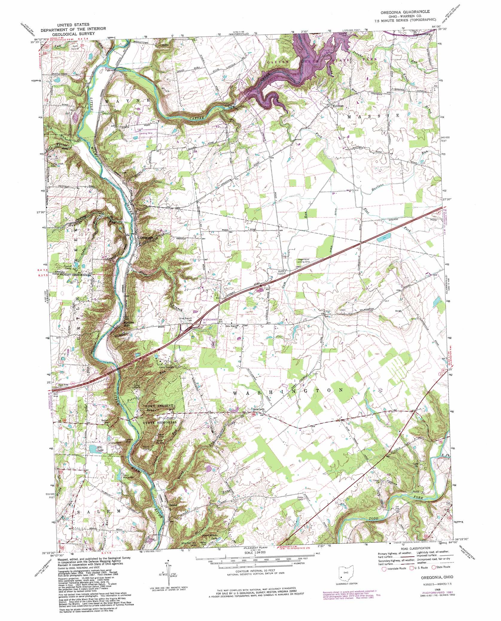
Oregonia Topo Map Ohio
To zoom in, hover over the map of Oregonia
USGS Topo Quad 39084d1 - 1:24,000 scale
| Topo Map Name: | Oregonia |
| USGS Topo Quad ID: | 39084d1 |
| Print Size: | ca. 21 1/4" wide x 27" high |
| Southeast Coordinates: | 39.375° N latitude / 84° W longitude |
| Map Center Coordinates: | 39.4375° N latitude / 84.0625° W longitude |
| U.S. State: | OH |
| Filename: | o39084d1.jpg |
| Download Map JPG Image: | Oregonia topo map 1:24,000 scale |
| Map Type: | Topographic |
| Topo Series: | 7.5´ |
| Map Scale: | 1:24,000 |
| Source of Map Images: | United States Geological Survey (USGS) |
| Alternate Map Versions: |
Oregonia OH 1955, updated 1956 Download PDF Buy paper map Oregonia OH 1955, updated 1964 Download PDF Buy paper map Oregonia OH 1968, updated 1970 Download PDF Buy paper map Oregonia OH 1968, updated 1976 Download PDF Buy paper map Oregonia OH 1968, updated 1982 Download PDF Buy paper map Oregonia OH 1996, updated 1999 Download PDF Buy paper map Oregonia OH 2011 Download PDF Buy paper map Oregonia OH 2013 Download PDF Buy paper map Oregonia OH 2016 Download PDF Buy paper map |
1:24,000 Topo Quads surrounding Oregonia
Miamisburg |
Dayton South |
Bellbrook |
Xenia |
Cedarville |
Franklin |
Springboro |
Waynesville |
New Burlington |
Port William |
Monroe |
Lebanon |
Oregonia |
Clarksville |
Wilmington |
Mason |
South Lebanon |
Pleasant Plain |
Blanchester |
Martinsville |
Madeira |
Goshen |
Newtonsville |
Fayetteville |
Lynchburg |
> Back to 39084a1 at 1:100,000 scale
> Back to 39084a1 at 1:250,000 scale
> Back to U.S. Topo Maps home
Oregonia topo map: Gazetteer
Oregonia: Airports
Caesar Creek Gliderport elevation 284m 931′Hagemeyer Airport elevation 286m 938′
Oregonia: Bridges
Jeremiah Morrow Bridge elevation 201m 659′Oregonia: Crossings
Interchange 36 elevation 292m 958′Oregonia: Dams
Elk Lake Dam elevation 279m 915′Gray Pond Dam elevation 279m 915′
Harper Pond Dam elevation 253m 830′
Murphy Pond Dam elevation 278m 912′
Oregonia: Lakes
Four Winds Lake elevation 276m 905′Oregonia: Parks
Caesar Creek Gorge State Natural Area elevation 220m 721′Caesar Creek State Park elevation 256m 839′
Fort Ancient State Memorial elevation 282m 925′
Oregonia: Populated Places
Mathers Mills elevation 206m 675′Oregonia elevation 211m 692′
Senior elevation 213m 698′
Usrey Mobile Home Park elevation 296m 971′
Wellman elevation 287m 941′
Oregonia: Reservoirs
Caesar Creek Lake elevation 245m 803′Elk Lake elevation 279m 915′
Gray Pond elevation 279m 915′
Harper Pond elevation 253m 830′
Murphy Pond elevation 278m 912′
Oregonia: Streams
Caesar Creek elevation 213m 698′Cedar Branch elevation 226m 741′
Cowen Run elevation 207m 679′
Dry Run elevation 213m 698′
East Fork Todd Fork elevation 246m 807′
East Turtle Creek elevation 210m 688′
Fall Run elevation 213m 698′
Ferris Run elevation 201m 659′
Flat Fork elevation 278m 912′
Gum Run elevation 278m 912′
Harlans Run elevation 277m 908′
Hawleys Run elevation 208m 682′
Jonahs Run elevation 267m 875′
Knoll Brook elevation 269m 882′
Olive Branch elevation 208m 682′
Randall Run elevation 204m 669′
Richs Run elevation 274m 898′
Stony Run elevation 201m 659′
Oregonia digital topo map on disk
Buy this Oregonia topo map showing relief, roads, GPS coordinates and other geographical features, as a high-resolution digital map file on DVD:
Northern Illinois, Northern Indiana & Southwestern Michigan
Buy digital topo maps: Northern Illinois, Northern Indiana & Southwestern Michigan