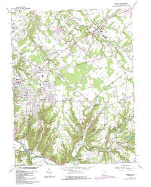
Goshen Topo Map Ohio
To zoom in, hover over the map of Goshen
USGS Topo Quad 39084b2 - 1:24,000 scale
| Topo Map Name: | Goshen |
| USGS Topo Quad ID: | 39084b2 |
| Print Size: | ca. 21 1/4" wide x 27" high |
| Southeast Coordinates: | 39.125° N latitude / 84.125° W longitude |
| Map Center Coordinates: | 39.1875° N latitude / 84.1875° W longitude |
| U.S. State: | OH |
| Filename: | o39084b2.jpg |
| Download Map JPG Image: | Goshen topo map 1:24,000 scale |
| Map Type: | Topographic |
| Topo Series: | 7.5´ |
| Map Scale: | 1:24,000 |
| Source of Map Images: | United States Geological Survey (USGS) |
| Alternate Map Versions: |
Goshen OH 1953, updated 1955 Download PDF Buy paper map Goshen OH 1965, updated 1967 Download PDF Buy paper map Goshen OH 1965, updated 1976 Download PDF Buy paper map Goshen OH 1965, updated 1987 Download PDF Buy paper map Goshen OH 2010 Download PDF Buy paper map Goshen OH 2013 Download PDF Buy paper map Goshen OH 2016 Download PDF Buy paper map |
1:24,000 Topo Quads surrounding Goshen
> Back to 39084a1 at 1:100,000 scale
> Back to 39084a1 at 1:250,000 scale
> Back to U.S. Topo Maps home
Goshen topo map: Gazetteer
Goshen: Airports
Goshen International Airport elevation 250m 820′Goshen: Bridges
Stonelick-Perintown Bridge elevation 174m 570′Goshen: Dams
Heritage Lake Dam elevation 226m 741′Sumner Pond Dam elevation 241m 790′
Syrian Shrine Oasis Lake Dam elevation 253m 830′
Wiemeyer Pond Dam elevation 250m 820′
Goshen: Lakes
Cedar Lakes elevation 260m 853′Hill Lakes elevation 269m 882′
Mueller Lake elevation 252m 826′
Orchard Lake elevation 249m 816′
Red R Lake elevation 268m 879′
White Gables Lakes elevation 267m 875′
Goshen: Parks
Longfield Acres Park elevation 268m 879′Miami Meadow Park elevation 269m 882′
Goshen: Populated Places
Ashdale elevation 266m 872′Belfast elevation 271m 889′
Craver elevation 180m 590′
Day Heights elevation 263m 862′
Elenor elevation 268m 879′
Goshen elevation 255m 836′
Mount Repose elevation 263m 862′
Mulberry elevation 256m 839′
Perintown elevation 160m 524′
Springvale elevation 257m 843′
Williams Corners elevation 264m 866′
Goshen: Post Offices
Belfast Post Office (historical) elevation 271m 889′Craver Post Office (historical) elevation 181m 593′
Elenor Post Office (historical) elevation 268m 879′
Goshen Post Office elevation 255m 836′
Mount Repose Post Office (historical) elevation 263m 862′
Mulberry Post Office (historical) elevation 257m 843′
Perintown Post Office (historical) elevation 160m 524′
Goshen: Reservoirs
Fairacres Lake elevation 262m 859′Heritage Lake elevation 226m 741′
Sumner Pond elevation 241m 790′
Wiemeyer Pond elevation 250m 820′
Goshen: Streams
Brushy Fork elevation 195m 639′Dry Run elevation 158m 518′
Indiancamp Creek elevation 250m 820′
Lick Fork elevation 177m 580′
Rocky Run elevation 207m 679′
Salt Run elevation 158m 518′
Shayler Run elevation 157m 515′
Sugarcamp Run elevation 160m 524′
Wolfpen Run elevation 157m 515′
Goshen: Summits
Galley Hill elevation 265m 869′Goshen digital topo map on disk
Buy this Goshen topo map showing relief, roads, GPS coordinates and other geographical features, as a high-resolution digital map file on DVD:
Northern Illinois, Northern Indiana & Southwestern Michigan
Buy digital topo maps: Northern Illinois, Northern Indiana & Southwestern Michigan


