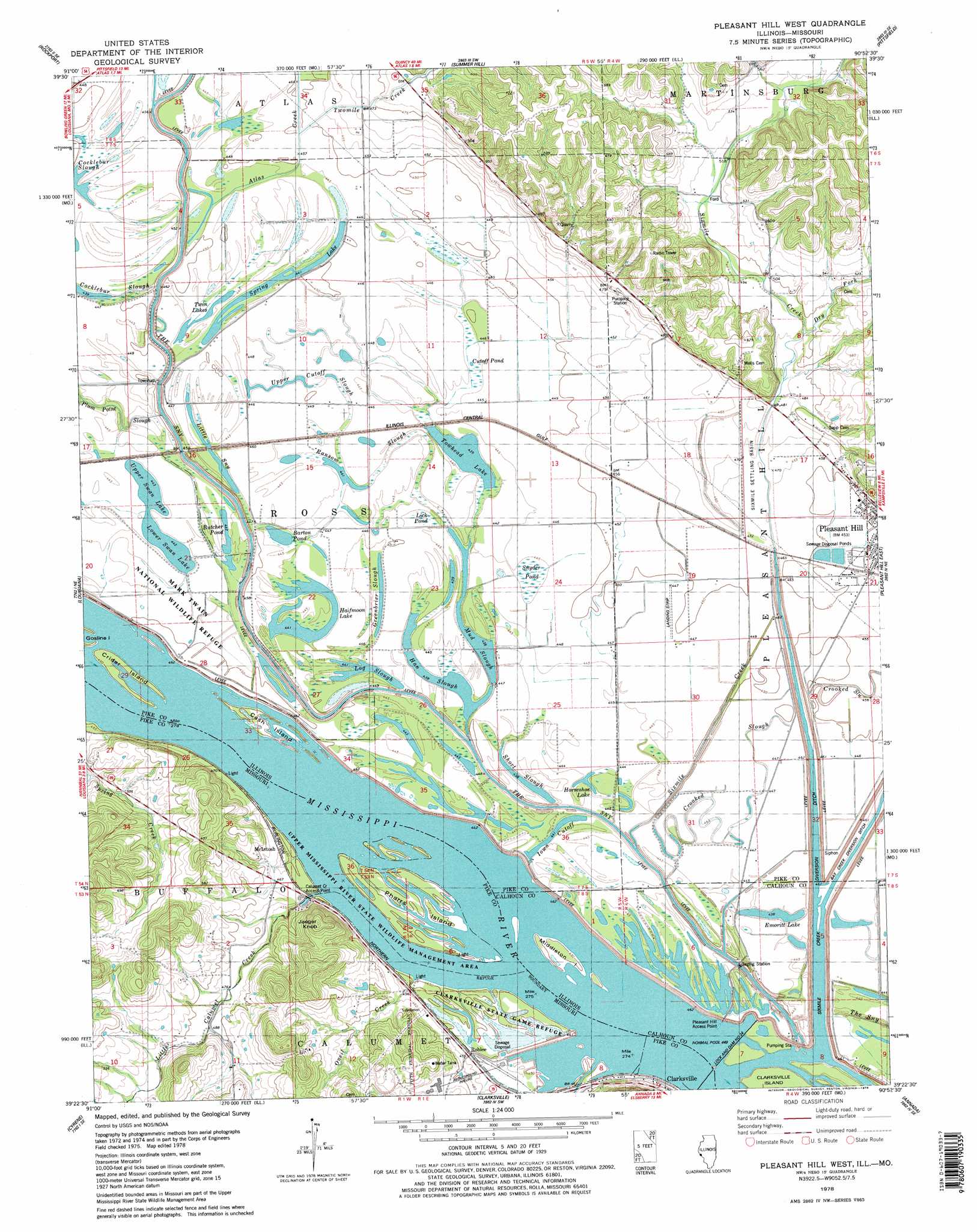
Pleasant Hill West Topo Map Illinois
To zoom in, hover over the map of Pleasant Hill West
USGS Topo Quad 39090d8 - 1:24,000 scale
| Topo Map Name: | Pleasant Hill West |
| USGS Topo Quad ID: | 39090d8 |
| Print Size: | ca. 21 1/4" wide x 27" high |
| Southeast Coordinates: | 39.375° N latitude / 90.875° W longitude |
| Map Center Coordinates: | 39.4375° N latitude / 90.9375° W longitude |
| U.S. States: | IL, MO |
| Filename: | o39090d8.jpg |
| Download Map JPG Image: | Pleasant Hill West topo map 1:24,000 scale |
| Map Type: | Topographic |
| Topo Series: | 7.5´ |
| Map Scale: | 1:24,000 |
| Source of Map Images: | United States Geological Survey (USGS) |
| Alternate Map Versions: |
Pleasant Hill West IL 1978, updated 1978 Download PDF Buy paper map Pleasant Hill West IL 1978, updated 1978 Download PDF Buy paper map Pleasant Hill West IL 1993, updated 1996 Download PDF Buy paper map Pleasant Hill West IL 2012 Download PDF Buy paper map Pleasant Hill West IL 2015 Download PDF Buy paper map |
1:24,000 Topo Quads surrounding Pleasant Hill West
Hull |
Barry |
Baylis |
New Salem |
Griggsville |
Ashburn |
Rockport |
Summer Hill |
Pittsfield |
Milton |
Vera |
Louisana |
Pleasant Hill West |
Pleasant Hill East |
Pearl West |
Bowling Green |
Cyrene |
Clarksville |
Annada |
Pleasant Dale Valley |
Louisville |
Eolia |
Auburn |
Elsberry |
Hamburg |
> Back to 39090a1 at 1:100,000 scale
> Back to 39090a1 at 1:250,000 scale
> Back to U.S. Topo Maps home
Pleasant Hill West topo map: Gazetteer
Pleasant Hill West: Basins
Sixmile Settling Basin elevation 139m 456′Pleasant Hill West: Canals
Sixmile Creek Diversion Ditch elevation 134m 439′Pleasant Hill West: Dams
Lock and Dam 24 elevation 136m 446′Lock and Dam Number 24 elevation 134m 439′
Mononame 149 Dam elevation 164m 538′
Pleasant Hill West: Guts
Greenbrier Slough elevation 136m 446′Han Slough elevation 133m 436′
Iowa Cutoff elevation 134m 439′
Little Sny elevation 134m 439′
Mud Slough elevation 133m 436′
Ransom Slough elevation 136m 446′
Upper Cutoff Slough elevation 136m 446′
Pleasant Hill West: Islands
Cash Island elevation 137m 449′Crider Island elevation 137m 449′
Middleton Island elevation 137m 449′
Pharrs Island elevation 137m 449′
Spring Lake Island elevation 136m 446′
Pleasant Hill West: Lakes
Barton Pond elevation 136m 446′Butcher Pond elevation 136m 446′
Cutoff Pond elevation 136m 446′
Emoritt Lake elevation 134m 439′
Halfmoon Lake elevation 134m 439′
Horseshoe Lake elevation 134m 439′
Log Slough elevation 134m 439′
Lower Swan Lake elevation 135m 442′
Short Slough elevation 133m 436′
Spring Lake elevation 134m 439′
Towhead Lake elevation 134m 439′
Twin Lakes elevation 136m 446′
Upper Swan Lake elevation 135m 442′
Pleasant Hill West: Parks
Clarksville State Game Refuge elevation 137m 449′Pleasant Hill West: Populated Places
McIntosh elevation 155m 508′Roblee elevation 139m 456′
Pleasant Hill West: Reservoirs
Pool 24 elevation 136m 446′Pleasant Hill West: Streams
Atlas Creek elevation 136m 446′Calumet Creek elevation 137m 449′
Dry Fork elevation 146m 479′
Little Calumet Creek elevation 137m 449′
Oneil Creek elevation 137m 449′
Sixmile Creek elevation 133m 436′
Twomile Creek elevation 137m 449′
Pleasant Hill West: Summits
Jaeger Knob elevation 230m 754′Pleasant Hill West: Swamps
Lick Pond elevation 136m 446′Snyder Pond elevation 135m 442′
Pleasant Hill West digital topo map on disk
Buy this Pleasant Hill West topo map showing relief, roads, GPS coordinates and other geographical features, as a high-resolution digital map file on DVD: