Griggsville Topo Map Illinois
To zoom in, hover over the map of Griggsville
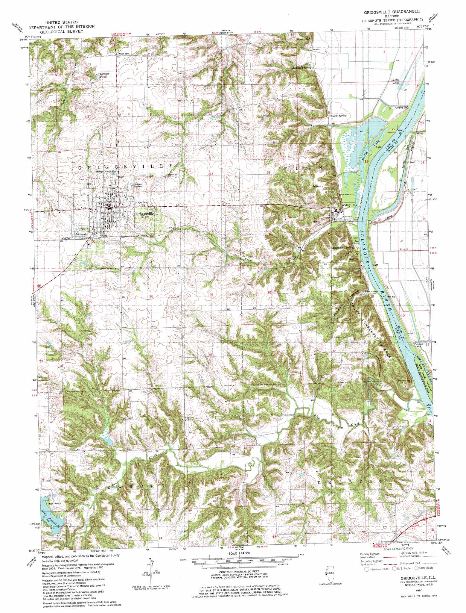
USGS Topo Quad 39090f6 - 1:24,000 scale
| Topo Map Name: | Griggsville |
| USGS Topo Quad ID: | 39090f6 |
| Print Size: | ca. 21 1/4" wide x 27" high |
| Southeast Coordinates: | 39.625° N latitude / 90.625° W longitude |
| Map Center Coordinates: | 39.6875° N latitude / 90.6875° W longitude |
| U.S. State: | IL |
| Filename: | o39090f6.jpg |
| Download Map JPG Image: | Griggsville topo map 1:24,000 scale |
| Map Type: | Topographic |
| Topo Series: | 7.5´ |
| Map Scale: | 1:24,000 |
| Source of Map Images: | United States Geological Survey (USGS) |
| Alternate Map Versions: |
Griggsville IL 1980, updated 1981 Download PDF Buy paper map Griggsville IL 1998, updated 2001 Download PDF Buy paper map Griggsville IL 2012 Download PDF Buy paper map Griggsville IL 2015 Download PDF Buy paper map |
1:24,000 Topo Quads surrounding Griggsville
Kellerville |
Mount Sterling |
Versailles |
Cooperstown |
Arenzville West |
Fishhook |
Perry West |
Perry East |
Meredosia |
Chapin |
Baylis |
New Salem |
Griggsville |
Florence |
Winchester |
Summer Hill |
Pittsfield |
Milton |
Bedford |
Alsey |
Pleasant Hill West |
Pleasant Hill East |
Pearl West |
Pearl East |
Roodhouse West |
> Back to 39090e1 at 1:100,000 scale
> Back to 39090a1 at 1:250,000 scale
> Back to U.S. Topo Maps home
Griggsville topo map: Gazetteer
Griggsville: Airports
Curry Airport elevation 190m 623′Griggsville: Crossings
Phillips Ferry (historical) elevation 130m 426′Griggsville: Dams
New Pittsfield Lake Number 1 Dam elevation 174m 570′New Pittsfield Lake Number 2 Dam elevation 158m 518′
Griggsville: Islands
Big Blue Island elevation 131m 429′Griggsville: Lakes
Boss Wilson Pond (historical) elevation 189m 620′Burr Lake (historical) elevation 130m 426′
McCoe Lake elevation 133m 436′
Shelly Lake elevation 131m 429′
Shelly Lake elevation 131m 429′
Sleight Pond elevation 184m 603′
Griggsville: Mines
Valley City Quarry elevation 163m 534′Griggsville: Parks
Griggsville Historic District elevation 217m 711′Pike County Conservation Area elevation 196m 643′
Griggsville: Populated Places
Griggsville elevation 215m 705′Valley City elevation 150m 492′
Griggsville: Reservoirs
Lake Pittsfield elevation 183m 600′New Pittsfield Lake Number 1 elevation 174m 570′
New Pittsfield Lake Number 2 elevation 158m 518′
Griggsville: Springs
Anderson Spring elevation 137m 449′Winegar Spring elevation 137m 449′
Griggsville: Streams
Blue Creek elevation 131m 429′Flint Creek elevation 131m 429′
Mauvaise Terre Creek elevation 130m 426′
Griggsville: Valleys
Church Hollow elevation 139m 456′Napolean Hollow elevation 134m 439′
Griggsville digital topo map on disk
Buy this Griggsville topo map showing relief, roads, GPS coordinates and other geographical features, as a high-resolution digital map file on DVD: