Hull Topo Map Illinois
To zoom in, hover over the map of Hull
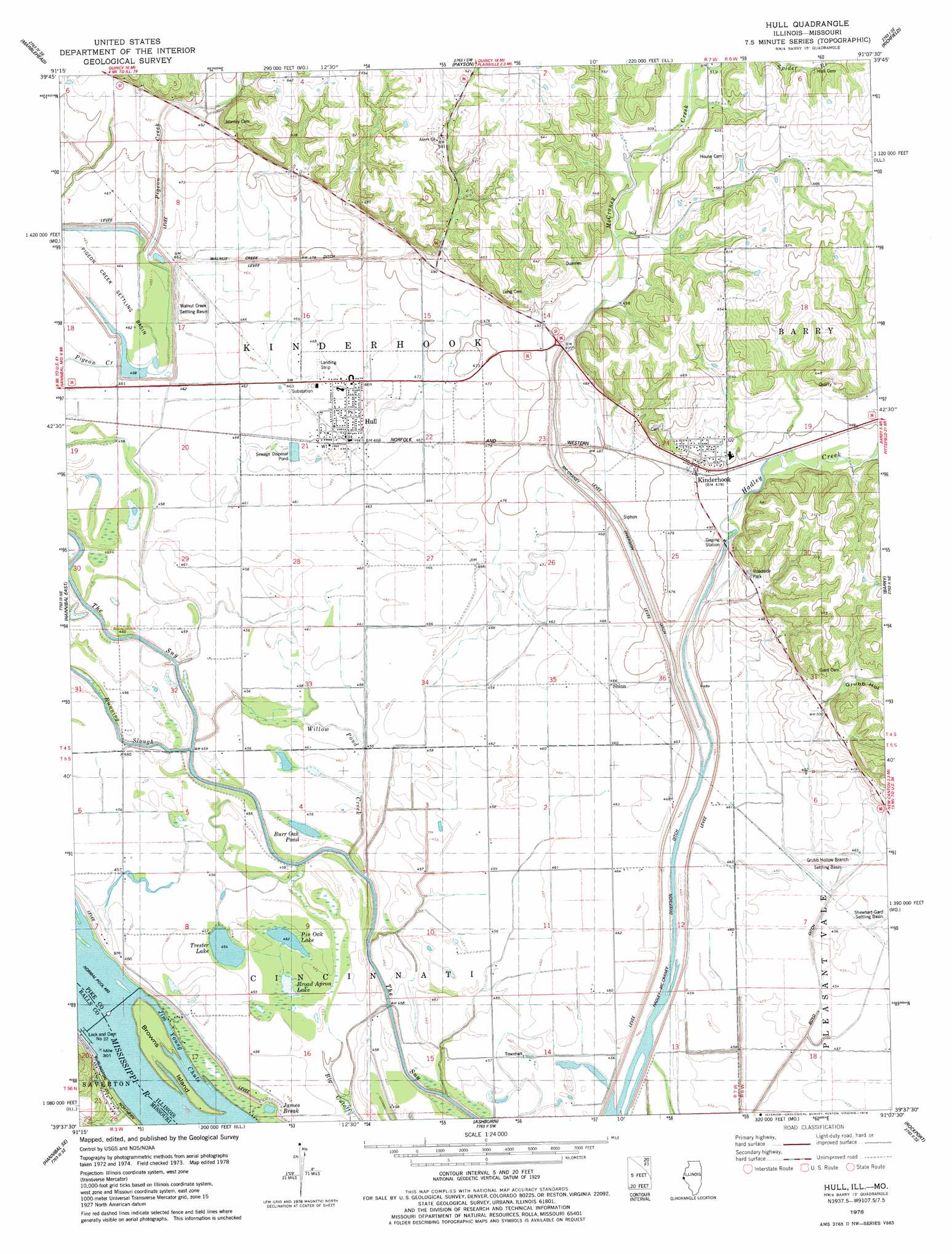
USGS Topo Quad 39091f2 - 1:24,000 scale
| Topo Map Name: | Hull |
| USGS Topo Quad ID: | 39091f2 |
| Print Size: | ca. 21 1/4" wide x 27" high |
| Southeast Coordinates: | 39.625° N latitude / 91.125° W longitude |
| Map Center Coordinates: | 39.6875° N latitude / 91.1875° W longitude |
| U.S. States: | IL, MO |
| Filename: | o39091f2.jpg |
| Download Map JPG Image: | Hull topo map 1:24,000 scale |
| Map Type: | Topographic |
| Topo Series: | 7.5´ |
| Map Scale: | 1:24,000 |
| Source of Map Images: | United States Geological Survey (USGS) |
| Alternate Map Versions: |
Hull IL 1978, updated 1978 Download PDF Buy paper map Hull IL 1993, updated 1996 Download PDF Buy paper map Hull IL 2012 Download PDF Buy paper map Hull IL 2015 Download PDF Buy paper map |
1:24,000 Topo Quads surrounding Hull
Quincy West |
Quincy East |
Columbus |
Liberty |
Kellerville |
Quincy Sw |
Marblehead |
Payson |
Richfield |
Fishhook |
Hannibal West |
Hannibal East |
Hull |
Barry |
Baylis |
New London |
Hannibal Se |
Ashburn |
Rockport |
Summer Hill |
Spencerburg |
Frankford |
Vera |
Louisana |
Pleasant Hill West |
> Back to 39091e1 at 1:100,000 scale
> Back to 39090a1 at 1:250,000 scale
> Back to U.S. Topo Maps home
Hull topo map: Gazetteer
Hull: Airports
Hull Airport elevation 142m 465′Hull: Basins
Grubb Hollow Branch Settling Basin elevation 139m 456′Pigeon Creek Settling Basin elevation 141m 462′
Shewhart-Gard Settling Basin elevation 139m 456′
Walnut Creek Settling Basin elevation 139m 456′
Hull: Canals
Boyd Ditch elevation 139m 456′Hadley-McCraney Diversion Ditch elevation 138m 452′
McCraney Diversion Ditch elevation 141m 462′
Walnut Creek Ditch elevation 144m 472′
Hull: Crossings
Interchange 10 elevation 145m 475′Hull: Dams
Lock and Dam Number 22 elevation 142m 465′Lock and Dam Number 22 elevation 142m 465′
Lock and Dam Number Twenty-two elevation 141m 462′
Hull: Islands
Browns Island elevation 142m 465′Hull: Lakes
Broad Apron Lake elevation 138m 452′Burr Oak Pond elevation 138m 452′
Eagle Pond (historical) elevation 137m 449′
James Break elevation 140m 459′
Pin Oak Lake elevation 137m 449′
Trester Lake elevation 139m 456′
Willow Pond elevation 138m 452′
Hull: Parks
Grubb Hollow Prairie Nature Preserve elevation 214m 702′Hull: Populated Places
Hull elevation 143m 469′Kinderhook elevation 148m 485′
Shinn elevation 142m 465′
Hull: Reservoirs
Pool Number 22 elevation 142m 465′Hull: Streams
Hadley Creek elevation 140m 459′Jim Young Chute elevation 137m 449′
McCraney Creek elevation 140m 459′
Spider Branch elevation 156m 511′
Willow Pond Creek elevation 140m 459′
Hull: Valleys
Grubb Hollow elevation 150m 492′Hull digital topo map on disk
Buy this Hull topo map showing relief, roads, GPS coordinates and other geographical features, as a high-resolution digital map file on DVD: