Quaker Mesa Topo Map Colorado
To zoom in, hover over the map of Quaker Mesa
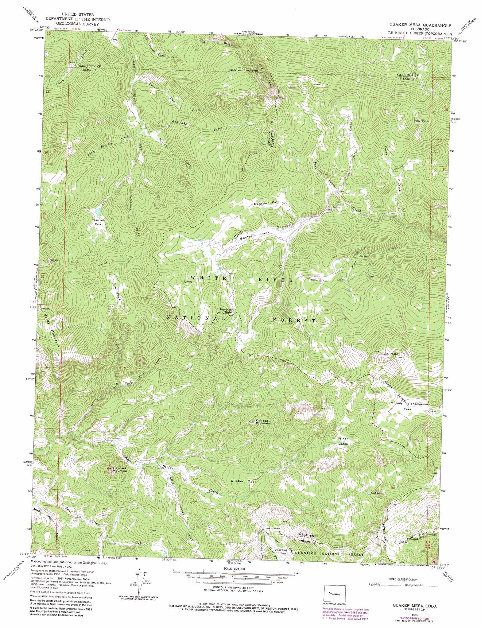
USGS Topo Quad 39107c4 - 1:24,000 scale
| Topo Map Name: | Quaker Mesa |
| USGS Topo Quad ID: | 39107c4 |
| Print Size: | ca. 21 1/4" wide x 27" high |
| Southeast Coordinates: | 39.25° N latitude / 107.375° W longitude |
| Map Center Coordinates: | 39.3125° N latitude / 107.4375° W longitude |
| U.S. State: | CO |
| Filename: | o39107c4.jpg |
| Download Map JPG Image: | Quaker Mesa topo map 1:24,000 scale |
| Map Type: | Topographic |
| Topo Series: | 7.5´ |
| Map Scale: | 1:24,000 |
| Source of Map Images: | United States Geological Survey (USGS) |
| Alternate Map Versions: |
Quaker Mesa CO 1963, updated 1967 Download PDF Buy paper map Quaker Mesa CO 1963, updated 1967 Download PDF Buy paper map Quaker Mesa CO 1963, updated 1978 Download PDF Buy paper map Quaker Mesa CO 1963, updated 1984 Download PDF Buy paper map Quaker Mesa CO 1963, updated 1988 Download PDF Buy paper map Quaker Mesa CO 2011 Download PDF Buy paper map Quaker Mesa CO 2013 Download PDF Buy paper map Quaker Mesa CO 2016 Download PDF Buy paper map |
| FStopo: | US Forest Service topo Quaker Mesa is available: Download FStopo PDF Download FStopo TIF |
1:24,000 Topo Quads surrounding Quaker Mesa
Silt |
New Castle |
Storm King Mountain |
Glenwood Springs |
Shoshone |
Hunter Mesa |
Gibson Gulch |
Center Mountain |
Cattle Creek |
Carbondale |
Hightower Mountain |
Flatiron Mountain |
Quaker Mesa |
Stony Ridge |
Mount Sopris |
Porter Mountain |
Spruce Mountain |
Elk Knob |
Placita |
Redstone |
Chalk Mountain |
Electric Mountain |
Bull Mountain |
Chair Mountain |
Marble |
> Back to 39107a1 at 1:100,000 scale
> Back to 39106a1 at 1:250,000 scale
> Back to U.S. Topo Maps home
Quaker Mesa topo map: Gazetteer
Quaker Mesa: Basins
Miner Basin elevation 2962m 9717′Quaker Mesa: Canals
Clear Fork Ditch elevation 2929m 9609′Thompson Creek Ditch elevation 2993m 9819′
Quaker Mesa: Cliffs
The Slides elevation 2953m 9688′Quaker Mesa: Flats
Baylor Park elevation 2845m 9333′Elk Park elevation 2788m 9146′
Mancon Park elevation 2889m 9478′
Middle Thompson Park elevation 3044m 9986′
Reservoir Park elevation 2764m 9068′
Quaker Mesa: Gaps
Haystack Gate elevation 2963m 9721′Quaker Mesa: Reservoirs
Lost Lake elevation 3202m 10505′Quaker Mesa: Streams
Beaver Dam Creek elevation 2575m 8448′Corral Creek elevation 2698m 8851′
Dry Rock Creek elevation 2588m 8490′
East Park Creek elevation 2796m 9173′
Gennings Creek elevation 2694m 8838′
Ginright Creek elevation 2627m 8618′
Lava Boulder Creek elevation 2630m 8628′
Little Beaver Creek elevation 2567m 8421′
Little Rock Creek elevation 2463m 8080′
Park Creek elevation 2783m 9130′
Willow Creek elevation 2621m 8599′
Wolf Creek elevation 2714m 8904′
Quaker Mesa: Summits
Baldy Mountain elevation 3114m 10216′Flat Top Mountain elevation 2894m 9494′
Haystack Mountain elevation 2762m 9061′
Quaker Mesa elevation 2734m 8969′
Twin Peaks elevation 3285m 10777′
Quaker Mesa digital topo map on disk
Buy this Quaker Mesa topo map showing relief, roads, GPS coordinates and other geographical features, as a high-resolution digital map file on DVD: