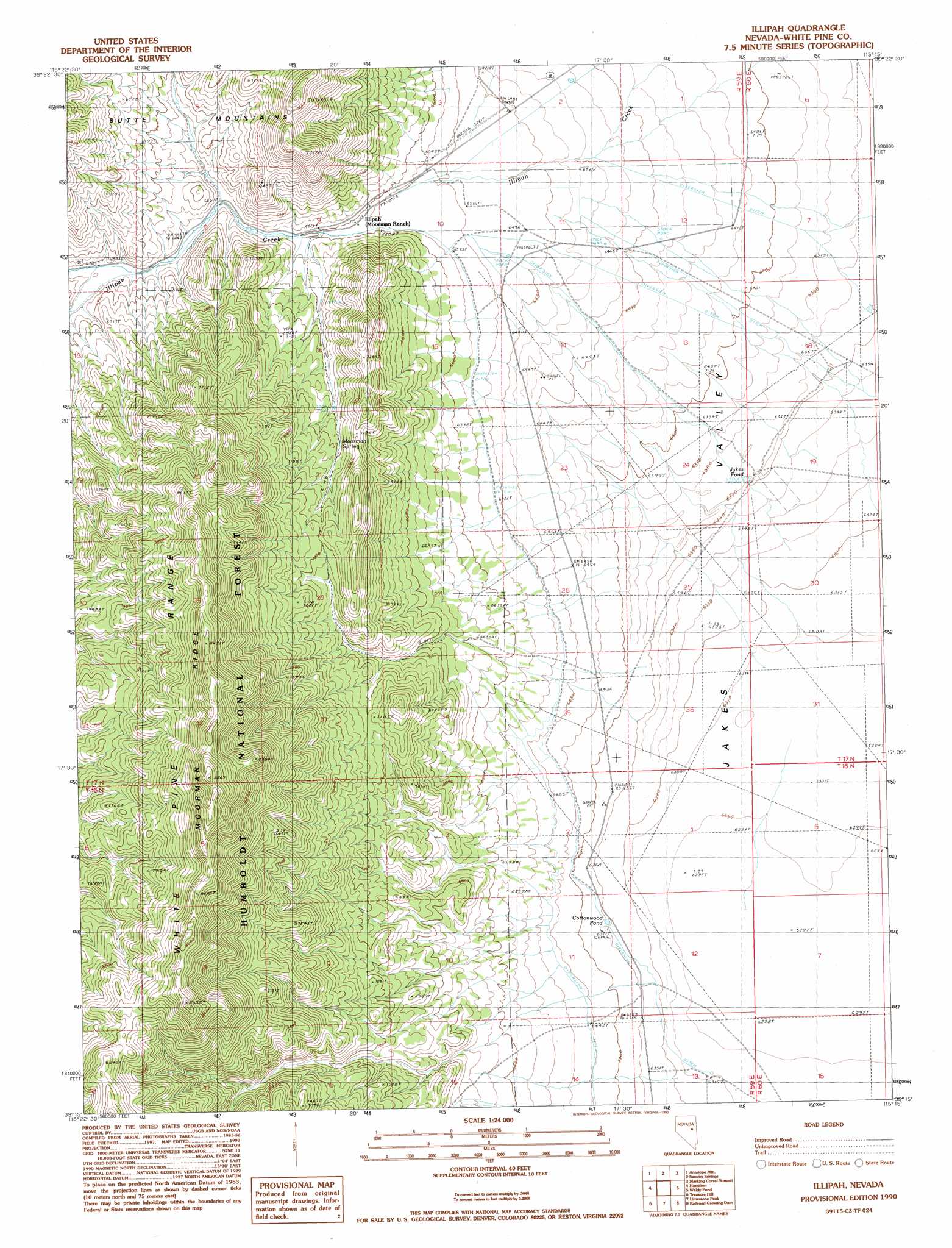
Illipah Topo Map Nevada
To zoom in, hover over the map of Illipah
USGS Topo Quad 39115c3 - 1:24,000 scale
| Topo Map Name: | Illipah |
| USGS Topo Quad ID: | 39115c3 |
| Print Size: | ca. 21 1/4" wide x 27" high |
| Southeast Coordinates: | 39.25° N latitude / 115.25° W longitude |
| Map Center Coordinates: | 39.3125° N latitude / 115.3125° W longitude |
| U.S. State: | NV |
| Filename: | o39115c3.jpg |
| Download Map JPG Image: | Illipah topo map 1:24,000 scale |
| Map Type: | Topographic |
| Topo Series: | 7.5´ |
| Map Scale: | 1:24,000 |
| Source of Map Images: | United States Geological Survey (USGS) |
| Alternate Map Versions: |
Illipah NV 1990, updated 1990 Download PDF Buy paper map Illipah NV 2012 Download PDF Buy paper map Illipah NV 2014 Download PDF Buy paper map |
| FStopo: | US Forest Service topo Illipah is available: Download FStopo PDF Download FStopo TIF |
1:24,000 Topo Quads surrounding Illipah
Beck Pass |
Sunshine Well |
Dickenson Well |
Thirtymile Ranch |
Combs Creek |
East Of Pancake Summit |
Antelope Mountain |
Sammys Springs |
Marking Corral Summit |
Robinson Summit |
Seligman Canyon |
Hamilton |
Illipah |
Waldy Pond |
Riepetown |
Mount Hamilton |
Treasure Hill |
Limestone Peak |
Railroad Crossing Dam |
Giroux Wash |
Green Springs |
Indian Garden Mountain |
Easter Springs |
Blackjack Springs |
Preston Reservoir |
> Back to 39115a1 at 1:100,000 scale
> Back to 39114a1 at 1:250,000 scale
> Back to U.S. Topo Maps home
Illipah topo map: Gazetteer
Illipah: Airports
Moorman Ranch Airport elevation 1986m 6515′Illipah: Lakes
Cottonwood Pond elevation 1940m 6364′Jakes Pond elevation 1943m 6374′
Illipah: Populated Places
Illipah (historical) elevation 2027m 6650′Illipah: Post Offices
Illipah Post Office (historical) elevation 2027m 6650′Illipah: Ridges
Moorman Ridge elevation 2617m 8585′Illipah: Springs
Moorman Spring elevation 2109m 6919′Illipah: Streams
Halstead Creek elevation 2040m 6692′Illipah digital topo map on disk
Buy this Illipah topo map showing relief, roads, GPS coordinates and other geographical features, as a high-resolution digital map file on DVD: