Norden Topo Map California
To zoom in, hover over the map of Norden
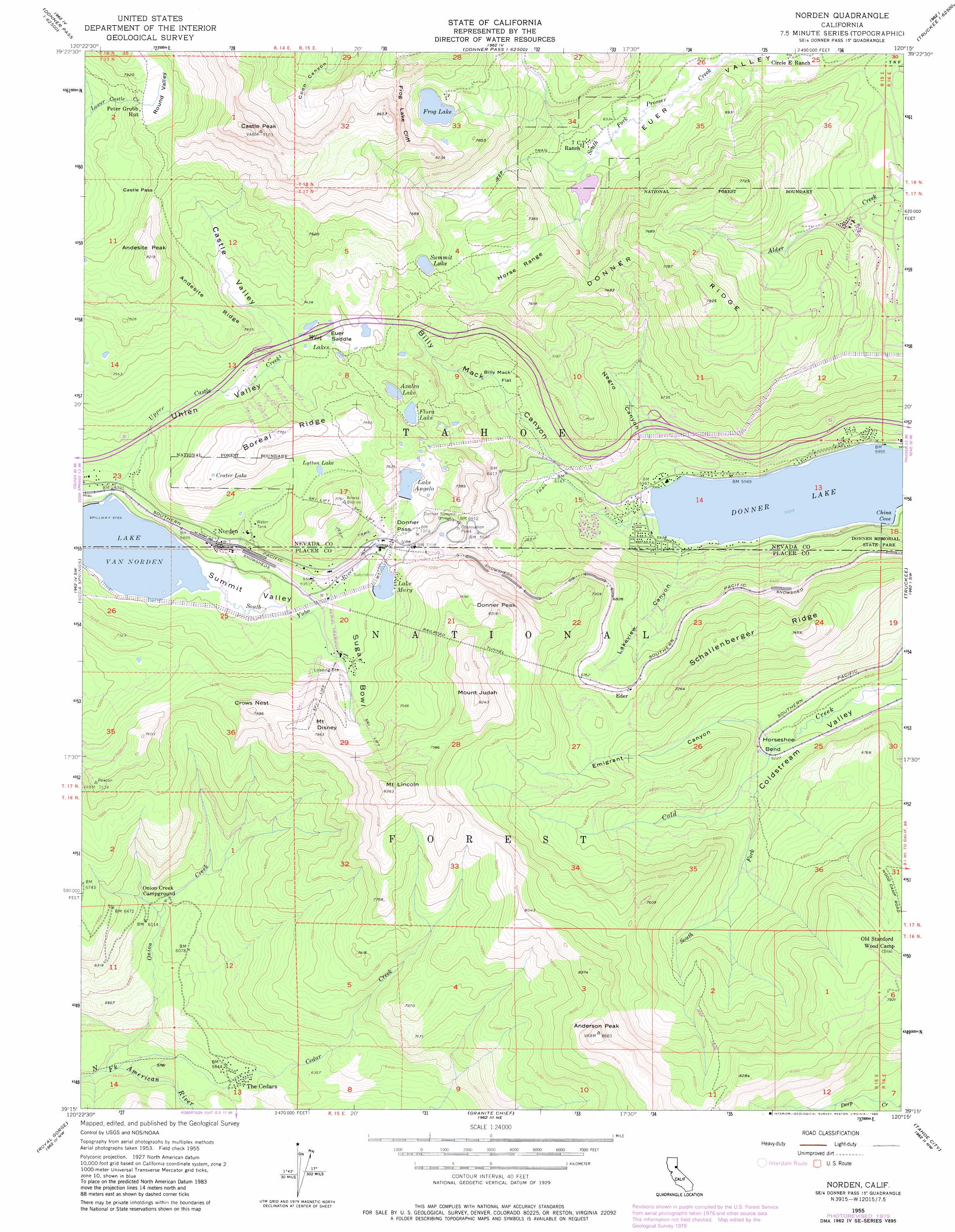
USGS Topo Quad 39120c3 - 1:24,000 scale
| Topo Map Name: | Norden |
| USGS Topo Quad ID: | 39120c3 |
| Print Size: | ca. 21 1/4" wide x 27" high |
| Southeast Coordinates: | 39.25° N latitude / 120.25° W longitude |
| Map Center Coordinates: | 39.3125° N latitude / 120.3125° W longitude |
| U.S. State: | CA |
| Filename: | o39120c3.jpg |
| Download Map JPG Image: | Norden topo map 1:24,000 scale |
| Map Type: | Topographic |
| Topo Series: | 7.5´ |
| Map Scale: | 1:24,000 |
| Source of Map Images: | United States Geological Survey (USGS) |
| Alternate Map Versions: |
Norden CA 1955, updated 1957 Download PDF Buy paper map Norden CA 1955, updated 1961 Download PDF Buy paper map Norden CA 1955, updated 1973 Download PDF Buy paper map Norden CA 1955, updated 1980 Download PDF Buy paper map Norden CA 1955, updated 1980 Download PDF Buy paper map Norden CA 2000, updated 2003 Download PDF Buy paper map Norden CA 2012 Download PDF Buy paper map Norden CA 2015 Download PDF Buy paper map |
| FStopo: | US Forest Service topo Norden is available: Download FStopo PDF Download FStopo TIF |
1:24,000 Topo Quads surrounding Norden
Haypress Valley |
Sattley |
Sierraville |
Sardine Peak |
Dog Valley |
English Mountain |
Webber Peak |
Independence Lake |
Hobart Mills |
Boca |
Cisco Grove |
Soda Springs |
Norden |
Truckee |
Martis Peak |
Duncan Peak |
Royal Gorge |
Granite Chief |
Tahoe City |
Kings Beach |
Greek Store |
Bunker Hill |
Wentworth Springs |
Homewood |
Meeks Bay |
> Back to 39120a1 at 1:100,000 scale
> Back to 39120a1 at 1:250,000 scale
> Back to U.S. Topo Maps home
Norden topo map: Gazetteer
Norden: Basins
Round Valley elevation 2388m 7834′Sugar Bowl elevation 2158m 7080′
Norden: Bays
China Cove elevation 1810m 5938′Norden: Bends
Horseshoe Bend elevation 1896m 6220′Norden: Bridges
Donner Summit Bridge elevation 2096m 6876′Norden: Cliffs
Frog Lake Cliff elevation 2448m 8031′Norden: Dams
Donner Ever Valley 319 Dam elevation 2006m 6581′Lake Angela 89-002 Dam elevation 2186m 7171′
Lake Mary 311-003 Dam elevation 2141m 7024′
Norden: Flats
Billy Mack Flat elevation 1974m 6476′Norden: Forests
Onion Creek Experimental Forest elevation 1964m 6443′Norden: Gaps
Castle Pass elevation 2413m 7916′Donner Pass elevation 2162m 7093′
Euer Saddle elevation 2207m 7240′
Norden: Lakes
Azalea Lake elevation 2192m 7191′Crater Lake elevation 2301m 7549′
Donner Lake elevation 1810m 5938′
Flora Lake elevation 2190m 7185′
Frog Lake elevation 2314m 7591′
Lytton Lake elevation 2226m 7303′
Summit Lake elevation 2255m 7398′
West Lakes elevation 2205m 7234′
Norden: Parks
West End Beach Park elevation 1812m 5944′Norden: Populated Places
Andover (historical) elevation 1921m 6302′Donner elevation 2140m 7020′
Donner Lake Village elevation 1814m 5951′
Donner Woods elevation 1814m 5951′
Eder elevation 2058m 6751′
Gelatt elevation 1812m 5944′
Lakeview elevation 1847m 6059′
Norden elevation 2115m 6938′
Southside Highlands elevation 1861m 6105′
Stanford (historical) elevation 1902m 6240′
The Cedars elevation 1764m 5787′
Weeks Tract elevation 1824m 5984′
Norden: Post Offices
Gelatt Post Office (historical) elevation 1812m 5944′Norden Post Office elevation 2140m 7020′
Norden: Ranges
Horse Range elevation 2168m 7112′Norden: Reservoirs
Lake Angela elevation 2186m 7171′Lake Mary elevation 2141m 7024′
Norden: Ridges
Andesite Ridge elevation 2504m 8215′Boreal Ridge elevation 2342m 7683′
Donner Ridge elevation 2294m 7526′
Schallenberger Ridge elevation 2185m 7168′
Norden: Streams
Cedar Creek elevation 1633m 5357′Onion Creek elevation 1633m 5357′
South Fork Cold Creek elevation 1900m 6233′
Upper Castle Creek elevation 2064m 6771′
Norden: Summits
Anderson Peak elevation 2646m 8681′Andesite Peak elevation 2504m 8215′
Castle Peak elevation 2773m 9097′
Crows Nest elevation 2404m 7887′
Donner Peak elevation 2435m 7988′
George R. Stewart Peak elevation 2237m 7339′
McGlashan Point elevation 2098m 6883′
Mount Disney elevation 2421m 7942′
Mount Judah elevation 2513m 8244′
Mount Lincoln elevation 2551m 8369′
Mount Stephens elevation 2211m 7253′
Norden: Valleys
Billy Mack Canyon elevation 1813m 5948′Castle Valley elevation 2202m 7224′
Emigrant Canyon elevation 1903m 6243′
Lakeview Canyon elevation 1818m 5964′
Negro Canyon elevation 1827m 5994′
Summit Valley elevation 2064m 6771′
Uhlen Valley elevation 2073m 6801′
Norden digital topo map on disk
Buy this Norden topo map showing relief, roads, GPS coordinates and other geographical features, as a high-resolution digital map file on DVD: