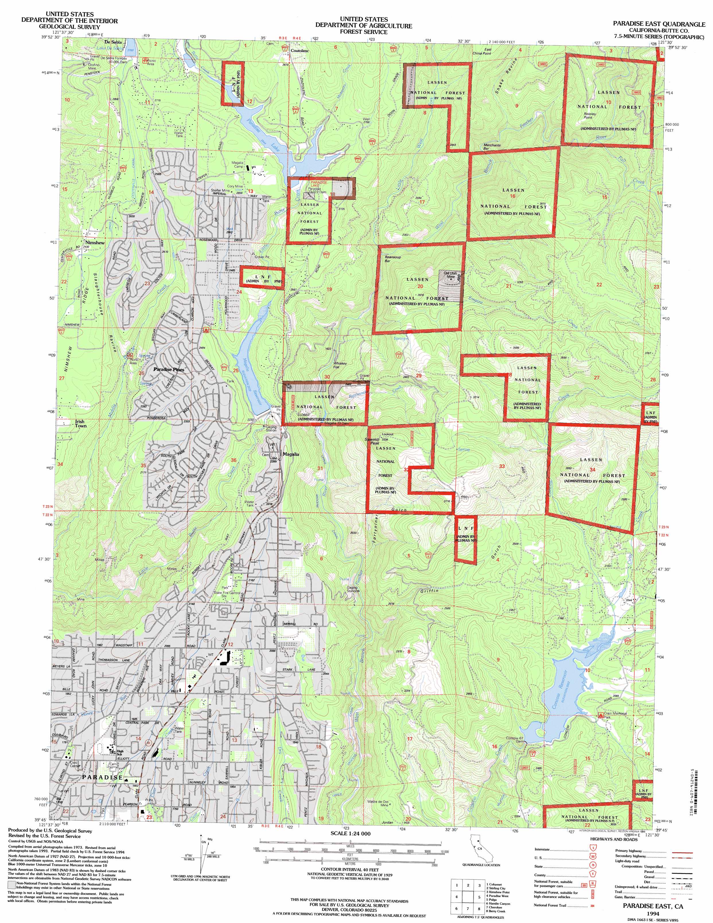
Paradise East Topo Map California
To zoom in, hover over the map of Paradise East
USGS Topo Quad 39121g5 - 1:24,000 scale
| Topo Map Name: | Paradise East |
| USGS Topo Quad ID: | 39121g5 |
| Print Size: | ca. 21 1/4" wide x 27" high |
| Southeast Coordinates: | 39.75° N latitude / 121.5° W longitude |
| Map Center Coordinates: | 39.8125° N latitude / 121.5625° W longitude |
| U.S. State: | CA |
| Filename: | o39121g5.jpg |
| Download Map JPG Image: | Paradise East topo map 1:24,000 scale |
| Map Type: | Topographic |
| Topo Series: | 7.5´ |
| Map Scale: | 1:24,000 |
| Source of Map Images: | United States Geological Survey (USGS) |
| Alternate Map Versions: |
Paradise East CA 1980, updated 1980 Download PDF Buy paper map Paradise East CA 1994, updated 1998 Download PDF Buy paper map Paradise East CA 2012 Download PDF Buy paper map Paradise East CA 2015 Download PDF Buy paper map |
| FStopo: | US Forest Service topo Paradise East is available: Download FStopo PDF Download FStopo TIF |
1:24,000 Topo Quads surrounding Paradise East
Ishi Caves |
Devils Parade Ground |
Butte Meadows |
Jonesville |
Belden |
Campbell Mound |
Cohasset |
Stirling City |
Kimshew Point |
Storrie |
Richardson Springs |
Paradise West |
Paradise East |
Pulga |
Soapstone Hill |
Chico |
Hamlin Canyon |
Cherokee |
Berry Creek |
Brush Creek |
Nelson |
Shippee |
Oroville |
Oroville Dam |
Forbestown |
> Back to 39121e1 at 1:100,000 scale
> Back to 39120a1 at 1:250,000 scale
> Back to U.S. Topo Maps home
Paradise East topo map: Gazetteer
Paradise East: Bars
Beansoup Bar elevation 616m 2020′Merchants Bar elevation 607m 1991′
Paradise East: Cliffs
East China Point elevation 976m 3202′Paradise East: Dams
Concow 67 Dam elevation 611m 2004′Desabla Forebay 97-005 Dam elevation 845m 2772′
Magalia 73 Dam elevation 677m 2221′
Paradise 73-002 Dam elevation 784m 2572′
Paradise East: Flats
Whiskey Flat elevation 482m 1581′Paradise East: Lakes
Paradise Lake elevation 784m 2572′Paradise East: Mines
Cory Mine elevation 813m 2667′Emma Mine elevation 697m 2286′
Genil Mine elevation 485m 1591′
Madre de Oro Mine elevation 581m 1906′
Magalia Mine elevation 778m 2552′
Old Utah Mine elevation 957m 3139′
Orofino Mine elevation 695m 2280′
Steifer Mine elevation 796m 2611′
Paradise East: Parks
Crain Memorial Park elevation 642m 2106′Paradise Memorial Park elevation 523m 1715′
Paradise East: Populated Places
De Sabla elevation 842m 2762′DeSabla elevation 796m 2611′
Magalia elevation 711m 2332′
Mineral Slide elevation 335m 1099′
Nimshew elevation 764m 2506′
Paradise elevation 542m 1778′
Paradise Pines elevation 745m 2444′
Paradise East: Post Offices
Magalia Post Office elevation 732m 2401′Paradise Post Office elevation 527m 1729′
Paradise East: Reservoirs
Concow Reservoir elevation 611m 2004′Lake De Sabla elevation 842m 2762′
Magalia Reservoir elevation 677m 2221′
Paradise East: Streams
Cirby Creek elevation 619m 2030′Empire Creek elevation 521m 1709′
Fall Creek elevation 717m 2352′
Little West Fork West Branch Feather River elevation 548m 1797′
Mosquito Creek elevation 771m 2529′
Rattlesnake Creek elevation 496m 1627′
Paradise East: Summits
Nimshew Ridge elevation 723m 2372′Robley Point elevation 882m 2893′
Sawmill Peak elevation 1004m 3293′
Paradise East: Valleys
Fortyniner Gulch elevation 456m 1496′Griffin Gulch elevation 435m 1427′
Shake Ravine elevation 630m 2066′
Slaughterhouse Ravine elevation 605m 1984′
Paradise East digital topo map on disk
Buy this Paradise East topo map showing relief, roads, GPS coordinates and other geographical features, as a high-resolution digital map file on DVD: