Saint James Topo Map New York
To zoom in, hover over the map of Saint James
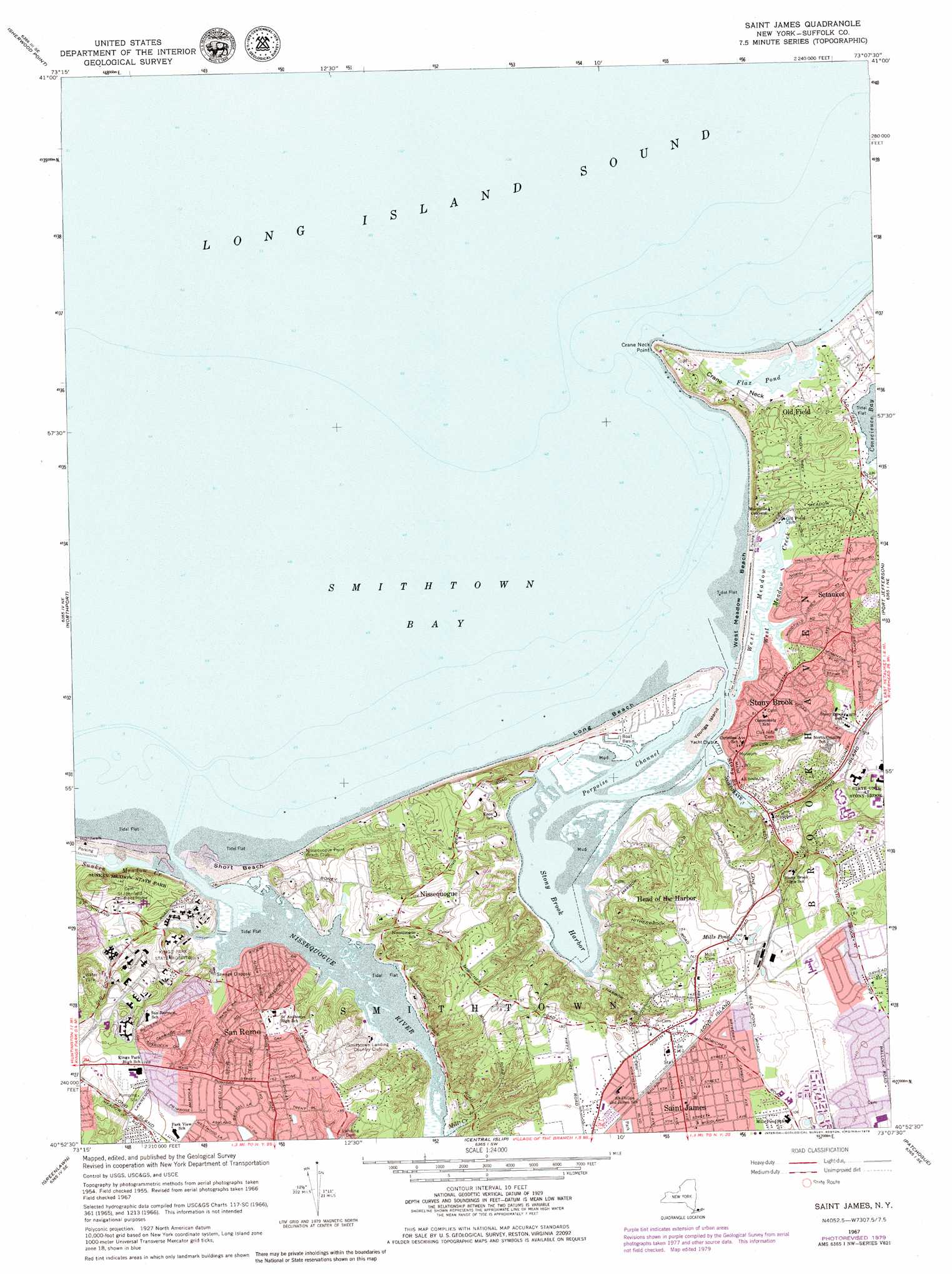
USGS Topo Quad 40073h2 - 1:24,000 scale
| Topo Map Name: | Saint James |
| USGS Topo Quad ID: | 40073h2 |
| Print Size: | ca. 21 1/4" wide x 27" high |
| Southeast Coordinates: | 40.875° N latitude / 73.125° W longitude |
| Map Center Coordinates: | 40.9375° N latitude / 73.1875° W longitude |
| U.S. State: | NY |
| Filename: | o40073h2.jpg |
| Download Map JPG Image: | Saint James topo map 1:24,000 scale |
| Map Type: | Topographic |
| Topo Series: | 7.5´ |
| Map Scale: | 1:24,000 |
| Source of Map Images: | United States Geological Survey (USGS) |
| Alternate Map Versions: |
St James NY 1947 Download PDF Buy paper map St James NY 1947 Download PDF Buy paper map Saint James NY 1955, updated 1963 Download PDF Buy paper map Saint James NY 1967, updated 1969 Download PDF Buy paper map Saint James NY 1967, updated 1979 Download PDF Buy paper map Saint James NY 2011 Download PDF Buy paper map Saint James NY 2013 Download PDF Buy paper map Saint James NY 2016 Download PDF Buy paper map |
1:24,000 Topo Quads surrounding Saint James
Norwalk North |
Westport |
Bridgeport |
Milford |
Woodmont |
Norwalk South |
Sherwood Point |
|||
Lloyd Harbor |
Northport |
Saint James |
Port Jefferson |
Middle Island |
Huntington |
Greenlawn |
Central Islip |
Patchogue |
Bellport |
Amityville |
Bay Shore West |
Bay Shore East |
Sayville |
Howells Point |
> Back to 40073e1 at 1:100,000 scale
> Back to 40072a1 at 1:250,000 scale
> Back to U.S. Topo Maps home
Saint James topo map: Gazetteer
Saint James: Airports
Flowerfield Airport (historical) elevation 49m 160′Saint James: Bays
Smithtown Bay elevation 0m 0′Saint James: Beaches
Long Beach elevation 3m 9′Short Beach elevation 0m 0′
West Meadow Beach elevation 1m 3′
Saint James: Capes
Crane Neck elevation 7m 22′Crane Neck Point elevation 21m 68′
Nissequogue Neck elevation 35m 114′
Saint James: Channels
Porpoise Channel elevation 0m 0′Saint James: Guts
Mill Creek elevation 2m 6′West Meadow Creek elevation 0m 0′
Saint James: Harbors
Stony Brook Harbor elevation 0m 0′Saint James: Islands
Youngs Island elevation 1m 3′Saint James: Lakes
Flax Pond elevation -1m -4′Mills Pond elevation 45m 147′
Saint James: Parks
Gaynor Park elevation 47m 154′Harrison Pond Park elevation 4m 13′
Little Africa Town Park elevation 5m 16′
Long Beach Town Park elevation 7m 22′
Olson Memorial Town Park elevation 37m 121′
West Meadow Beach Historic District elevation 0m 0′
West Meadow Wetlands Reserve elevation 1m 3′
Saint James: Populated Places
Head of the Harbor elevation 37m 121′Nissequogue elevation 26m 85′
Old Field elevation 2m 6′
Saint James elevation 46m 150′
San Remo elevation 49m 160′
Stony Brook elevation 27m 88′
Saint James: Post Offices
Stony Brook Post Office elevation 10m 32′Saint James: Streams
Nissequogue River elevation 0m 0′Stony Brook elevation 0m 0′
Sunken Meadow Creek elevation 0m 0′
Saint James: Swamps
West Meadow elevation 0m 0′Saint James digital topo map on disk
Buy this Saint James topo map showing relief, roads, GPS coordinates and other geographical features, as a high-resolution digital map file on DVD:
Atlantic Coast (NY, NJ, PA, DE, MD, VA, NC)
Buy digital topo maps: Atlantic Coast (NY, NJ, PA, DE, MD, VA, NC)
 map DVD")