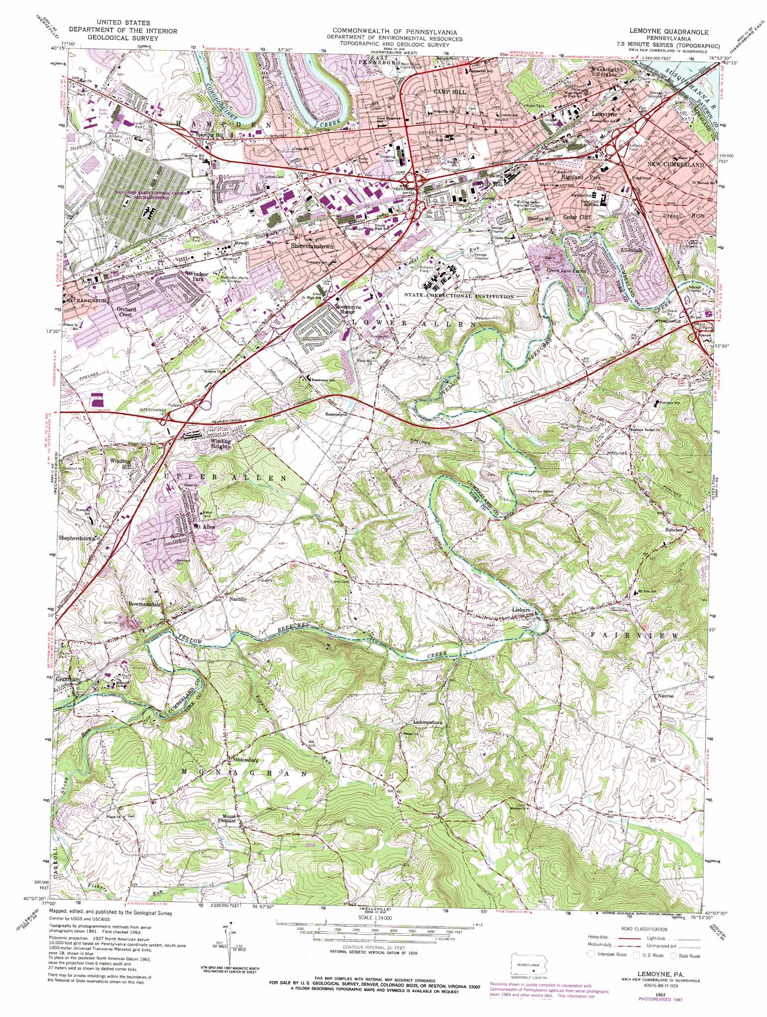
Lemoyne Topo Map Pennsylvania
To zoom in, hover over the map of Lemoyne
USGS Topo Quad 40076b8 - 1:24,000 scale
| Topo Map Name: | Lemoyne |
| USGS Topo Quad ID: | 40076b8 |
| Print Size: | ca. 21 1/4" wide x 27" high |
| Southeast Coordinates: | 40.125° N latitude / 76.875° W longitude |
| Map Center Coordinates: | 40.1875° N latitude / 76.9375° W longitude |
| U.S. State: | PA |
| Filename: | o40076b8.jpg |
| Download Map JPG Image: | Lemoyne topo map 1:24,000 scale |
| Map Type: | Topographic |
| Topo Series: | 7.5´ |
| Map Scale: | 1:24,000 |
| Source of Map Images: | United States Geological Survey (USGS) |
| Alternate Map Versions: |
Lemoyne PA 1963, updated 1965 Download PDF Buy paper map Lemoyne PA 1963, updated 1971 Download PDF Buy paper map Lemoyne PA 1963, updated 1972 Download PDF Buy paper map Lemoyne PA 1963, updated 1973 Download PDF Buy paper map Lemoyne PA 1963, updated 1987 Download PDF Buy paper map Lemoyne PA 1999, updated 2001 Download PDF Buy paper map Lemoyne PA 2010 Download PDF Buy paper map Lemoyne PA 2013 Download PDF Buy paper map Lemoyne PA 2016 Download PDF Buy paper map |
1:24,000 Topo Quads surrounding Lemoyne
Newport |
Duncannon |
Halifax |
Enders |
Grantville |
Shermans Dale |
Wertzville |
Harrisburg West |
Harrisburg East |
Hershey |
Carlisle |
Mechanicsburg |
Lemoyne |
Steelton |
Middletown |
Mount Holly Springs |
Dillsburg |
Wellsville |
Dover |
York Haven |
Biglerville |
Hampton |
Abbottstown |
West York |
York |
> Back to 40076a1 at 1:100,000 scale
> Back to 40076a1 at 1:250,000 scale
> Back to U.S. Topo Maps home
Lemoyne topo map: Gazetteer
Lemoyne: Airports
Vogelsong Airport elevation 207m 679′Lemoyne: Dams
Mill Dam elevation 96m 314′Upper Mill Dam elevation 99m 324′
Lemoyne: Parks
Lower Allen Community Park elevation 128m 419′Mount Allen Park elevation 164m 538′
Siebert Park elevation 144m 472′
Spring Run Park elevation 160m 524′
Starry Fields elevation 126m 413′
Willow Park elevation 127m 416′
Lemoyne: Populated Places
Allendale elevation 114m 374′Allenview elevation 183m 600′
Andersontown elevation 133m 436′
Bowmansdale elevation 124m 406′
Bunches elevation 213m 698′
Camp Hill elevation 135m 442′
Cedar Cliff elevation 115m 377′
Cedar Point elevation 145m 475′
Drexel Hills elevation 133m 436′
Eberlys Mill elevation 110m 360′
Fair Acres elevation 181m 593′
Flintlock Ridge elevation 172m 564′
Fort Couch elevation 159m 521′
Grantham elevation 136m 446′
Green Lane Farms elevation 117m 383′
Highland Park elevation 119m 390′
Holliday elevation 154m 505′
Howell elevation 128m 419′
Kimberly Meadows elevation 172m 564′
Lemoyne elevation 119m 390′
Limekiln Acres elevation 135m 442′
Lisburn elevation 123m 403′
Lower Allen elevation 117m 383′
Meadowbrook Mobile Home Park elevation 165m 541′
Memphord Estates elevation 159m 521′
Mount Allen elevation 182m 597′
Mount Allen Estates elevation 167m 547′
Mount Pleasant elevation 223m 731′
Nantilly elevation 130m 426′
Nauvoo elevation 156m 511′
Nauvoo Estates elevation 169m 554′
New Cumberland elevation 119m 390′
Oakwood Park elevation 141m 462′
Orchard Crest elevation 137m 449′
Orchard Terrace elevation 171m 561′
Peace Church elevation 133m 436′
Raven Hill elevation 125m 410′
Reservoir Hill elevation 179m 587′
Rossmoyne elevation 132m 433′
Rossmoyne Manor elevation 124m 406′
Shepherdstown elevation 192m 629′
Shiremanstown elevation 128m 419′
Siddonsburg elevation 187m 613′
Sporting Hill elevation 135m 442′
Spring Run Acres elevation 169m 554′
Spring Run Manor elevation 165m 541′
Timber Ridge elevation 165m 541′
Waseka Acres elevation 146m 479′
Washington Heights elevation 125m 410′
White Hill elevation 117m 383′
Winding Heights elevation 169m 554′
Winding Hill elevation 176m 577′
Windsor Park elevation 134m 439′
Lemoyne: Post Offices
Camp Hill Post Office (historical) elevation 131m 429′Lemoyne: Reservoirs
Camp Hill Borough Pool elevation 141m 462′Lemoyne: Springs
Eichelberger Spring elevation 115m 377′Spring Lake Spring elevation 114m 374′
Lemoyne: Streams
Cedar Point Run elevation 109m 357′Cedar Run elevation 94m 308′
Fishers Run elevation 146m 479′
Green Run elevation 112m 367′
Iron Stone Run elevation 102m 334′
Lime Kiln Run elevation 93m 305′
Line Run elevation 93m 305′
Millers Run elevation 111m 364′
Pippins Run elevation 118m 387′
Stony Run elevation 122m 400′
Trout Run elevation 127m 416′
Lemoyne digital topo map on disk
Buy this Lemoyne topo map showing relief, roads, GPS coordinates and other geographical features, as a high-resolution digital map file on DVD:
Atlantic Coast (NY, NJ, PA, DE, MD, VA, NC)
Buy digital topo maps: Atlantic Coast (NY, NJ, PA, DE, MD, VA, NC)
 map DVD")