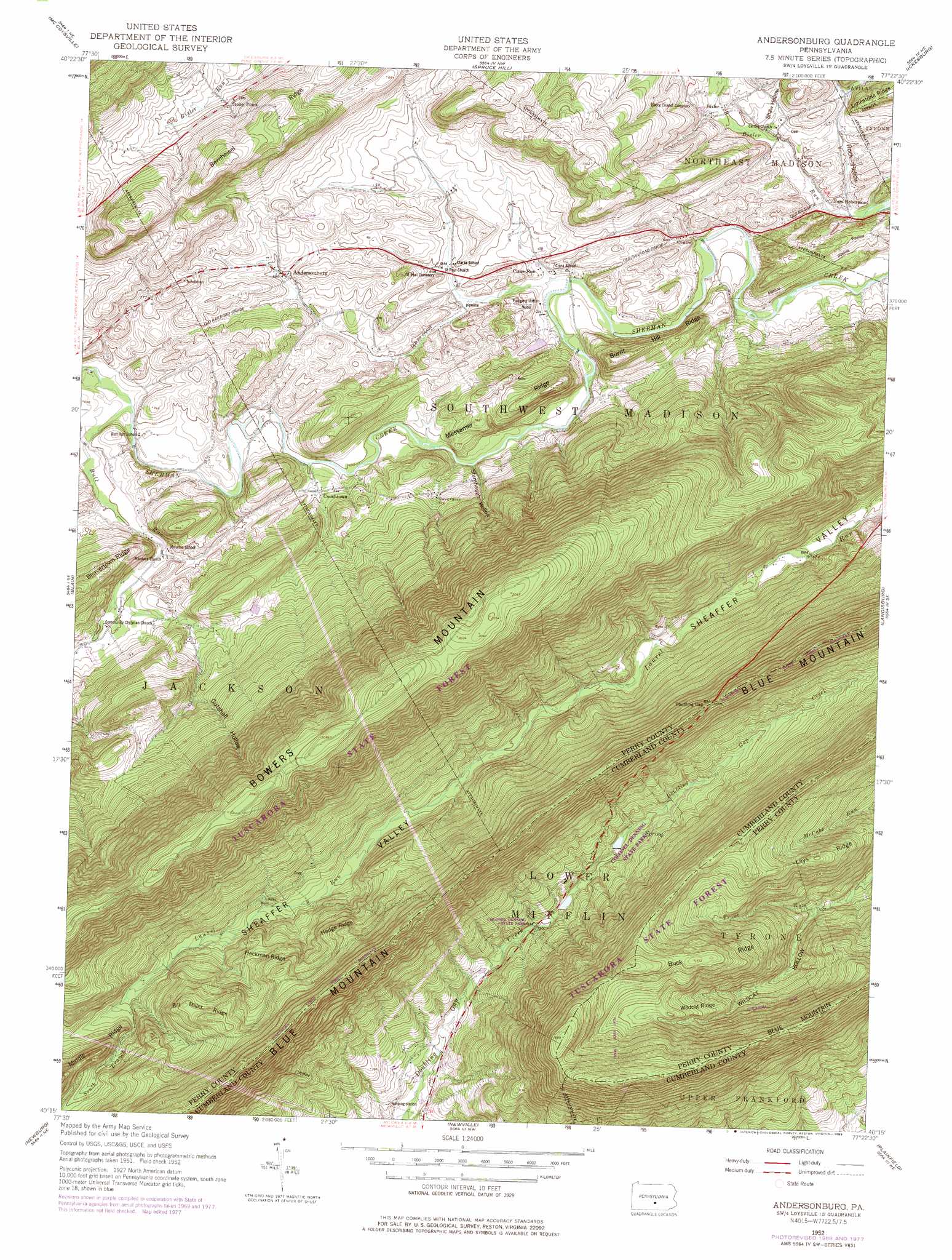
Andersonburg Topo Map Pennsylvania
To zoom in, hover over the map of Andersonburg
USGS Topo Quad 40077c4 - 1:24,000 scale
| Topo Map Name: | Andersonburg |
| USGS Topo Quad ID: | 40077c4 |
| Print Size: | ca. 21 1/4" wide x 27" high |
| Southeast Coordinates: | 40.25° N latitude / 77.375° W longitude |
| Map Center Coordinates: | 40.3125° N latitude / 77.4375° W longitude |
| U.S. State: | PA |
| Filename: | o40077c4.jpg |
| Download Map JPG Image: | Andersonburg topo map 1:24,000 scale |
| Map Type: | Topographic |
| Topo Series: | 7.5´ |
| Map Scale: | 1:24,000 |
| Source of Map Images: | United States Geological Survey (USGS) |
| Alternate Map Versions: |
Andersonburg PA 1952, updated 1958 Download PDF Buy paper map Andersonburg PA 1952, updated 1971 Download PDF Buy paper map Andersonburg PA 1952, updated 1978 Download PDF Buy paper map Andersonburg PA 1952, updated 1983 Download PDF Buy paper map Andersonburg PA 2010 Download PDF Buy paper map Andersonburg PA 2013 Download PDF Buy paper map Andersonburg PA 2016 Download PDF Buy paper map |
1:24,000 Topo Quads surrounding Andersonburg
Belleville |
Lewistown |
Mifflintown |
Mexico |
Millerstown |
Mcveytown |
Mccoysville |
Spruce Hill |
Ickesburg |
Newport |
Blairs Mills |
Blain |
Andersonburg |
Landisburg |
Shermans Dale |
Doylesburg |
Newburg |
Newville |
Plainfield |
Carlisle |
Roxbury |
Shippensburg |
Walnut Bottom |
Dickinson |
Mount Holly Springs |
> Back to 40077a1 at 1:100,000 scale
> Back to 40076a1 at 1:250,000 scale
> Back to U.S. Topo Maps home
Andersonburg topo map: Gazetteer
Andersonburg: Cliffs
Chimney Rocks elevation 523m 1715′Andersonburg: Dams
Lake Kimberly Dam elevation 194m 636′Andersonburg: Gaps
Doubling Gap elevation 451m 1479′Andersonburg: Parks
Colonel Denning State Park elevation 345m 1131′Andersonburg: Populated Places
Andersonburg elevation 211m 692′Bixler elevation 186m 610′
Centre elevation 189m 620′
Cisna Run elevation 195m 639′
Couchtown elevation 210m 688′
Doubling Gap elevation 253m 830′
Fort Robertson elevation 177m 580′
Stony Point elevation 257m 843′
Sundy Place elevation 323m 1059′
Andersonburg: Post Offices
Doubling Gap Post Office (historical) elevation 253m 830′Andersonburg: Ridges
Bernheisel Ridge elevation 341m 1118′Bill Miller Ridge elevation 460m 1509′
Buck Ridge elevation 529m 1735′
Burnt Hill Ridge elevation 289m 948′
Heckman Ridge elevation 441m 1446′
Hedge Ridge elevation 433m 1420′
Lays Ridge elevation 455m 1492′
Messamer Ridge elevation 265m 869′
Wildcat Ridge elevation 471m 1545′
Andersonburg: Streams
Bull Run elevation 203m 666′Cisna Run elevation 185m 606′
South Branch Laurel Run elevation 333m 1092′
Andersonburg: Summits
Bowers Mountain elevation 640m 2099′Flat Rock elevation 578m 1896′
Andersonburg: Trails
Bill Miller Trail elevation 449m 1473′Cider Path elevation 354m 1161′
Flat Rock Trail elevation 504m 1653′
Lightner Trail elevation 480m 1574′
Old Blain Trail elevation 451m 1479′
Woodburn Trail elevation 548m 1797′
Andersonburg: Valleys
Gutshall Hollow elevation 295m 967′Rock Hollow elevation 172m 564′
Shaw Hollow elevation 180m 590′
Stamhaugh Hollow elevation 192m 629′
Wildcat Hollow elevation 312m 1023′
Andersonburg digital topo map on disk
Buy this Andersonburg topo map showing relief, roads, GPS coordinates and other geographical features, as a high-resolution digital map file on DVD:
Atlantic Coast (NY, NJ, PA, DE, MD, VA, NC)
Buy digital topo maps: Atlantic Coast (NY, NJ, PA, DE, MD, VA, NC)
 map DVD")