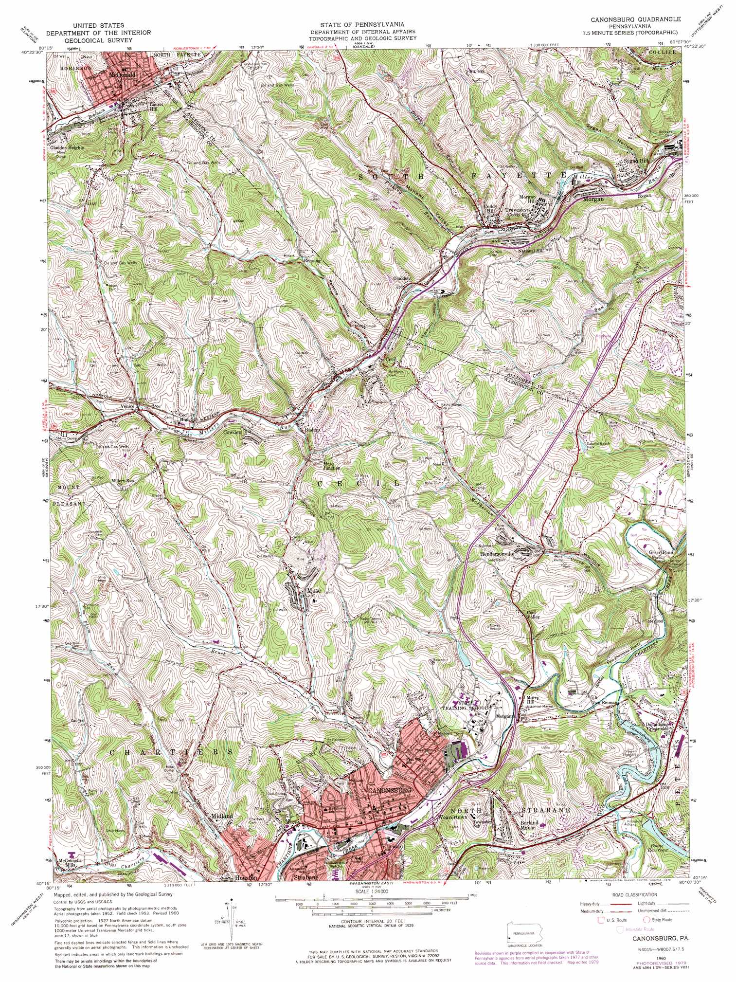
Canonsburg Topo Map Pennsylvania
To zoom in, hover over the map of Canonsburg
USGS Topo Quad 40080c2 - 1:24,000 scale
| Topo Map Name: | Canonsburg |
| USGS Topo Quad ID: | 40080c2 |
| Print Size: | ca. 21 1/4" wide x 27" high |
| Southeast Coordinates: | 40.25° N latitude / 80.125° W longitude |
| Map Center Coordinates: | 40.3125° N latitude / 80.1875° W longitude |
| U.S. State: | PA |
| Filename: | o40080c2.jpg |
| Download Map JPG Image: | Canonsburg topo map 1:24,000 scale |
| Map Type: | Topographic |
| Topo Series: | 7.5´ |
| Map Scale: | 1:24,000 |
| Source of Map Images: | United States Geological Survey (USGS) |
| Alternate Map Versions: |
Canonsburg PA 1953, updated 1955 Download PDF Buy paper map Canonsburg PA 1960, updated 1961 Download PDF Buy paper map Canonsburg PA 1960, updated 1961 Download PDF Buy paper map Canonsburg PA 1960, updated 1971 Download PDF Buy paper map Canonsburg PA 1960, updated 1979 Download PDF Buy paper map Canonsburg PA 1960, updated 1979 Download PDF Buy paper map Canonsburg PA 2010 Download PDF Buy paper map Canonsburg PA 2013 Download PDF Buy paper map Canonsburg PA 2016 Download PDF Buy paper map |
1:24,000 Topo Quads surrounding Canonsburg
Hookstown |
Aliquippa |
Ambridge |
Emsworth |
Glenshaw |
Burgettstown |
Clinton |
Oakdale |
Pittsburgh West |
Pittsburgh East |
Avella |
Midway |
Canonsburg |
Bridgeville |
Glassport |
West Middletown |
Washington West |
Washington East |
Hackett |
Monongahela |
Claysville |
Prosperity |
Amity |
Ellsworth |
California |
> Back to 40080a1 at 1:100,000 scale
> Back to 40080a1 at 1:250,000 scale
> Back to U.S. Topo Maps home
Canonsburg topo map: Gazetteer
Canonsburg: Airports
Campbell Airport elevation 356m 1167′Canonsburg: Dams
Alcoa Dam elevation 274m 898′Morganza Dam elevation 287m 941′
Speers Run Dam elevation 293m 961′
Canonsburg: Lakes
Van Emmans Ponds elevation 270m 885′Canonsburg: Parks
Canonsburg Town Park elevation 293m 961′Canonsburg: Populated Places
Bishop elevation 328m 1076′Borland Manor elevation 343m 1125′
Canonsburg elevation 334m 1095′
Cecil elevation 365m 1197′
Cool Valley elevation 305m 1000′
Cowden elevation 333m 1092′
Cuddy Hill elevation 285m 935′
Donaldsons Crossroads elevation 300m 984′
Gladden elevation 290m 951′
Gladden Heights elevation 321m 1053′
Hendersonville elevation 302m 990′
Laurel Hill elevation 336m 1102′
McConnells Mills elevation 296m 971′
McDonald elevation 303m 994′
McNary elevation 331m 1085′
Midland elevation 303m 994′
Morgan elevation 263m 862′
Morgan Hill elevation 296m 971′
Morganza elevation 296m 971′
Murry Hill elevation 297m 974′
Muse elevation 321m 1053′
Muse Junction elevation 330m 1082′
National Hill elevation 291m 954′
Reissing elevation 303m 994′
Strabane elevation 327m 1072′
Sygan elevation 264m 866′
Sygan Hill elevation 295m 967′
Treveskyn elevation 269m 882′
Van Emman elevation 280m 918′
Venice elevation 347m 1138′
Weavertown elevation 308m 1010′
Canonsburg: Post Offices
Canonsburg Post Office elevation 290m 951′Cecil Post Office elevation 293m 961′
Cuddy Post Office elevation 269m 882′
Gradatim Post Office (historical) elevation 290m 951′
McDonald Post Office elevation 298m 977′
McMurray Post Office elevation 298m 977′
Muse Post Office elevation 323m 1059′
Strabane Post Office elevation 294m 964′
Canonsburg: Reservoirs
Boone Reservoir elevation 293m 961′Canonsburg Lake elevation 274m 898′
Morganza Reservoir elevation 291m 954′
Canonsburg: Streams
Brush Run elevation 281m 921′Dolphin Run elevation 268m 879′
Fishing Run elevation 270m 885′
Little Chartiers Creek elevation 275m 902′
McPherson Creek elevation 267m 875′
Robb Run elevation 296m 971′
Canonsburg: Valleys
Mohawk Valley elevation 275m 902′Mosquito Hollow elevation 280m 918′
Reissing Hollow elevation 345m 1131′
Sygan Hollow elevation 260m 853′
Canonsburg digital topo map on disk
Buy this Canonsburg topo map showing relief, roads, GPS coordinates and other geographical features, as a high-resolution digital map file on DVD:
 map DVD")