Midland Topo Map Pennsylvania
To zoom in, hover over the map of Midland
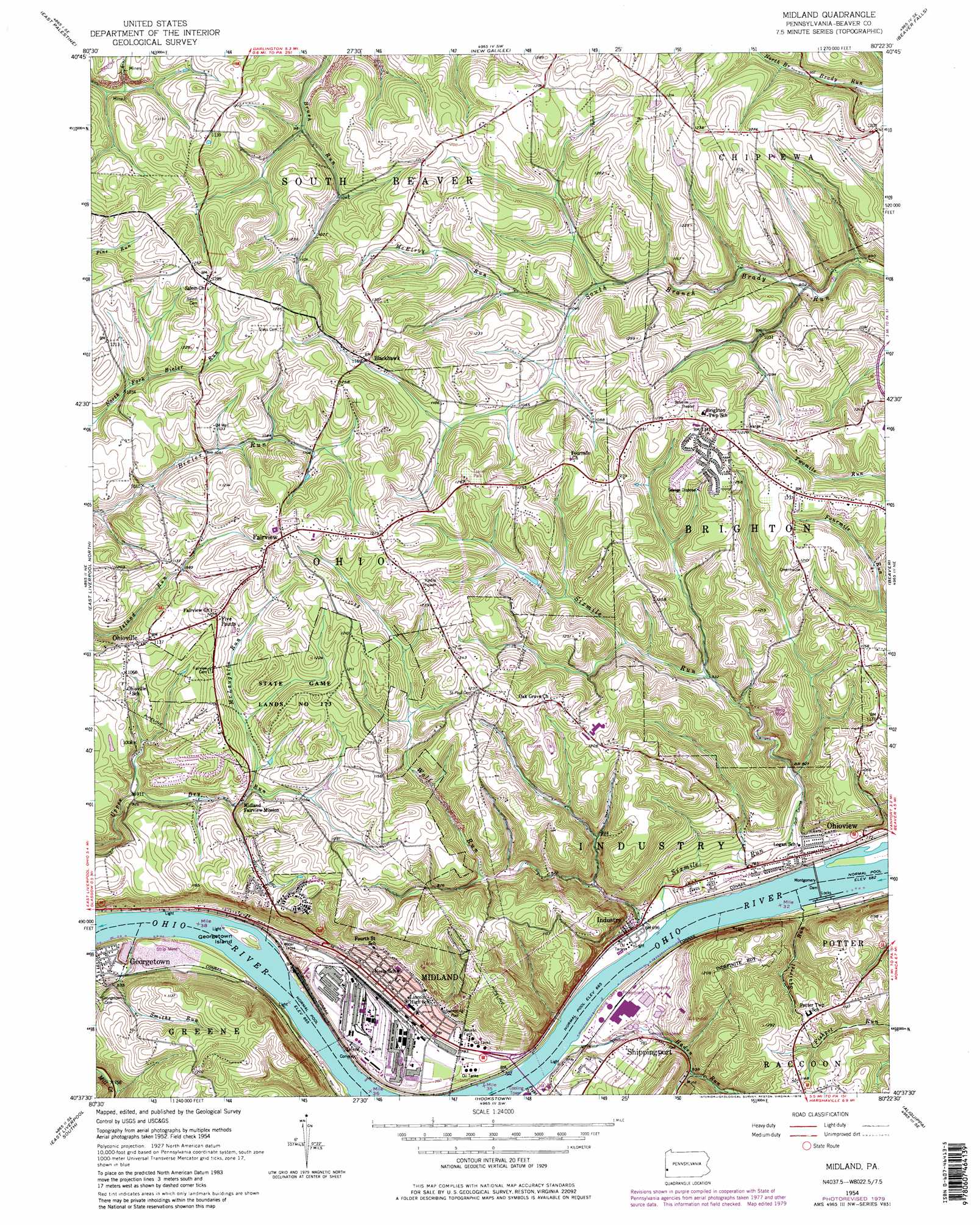
USGS Topo Quad 40080f4 - 1:24,000 scale
| Topo Map Name: | Midland |
| USGS Topo Quad ID: | 40080f4 |
| Print Size: | ca. 21 1/4" wide x 27" high |
| Southeast Coordinates: | 40.625° N latitude / 80.375° W longitude |
| Map Center Coordinates: | 40.6875° N latitude / 80.4375° W longitude |
| U.S. State: | PA |
| Filename: | o40080f4.jpg |
| Download Map JPG Image: | Midland topo map 1:24,000 scale |
| Map Type: | Topographic |
| Topo Series: | 7.5´ |
| Map Scale: | 1:24,000 |
| Source of Map Images: | United States Geological Survey (USGS) |
| Alternate Map Versions: |
Midland PA 1954, updated 1955 Download PDF Buy paper map Midland PA 1954, updated 1968 Download PDF Buy paper map Midland PA 1954, updated 1969 Download PDF Buy paper map Midland PA 1954, updated 1979 Download PDF Buy paper map Midland PA 1954, updated 1979 Download PDF Buy paper map Midland PA 2010 Download PDF Buy paper map Midland PA 2013 Download PDF Buy paper map Midland PA 2016 Download PDF Buy paper map |
1:24,000 Topo Quads surrounding Midland
Columbiana |
New Middletown |
Bessemer |
New Castle South |
Portersville |
Elkton |
East Palestine |
New Galilee |
Beaver Falls |
Zelienople |
West Point |
East Liverpool North |
Midland |
Beaver |
Baden |
Wellsville |
East Liverpool South |
Hookstown |
Aliquippa |
Ambridge |
Knoxville |
Weirton |
Burgettstown |
Clinton |
Oakdale |
> Back to 40080e1 at 1:100,000 scale
> Back to 40080a1 at 1:250,000 scale
> Back to U.S. Topo Maps home
Midland topo map: Gazetteer
Midland: Airports
Sainovich Airport elevation 348m 1141′Midland: Dams
Montgomery Dam elevation 208m 682′Montgomery Locks and Dam elevation 208m 682′
Midland: Islands
Georgetown Island elevation 206m 675′Montgomery Island (historical) elevation 210m 688′
Midland: Parks
State Game Lands Number 173 elevation 367m 1204′Midland: Populated Places
Blackhawk elevation 352m 1154′Dawson elevation 392m 1286′
Esther (historical) elevation 397m 1302′
Fairview elevation 387m 1269′
Five Points elevation 371m 1217′
Georgetown elevation 230m 754′
Industry elevation 213m 698′
Midland elevation 239m 784′
Ohioview elevation 246m 807′
Ohioville elevation 340m 1115′
Shippingport elevation 238m 780′
Midland: Post Offices
Blackhawk Post Office (historical) elevation 354m 1161′Midland: Streams
Haden Run elevation 204m 669′McElroy Run elevation 316m 1036′
McLaughlin Run elevation 298m 977′
Peggs Run elevation 203m 666′
Sixmile Run elevation 203m 666′
Smiths Run elevation 206m 675′
Squirrel Run elevation 206m 675′
Wolf Run elevation 203m 666′
Midland digital topo map on disk
Buy this Midland topo map showing relief, roads, GPS coordinates and other geographical features, as a high-resolution digital map file on DVD:
 map DVD")