Malvern Topo Map Ohio
To zoom in, hover over the map of Malvern
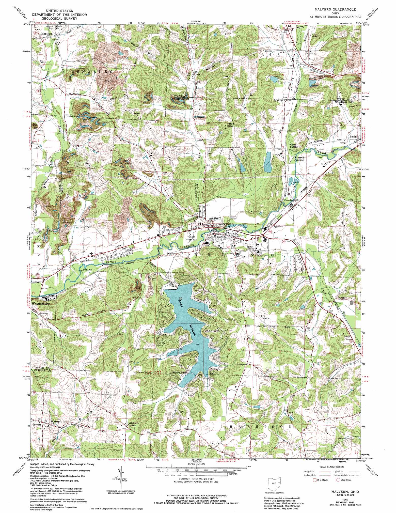
USGS Topo Quad 40081f2 - 1:24,000 scale
| Topo Map Name: | Malvern |
| USGS Topo Quad ID: | 40081f2 |
| Print Size: | ca. 21 1/4" wide x 27" high |
| Southeast Coordinates: | 40.625° N latitude / 81.125° W longitude |
| Map Center Coordinates: | 40.6875° N latitude / 81.1875° W longitude |
| U.S. State: | OH |
| Filename: | o40081f2.jpg |
| Download Map JPG Image: | Malvern topo map 1:24,000 scale |
| Map Type: | Topographic |
| Topo Series: | 7.5´ |
| Map Scale: | 1:24,000 |
| Source of Map Images: | United States Geological Survey (USGS) |
| Alternate Map Versions: |
Malvern OH 1960, updated 1961 Download PDF Buy paper map Malvern OH 1960, updated 1972 Download PDF Buy paper map Malvern OH 1960, updated 1985 Download PDF Buy paper map Malvern OH 1960, updated 1992 Download PDF Buy paper map Malvern OH 1994, updated 1998 Download PDF Buy paper map Malvern OH 2010 Download PDF Buy paper map Malvern OH 2013 Download PDF Buy paper map Malvern OH 2016 Download PDF Buy paper map |
1:24,000 Topo Quads surrounding Malvern
North Canton |
Hartville |
Limaville |
Alliance |
Damascus |
Canton West |
Canton East |
Robertsville |
Homeworth |
Hanoverton |
Bolivar |
Waynesburg |
Malvern |
Minerva |
Kensington |
Dover |
Mineral City |
Dellroy |
Carrollton |
Bergholz |
New Philadelphia |
Uhrichsville |
Bowerston |
Scio |
Amsterdam |
> Back to 40081e1 at 1:100,000 scale
> Back to 40080a1 at 1:250,000 scale
> Back to U.S. Topo Maps home
Malvern topo map: Gazetteer
Malvern: Airports
Foltz Heliport elevation 314m 1030′Minerva Airport elevation 331m 1085′
Schneider-Mohawk Airport elevation 373m 1223′
Malvern: Dams
Great Trails Girl Scouts Pond Dam elevation 317m 1040′Hill Pond Dam elevation 320m 1049′
Lake Mohawk Dam elevation 311m 1020′
Pride Valley Beach Club Dam elevation 325m 1066′
Squaw Valley Lake Dam elevation 324m 1062′
Malvern: Parks
Village Park elevation 303m 994′Malvern: Populated Places
Bon Air Estates elevation 337m 1105′Fritchleys Corners elevation 372m 1220′
Lake Mohawk elevation 369m 1210′
Leyda elevation 315m 1033′
Malvern elevation 303m 994′
Mapleton elevation 320m 1049′
Minerva Junction elevation 309m 1013′
Morges elevation 355m 1164′
Oneida elevation 307m 1007′
Sandy Hills Estates elevation 317m 1040′
Skyland Pines Mobile Home Park elevation 322m 1056′
Woodale Village Mobile Home Park elevation 330m 1082′
Malvern: Post Offices
Malvern Post Office elevation 302m 990′Mapleton Post Office (historical) elevation 317m 1040′
Oneida Post Office (historical) elevation 308m 1010′
Malvern: Reservoirs
Great Trails Girl Scouts Pond elevation 317m 1040′Hill Pond elevation 320m 1049′
Lake Mohawk elevation 311m 1020′
Pride Valley Beach Club Reservoir elevation 325m 1066′
Squaw Valley Lake elevation 324m 1062′
Malvern: Streams
Armstrong Run elevation 298m 977′Black Run elevation 310m 1017′
Hugle Run elevation 308m 1010′
Middle Run elevation 298m 977′
Pipe Run elevation 301m 987′
Malvern: Valleys
Turkey Hollow elevation 301m 987′Malvern digital topo map on disk
Buy this Malvern topo map showing relief, roads, GPS coordinates and other geographical features, as a high-resolution digital map file on DVD:
 map DVD")