Cosmos Topo Map Indiana
To zoom in, hover over the map of Cosmos
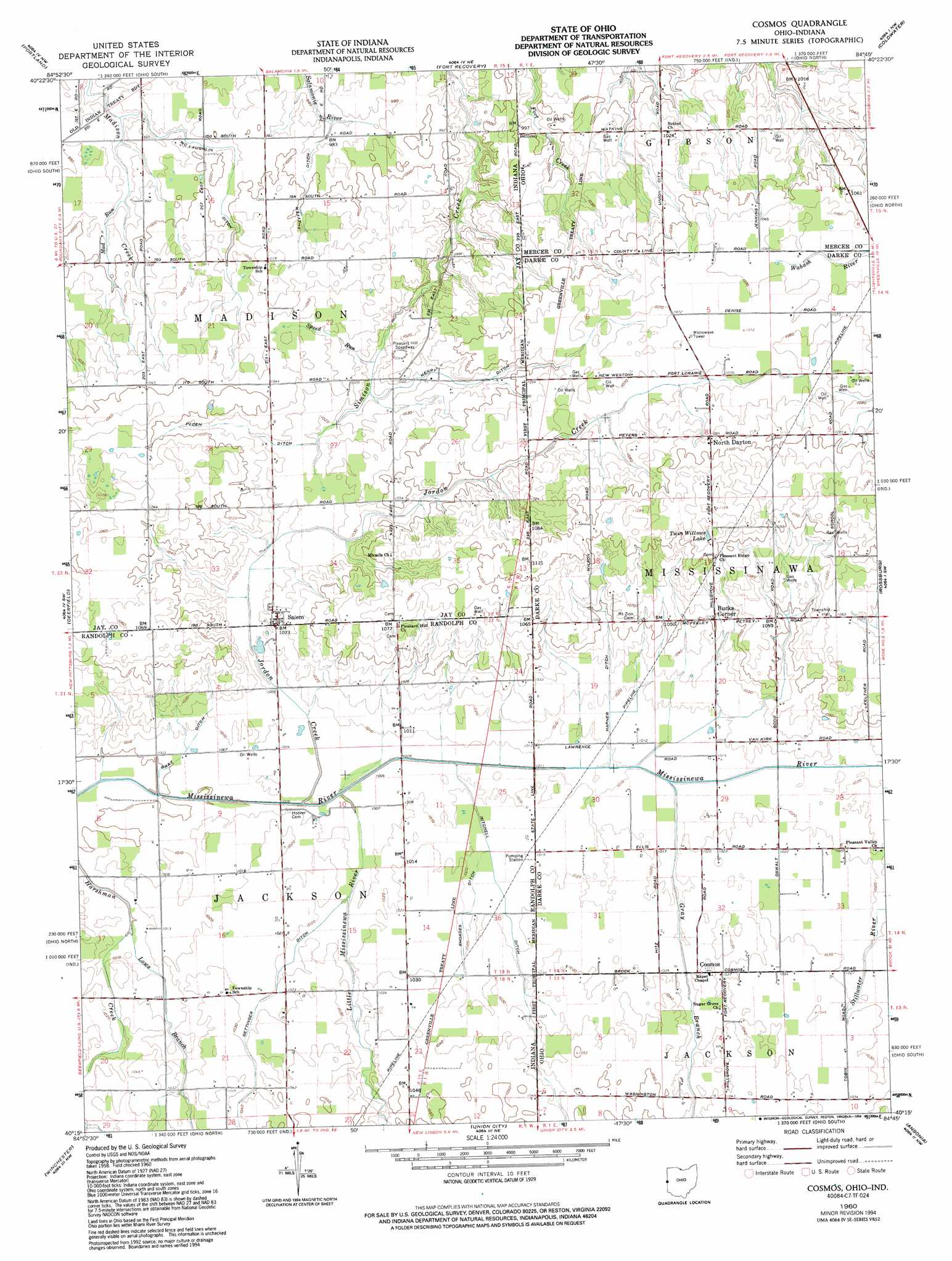
USGS Topo Quad 40084c7 - 1:24,000 scale
| Topo Map Name: | Cosmos |
| USGS Topo Quad ID: | 40084c7 |
| Print Size: | ca. 21 1/4" wide x 27" high |
| Southeast Coordinates: | 40.25° N latitude / 84.75° W longitude |
| Map Center Coordinates: | 40.3125° N latitude / 84.8125° W longitude |
| U.S. States: | IN, OH |
| Filename: | o40084c7.jpg |
| Download Map JPG Image: | Cosmos topo map 1:24,000 scale |
| Map Type: | Topographic |
| Topo Series: | 7.5´ |
| Map Scale: | 1:24,000 |
| Source of Map Images: | United States Geological Survey (USGS) |
| Alternate Map Versions: |
Cosmos OH 1960, updated 1961 Download PDF Buy paper map Cosmos OH 1960, updated 1973 Download PDF Buy paper map Cosmos OH 1960, updated 1973 Download PDF Buy paper map Cosmos OH 1960, updated 1994 Download PDF Buy paper map Cosmos OH 2010 Download PDF Buy paper map Cosmos OH 2013 Download PDF Buy paper map Cosmos OH 2016 Download PDF Buy paper map |
1:24,000 Topo Quads surrounding Cosmos
Domestic |
Geneva |
New Corydon |
Erastus |
Celina |
Blaine |
Portland |
Fort Recovery |
Coldwater |
Montezuma |
Ridgeville |
Deerfield |
Cosmos |
Rossburg |
North Star |
Maxville |
Winchester |
Union City |
Ansonia |
Dawn |
Carlos |
Lynn |
Spartanburg |
Greenville West |
Greenville East |
> Back to 40084a1 at 1:100,000 scale
> Back to 40084a1 at 1:250,000 scale
> Back to U.S. Topo Maps home
Cosmos topo map: Gazetteer
Cosmos: Canals
Bray Ditch elevation 306m 1003′Gettinger Ditch elevation 311m 1020′
Henry Ditch elevation 315m 1033′
McLaughlin Ditch elevation 303m 994′
Mitchell Ditch elevation 311m 1020′
Peden Ditch elevation 315m 1033′
Rhoades Ditch elevation 310m 1017′
Sheffer Ditch elevation 303m 994′
Cosmos: Populated Places
Bucks Corner elevation 320m 1049′Cosmos elevation 313m 1026′
North Dayton elevation 332m 1089′
Salem elevation 314m 1030′
Cosmos: Post Offices
Cosmos Post Office (historical) elevation 314m 1030′Cosmos: Reservoirs
Twin Willows Lake elevation 338m 1108′Cosmos: Streams
Gray Branch elevation 308m 1010′Jordon Creek elevation 305m 1000′
Jordon Creek elevation 305m 1000′
Little Mississinewa River elevation 305m 1000′
Lows Branch elevation 305m 1000′
Mad Run elevation 298m 977′
Speed Run elevation 307m 1007′
Cosmos digital topo map on disk
Buy this Cosmos topo map showing relief, roads, GPS coordinates and other geographical features, as a high-resolution digital map file on DVD:
Northern Illinois, Northern Indiana & Southwestern Michigan
Buy digital topo maps: Northern Illinois, Northern Indiana & Southwestern Michigan