Saint Marys Topo Map Ohio
To zoom in, hover over the map of Saint Marys
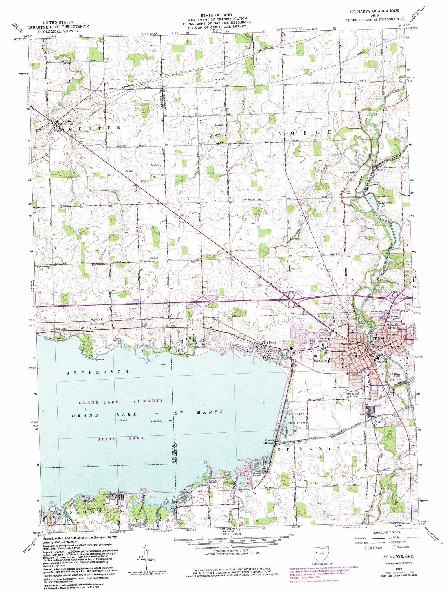
USGS Topo Quad 40084e4 - 1:24,000 scale
| Topo Map Name: | Saint Marys |
| USGS Topo Quad ID: | 40084e4 |
| Print Size: | ca. 21 1/4" wide x 27" high |
| Southeast Coordinates: | 40.5° N latitude / 84.375° W longitude |
| Map Center Coordinates: | 40.5625° N latitude / 84.4375° W longitude |
| U.S. State: | OH |
| Filename: | o40084e4.jpg |
| Download Map JPG Image: | Saint Marys topo map 1:24,000 scale |
| Map Type: | Topographic |
| Topo Series: | 7.5´ |
| Map Scale: | 1:24,000 |
| Source of Map Images: | United States Geological Survey (USGS) |
| Alternate Map Versions: |
St. Marys OH 1960, updated 1961 Download PDF Buy paper map St. Marys OH 1960, updated 1975 Download PDF Buy paper map St. Marys OH 1960, updated 1983 Download PDF Buy paper map Saint Marys OH 2010 Download PDF Buy paper map Saint Marys OH 2013 Download PDF Buy paper map Saint Marys OH 2016 Download PDF Buy paper map |
1:24,000 Topo Quads surrounding Saint Marys
Glenmore |
Van Wert |
Middle Point |
Delphos |
Elida |
Rockford |
Mendon |
Elgin |
Spencerville |
Cridersville |
Erastus |
Celina |
Saint Marys |
Moulton |
Wapakoneta |
Coldwater |
Montezuma |
New Bremen |
New Knoxville |
Botkins |
Rossburg |
North Star |
Osgood |
Fort Loramie |
Sidney |
> Back to 40084e1 at 1:100,000 scale
> Back to 40084a1 at 1:250,000 scale
> Back to U.S. Topo Maps home
Saint Marys topo map: Gazetteer
Saint Marys: Airports
Fortman Airport elevation 268m 879′Saint Marys: Dams
Forty Acre Pond Dam elevation 258m 846′Saint Marys: Parks
Armstrong Park elevation 271m 889′Geiger Park elevation 263m 862′
Grand Lake State Park elevation 263m 862′
Larkin Park elevation 261m 856′
Saint Marys: Populated Places
Breezewood elevation 265m 869′Bulkhead elevation 265m 869′
Club Island elevation 265m 869′
Doss Landing elevation 265m 869′
Duckfoot Landing elevation 266m 872′
Harmons Landing elevation 267m 875′
Hechts Landing elevation 265m 869′
Idlewild elevation 272m 892′
Lees Landing elevation 265m 869′
Neptune elevation 259m 849′
Northwood elevation 267m 875′
Saint Marys elevation 264m 866′
Sandy Beach elevation 272m 892′
South Shore Acres elevation 266m 872′
Southmoor Shores elevation 265m 869′
Villa Nova elevation 270m 885′
Saint Marys: Post Offices
Neptune Post Office (historical) elevation 259m 849′Saint Marys Post Office elevation 265m 869′
Saint Marys: Reservoirs
Forty Acre Pond elevation 258m 846′Grand Lake elevation 265m 869′
Saint Marys: Streams
Barnes Creek elevation 265m 869′Chickasaw Creek elevation 264m 866′
Fourmile Creek elevation 254m 833′
Kopp Creek elevation 259m 849′
Little Chickasaw Creek elevation 265m 869′
Saint Marys digital topo map on disk
Buy this Saint Marys topo map showing relief, roads, GPS coordinates and other geographical features, as a high-resolution digital map file on DVD:
Northern Illinois, Northern Indiana & Southwestern Michigan
Buy digital topo maps: Northern Illinois, Northern Indiana & Southwestern Michigan