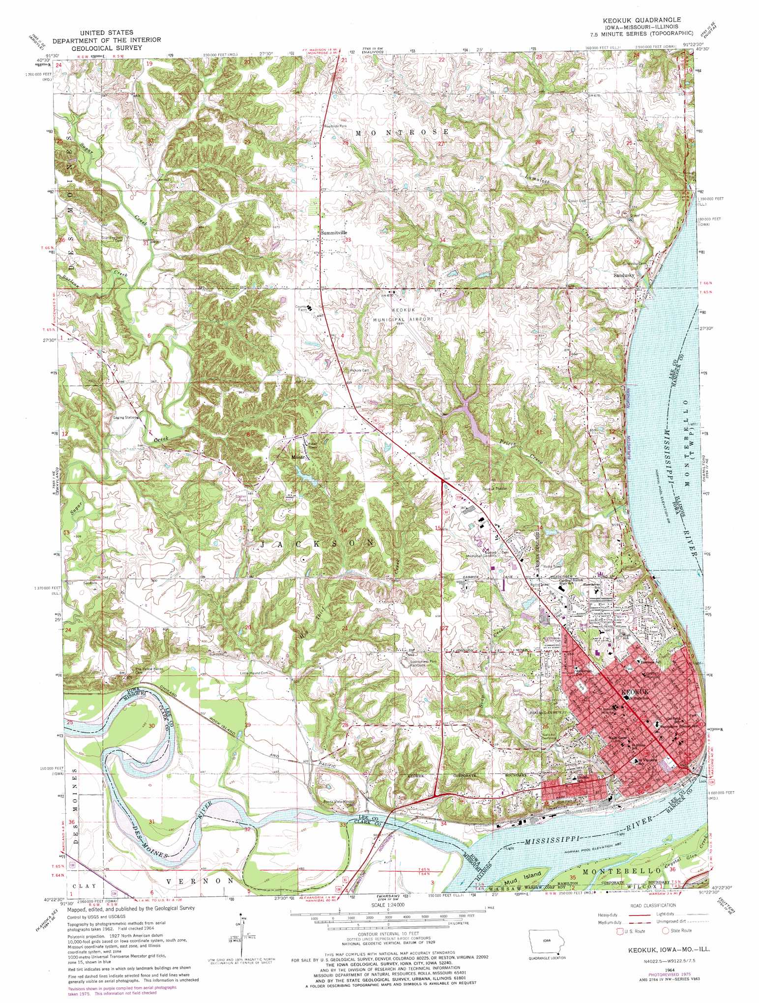
Keokuk Topo Map Iowa
To zoom in, hover over the map of Keokuk
USGS Topo Quad 40091d4 - 1:24,000 scale
| Topo Map Name: | Keokuk |
| USGS Topo Quad ID: | 40091d4 |
| Print Size: | ca. 21 1/4" wide x 27" high |
| Southeast Coordinates: | 40.375° N latitude / 91.375° W longitude |
| Map Center Coordinates: | 40.4375° N latitude / 91.4375° W longitude |
| U.S. States: | IA, IL, MO |
| Filename: | o40091d4.jpg |
| Download Map JPG Image: | Keokuk topo map 1:24,000 scale |
| Map Type: | Topographic |
| Topo Series: | 7.5´ |
| Map Scale: | 1:24,000 |
| Source of Map Images: | United States Geological Survey (USGS) |
| Alternate Map Versions: |
Keokuk IA 1964, updated 1965 Download PDF Buy paper map Keokuk IA 1964, updated 1975 Download PDF Buy paper map Keokuk IA 1964, updated 1977 Download PDF Buy paper map Keokuk IA 2012 Download PDF Buy paper map Keokuk IA 2013 Download PDF Buy paper map Keokuk IA 2015 Download PDF Buy paper map |
1:24,000 Topo Quads surrounding Keokuk
Farmington |
Donnellson |
West Point |
Fort Madison |
Dallas City |
Croton |
Argyle |
Nauvoo |
Niota |
Colusa |
Kahoka |
Wayland |
Keokuk |
Hamilton |
Carthage West |
Saint Patrick |
Kahoka Se |
Warsaw |
Sutter |
West Point |
Benjamin |
Canton |
Lima |
Tioga |
Loraine |
> Back to 40091a1 at 1:100,000 scale
> Back to 40090a1 at 1:250,000 scale
> Back to U.S. Topo Maps home
Keokuk topo map: Gazetteer
Keokuk: Airports
Bickel Stolport elevation 193m 633′Kah Heliport elevation 186m 610′
Keokuk Municipal Airport elevation 200m 656′
Keokuk: Dams
McDowell Lake Dam One elevation 174m 570′Keokuk: Islands
Mud Island elevation 151m 495′Keokuk: Parks
Bluff Park elevation 162m 531′Calvert Stadium elevation 194m 636′
Chatfield Park elevation 173m 567′
Chief Keokuk Memorial Historical Marker elevation 196m 643′
General Samuel Curtis Statue elevation 152m 498′
Joseph Patterson Historical Marker elevation 180m 590′
Joyce Park elevation 201m 659′
Kilbourne Park elevation 191m 626′
Kiser Park elevation 184m 603′
Rand Park elevation 191m 626′
Rees Park elevation 195m 639′
Riverview Park elevation 168m 551′
Samuel Freeman Miller State Historical Marker elevation 199m 652′
Tolmie Park elevation 201m 659′
Triangular Park elevation 187m 613′
Tumelty Park elevation 187m 613′
USS Maine Memorial Tablet Historical Marker elevation 196m 643′
Victory Park elevation 148m 485′
Keokuk: Populated Places
Buena Vista (historical) elevation 152m 498′Hocker Estates Mobile Home Park elevation 201m 659′
Keokuk elevation 174m 570′
Mooar elevation 204m 669′
Sandusky elevation 165m 541′
Sandusky Mobile Home Villa elevation 177m 580′
Skyview Mobile Home Park elevation 201m 659′
Summitville elevation 205m 672′
Keokuk: Post Offices
Keokuk Post Office elevation 171m 561′Mooar Post Office (historical) elevation 204m 669′
Sandusky Post Office (historical) elevation 165m 541′
Summitville Post Office (historical) elevation 205m 672′
Keokuk: Streams
Barlean Creek elevation 161m 528′Cedar Glen Creek elevation 150m 492′
Grape Creek elevation 172m 564′
Hog Theif Creek elevation 149m 488′
Lamalees Creek elevation 157m 515′
Prices Creek elevation 158m 518′
Soap Creek elevation 152m 498′
Keokuk digital topo map on disk
Buy this Keokuk topo map showing relief, roads, GPS coordinates and other geographical features, as a high-resolution digital map file on DVD: