Cozad Topo Map Nebraska
To zoom in, hover over the map of Cozad
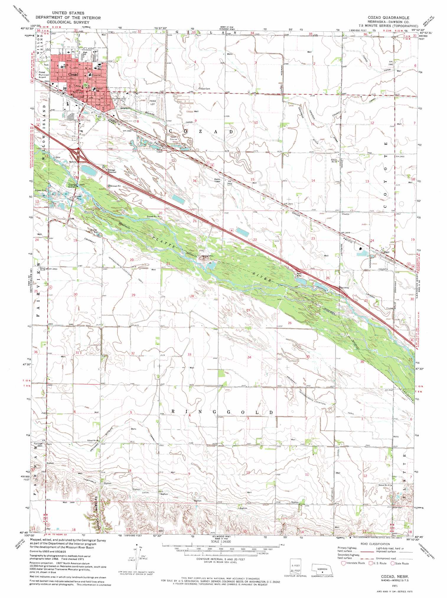
USGS Topo Quad 40099g8 - 1:24,000 scale
| Topo Map Name: | Cozad |
| USGS Topo Quad ID: | 40099g8 |
| Print Size: | ca. 21 1/4" wide x 27" high |
| Southeast Coordinates: | 40.75° N latitude / 99.875° W longitude |
| Map Center Coordinates: | 40.8125° N latitude / 99.9375° W longitude |
| U.S. State: | NE |
| Filename: | O40099g8.jpg |
| Download Map JPG Image: | Cozad topo map 1:24,000 scale |
| Map Type: | Topographic |
| Topo Series: | 7.5´ |
| Map Scale: | 1:24,000 |
| Source of Map Images: | United States Geological Survey (USGS) |
| Alternate Map Versions: |
Cozad NE 1971, updated 1973 Download PDF Buy paper map Cozad NE 2011 Download PDF Buy paper map Cozad NE 2014 Download PDF Buy paper map |
1:24,000 Topo Quads surrounding Cozad
Odencranze Table South |
Roten Valley South |
Oconto Sw |
Oconto Se |
Eddyville Sw |
Gothenburg |
Willow Island |
Cozad Nw |
Buffalo |
Lexington Nw |
Gothenburg Sw |
Gothenburg Se |
Cozad |
Lexington West |
Lexington East |
Farnam |
Eustis |
Elwood Nw |
Johnson Lake |
Bertrand Nw |
Eustis Sw |
Eustis Se |
Elwood Sw |
Elwood |
Bertrand |
> Back to 40099e1 at 1:100,000 scale
> Back to 40098a1 at 1:250,000 scale
> Back to U.S. Topo Maps home
Cozad topo map: Gazetteer
Cozad: Canals
Darr Lateral elevation 752m 2467′Dawson County Drainage Ditch elevation 751m 2463′
Cozad: Crossings
Interchange 222 elevation 762m 2500′Cozad: Dams
Dawson County Diversion Dam elevation 758m 2486′Velte Dam elevation 774m 2539′
Wichelt Dam elevation 779m 2555′
Cozad: Parks
Bellamy Ballpark elevation 758m 2486′Centennial Park elevation 760m 2493′
Central Platte Valley Historical Marker elevation 750m 2460′
Cozad City Park elevation 759m 2490′
Cozad State Wildlife Management Area elevation 756m 2480′
Darr Strip State Wildlife Management Area elevation 747m 2450′
Frenchy Park elevation 758m 2486′
Muny Park elevation 760m 2493′
Sportsman Field elevation 758m 2486′
The 100th Meridian Historical Marker elevation 759m 2490′
Cozad: Populated Places
Cozad elevation 759m 2490′Darr elevation 747m 2450′
Horizon Mobile Home Park elevation 758m 2486′
Cozad: Post Offices
Cozad Post Office elevation 759m 2490′Darr Post Office (historical) elevation 747m 2450′
Cozad: Reservoirs
Cozad Lake elevation 756m 2480′Dawson County Diversion Reservoir elevation 758m 2486′
Velte Reservoir elevation 774m 2539′
Wichelt Reservoir elevation 779m 2555′
Cozad: Valleys
Gallagher Canyon elevation 774m 2539′Cozad digital topo map on disk
Buy this Cozad topo map showing relief, roads, GPS coordinates and other geographical features, as a high-resolution digital map file on DVD: