Kinikinik Topo Map Colorado
To zoom in, hover over the map of Kinikinik
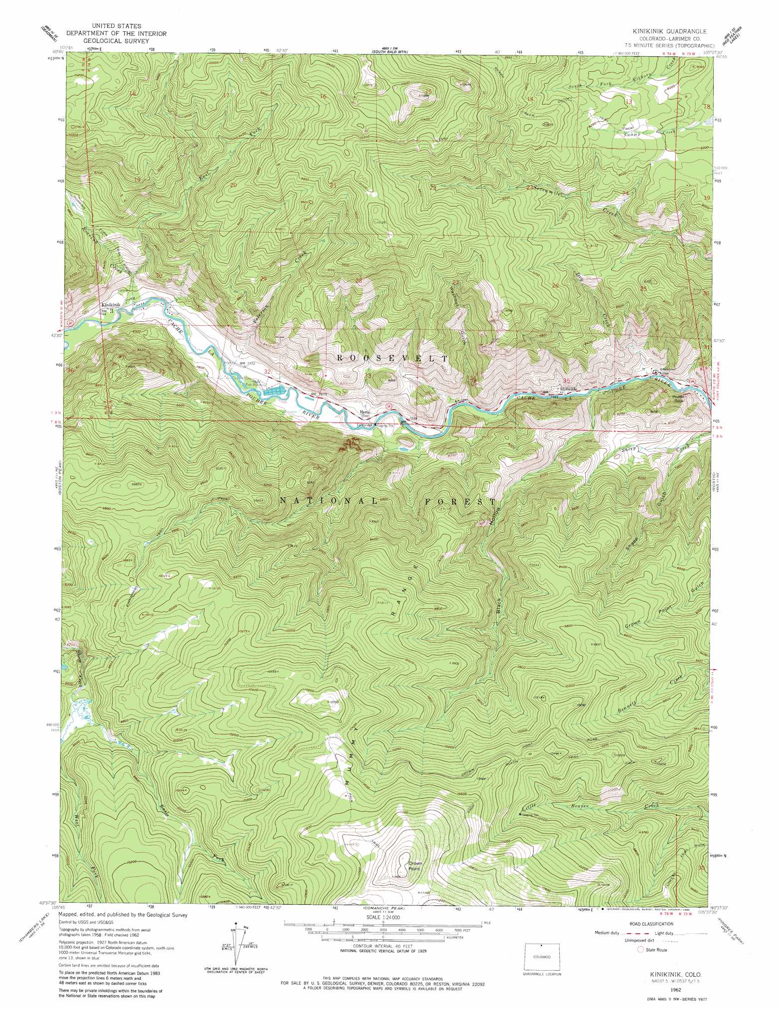
USGS Topo Quad 40105f6 - 1:24,000 scale
| Topo Map Name: | Kinikinik |
| USGS Topo Quad ID: | 40105f6 |
| Print Size: | ca. 21 1/4" wide x 27" high |
| Southeast Coordinates: | 40.625° N latitude / 105.625° W longitude |
| Map Center Coordinates: | 40.6875° N latitude / 105.6875° W longitude |
| U.S. State: | CO |
| Filename: | o40105f6.jpg |
| Download Map JPG Image: | Kinikinik topo map 1:24,000 scale |
| Map Type: | Topographic |
| Topo Series: | 7.5´ |
| Map Scale: | 1:24,000 |
| Source of Map Images: | United States Geological Survey (USGS) |
| Alternate Map Versions: |
Kinikinik CO 1962, updated 1964 Download PDF Buy paper map Kinikinik CO 1962, updated 1970 Download PDF Buy paper map Kinikinik CO 1962, updated 1970 Download PDF Buy paper map Kinikinik CO 1962, updated 1980 Download PDF Buy paper map Kinikinik CO 2011 Download PDF Buy paper map Kinikinik CO 2013 Download PDF Buy paper map Kinikinik CO 2016 Download PDF Buy paper map |
| FStopo: | US Forest Service topo Kinikinik is available: Download FStopo PDF Download FStopo TIF |
1:24,000 Topo Quads surrounding Kinikinik
Crazy Mountain |
Sand Creek Pass |
Eaton Reservoir |
Diamond Peak |
Cherokee Park |
Glendevey |
Deadman |
South Bald Mountain |
Red Feather Lakes |
Haystack Gulch |
Rawah Lakes |
Boston Peak |
Kinikinik |
Rustic |
Big Narrows |
Clark Peak |
Chambers Lake |
Comanche Peak |
Pingree Park |
Crystal Mountain |
Mount Richthofen |
Fall River Pass |
Trail Ridge |
Estes Park |
Glen Haven |
> Back to 40105e1 at 1:100,000 scale
> Back to 40104a1 at 1:250,000 scale
> Back to U.S. Topo Maps home
Kinikinik topo map: Gazetteer
Kinikinik: Cliffs
Profile Rock elevation 2379m 7805′Kinikinik: Mines
Chaney-Sims Beryl Mine elevation 2383m 7818′Kinikinik: Populated Places
Idylwilde elevation 2296m 7532′Kinikinik elevation 2356m 7729′
Kinikinik: Streams
Dry Creek elevation 2258m 7408′East Fork Roaring Creek elevation 2779m 9117′
East Fork Sheep Creek elevation 2884m 9461′
Peterson Creek elevation 2338m 7670′
Roaring Creek elevation 2353m 7719′
Sheep Creek elevation 2513m 8244′
West Fork Sheep Creek elevation 2884m 9461′
Kinikinik: Summits
Crown Point elevation 3478m 11410′Kinikinik: Trails
Dadd Gulch Trail elevation 3206m 10518′Swamp Creek Cutoff Trail elevation 2828m 9278′
Kinikinik: Valleys
Black Hollow elevation 2271m 7450′Sheep Gulch elevation 2318m 7604′
Washout Gulch elevation 2303m 7555′
Kinikinik digital topo map on disk
Buy this Kinikinik topo map showing relief, roads, GPS coordinates and other geographical features, as a high-resolution digital map file on DVD: