Red Feather Lakes Topo Map Colorado
To zoom in, hover over the map of Red Feather Lakes
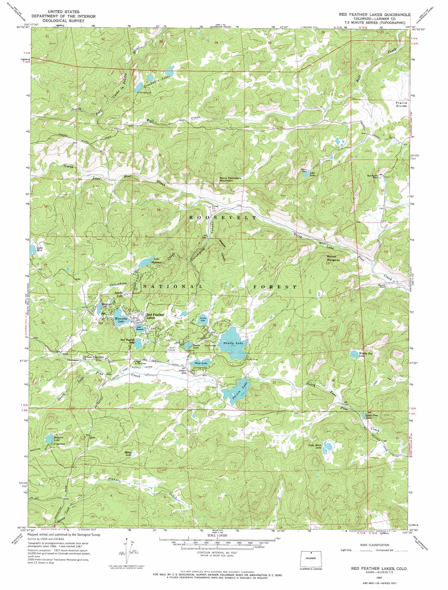
USGS Topo Quad 40105g5 - 1:24,000 scale
| Topo Map Name: | Red Feather Lakes |
| USGS Topo Quad ID: | 40105g5 |
| Print Size: | ca. 21 1/4" wide x 27" high |
| Southeast Coordinates: | 40.75° N latitude / 105.5° W longitude |
| Map Center Coordinates: | 40.8125° N latitude / 105.5625° W longitude |
| U.S. State: | CO |
| Filename: | o40105g5.jpg |
| Download Map JPG Image: | Red Feather Lakes topo map 1:24,000 scale |
| Map Type: | Topographic |
| Topo Series: | 7.5´ |
| Map Scale: | 1:24,000 |
| Source of Map Images: | United States Geological Survey (USGS) |
| Alternate Map Versions: |
Red Feather Lakes CO 1967, updated 1971 Download PDF Buy paper map Red Feather Lakes CO 1967, updated 1975 Download PDF Buy paper map Red Feather Lakes CO 2011 Download PDF Buy paper map Red Feather Lakes CO 2013 Download PDF Buy paper map Red Feather Lakes CO 2016 Download PDF Buy paper map |
| FStopo: | US Forest Service topo Red Feather Lakes is available: Download FStopo PDF Download FStopo TIF |
1:24,000 Topo Quads surrounding Red Feather Lakes
Downey Lakes |
Johnson Ranch |
Best Ranch |
Dale Creek |
Buford |
Sand Creek Pass |
Eaton Reservoir |
Diamond Peak |
Cherokee Park |
Virginia Dale |
Deadman |
South Bald Mountain |
Red Feather Lakes |
Haystack Gulch |
Livermore Mountain |
Boston Peak |
Kinikinik |
Rustic |
Big Narrows |
Poudre Park |
Chambers Lake |
Comanche Peak |
Pingree Park |
Crystal Mountain |
Buckhorn Mountain |
> Back to 40105e1 at 1:100,000 scale
> Back to 40104a1 at 1:250,000 scale
> Back to U.S. Topo Maps home
Red Feather Lakes topo map: Gazetteer
Red Feather Lakes: Canals
South Pine Supply Ditch elevation 2513m 8244′Red Feather Lakes: Dams
Bellaire Dam elevation 2645m 8677′Deer Lake Dam elevation 2492m 8175′
Dowdy Lake Dam elevation 2481m 8139′
Erie Lake Dam elevation 2619m 8592′
Fox Acres Dam elevation 2479m 8133′
Fox Acres Number 2 Dam elevation 2467m 8093′
Haviland Dam elevation 2473m 8113′
Lone Pine Dam elevation 2431m 7975′
Mitchell Number 1 Dam elevation 2547m 8356′
Mitchell Number 3 Dam elevation 2548m 8359′
Nakomis Lake Dam elevation 2514m 8248′
Ramona Dam elevation 2573m 8441′
Snake Lake Dam elevation 2512m 8241′
Twin Lakes Dam elevation 2511m 8238′
Red Feather Lakes: Lakes
Apache Lake elevation 2535m 8316′Bellaire Lake elevation 2632m 8635′
Creedmoore Lakes elevation 2528m 8293′
Dowdy Lake elevation 2510m 8234′
Lady Moon Lake elevation 2531m 8303′
Lake Erie elevation 2619m 8592′
Lake Nokomis elevation 2505m 8218′
Lake Ramona elevation 2539m 8330′
Letitia Lake elevation 2493m 8179′
Lost Lake elevation 2444m 8018′
Molly Lake elevation 2583m 8474′
Pocahontas Lake elevation 2558m 8392′
Red Feather Lake elevation 2548m 8359′
Red Feather Lakes elevation 2546m 8353′
Shagwa Lake elevation 2555m 8382′
Windy Gap Lake elevation 2450m 8038′
Red Feather Lakes: Mines
Rainbow Lode Mine elevation 2506m 8221′Red Feather Lakes: Populated Places
Red Feather Lakes elevation 2544m 8346′Red Feather Lakes: Post Offices
Red Feather Lakes Post Office (historical) elevation 2544m 8346′Red Feather Lakes: Reservoirs
Deer Lake elevation 2492m 8175′Fox Acres Number 2 Reservoir elevation 2467m 8093′
Fox Acres Reservoir elevation 2479m 8133′
Hiawatha Lake elevation 2546m 8353′
Lone Pine Lake elevation 2408m 7900′
Lone Pine Reservoir elevation 2431m 7975′
Mitchell Lake Number 1 elevation 2547m 8356′
Mitchell Lake Number 3 elevation 2548m 8359′
Nakomis Lake elevation 2514m 8248′
Parvin Lake elevation 2488m 8162′
Parvin Lake elevation 2473m 8113′
Snake Lake elevation 2512m 8241′
Twin Lake elevation 2511m 8238′
West Lake elevation 2511m 8238′
Red Feather Lakes: Streams
Columbine Creek elevation 2299m 7542′South Fork Elkhorn Creek elevation 2661m 8730′
Swamp Creek elevation 2620m 8595′
Red Feather Lakes: Summits
Many Thunders Mountain elevation 2473m 8113′Mount Margaret elevation 2422m 7946′
Red Feather Lakes: Valleys
Columbine Canyon elevation 2299m 7542′Wildcat Canyon elevation 2328m 7637′
Red Feather Lakes digital topo map on disk
Buy this Red Feather Lakes topo map showing relief, roads, GPS coordinates and other geographical features, as a high-resolution digital map file on DVD: