Steamboat Springs Topo Map Colorado
To zoom in, hover over the map of Steamboat Springs
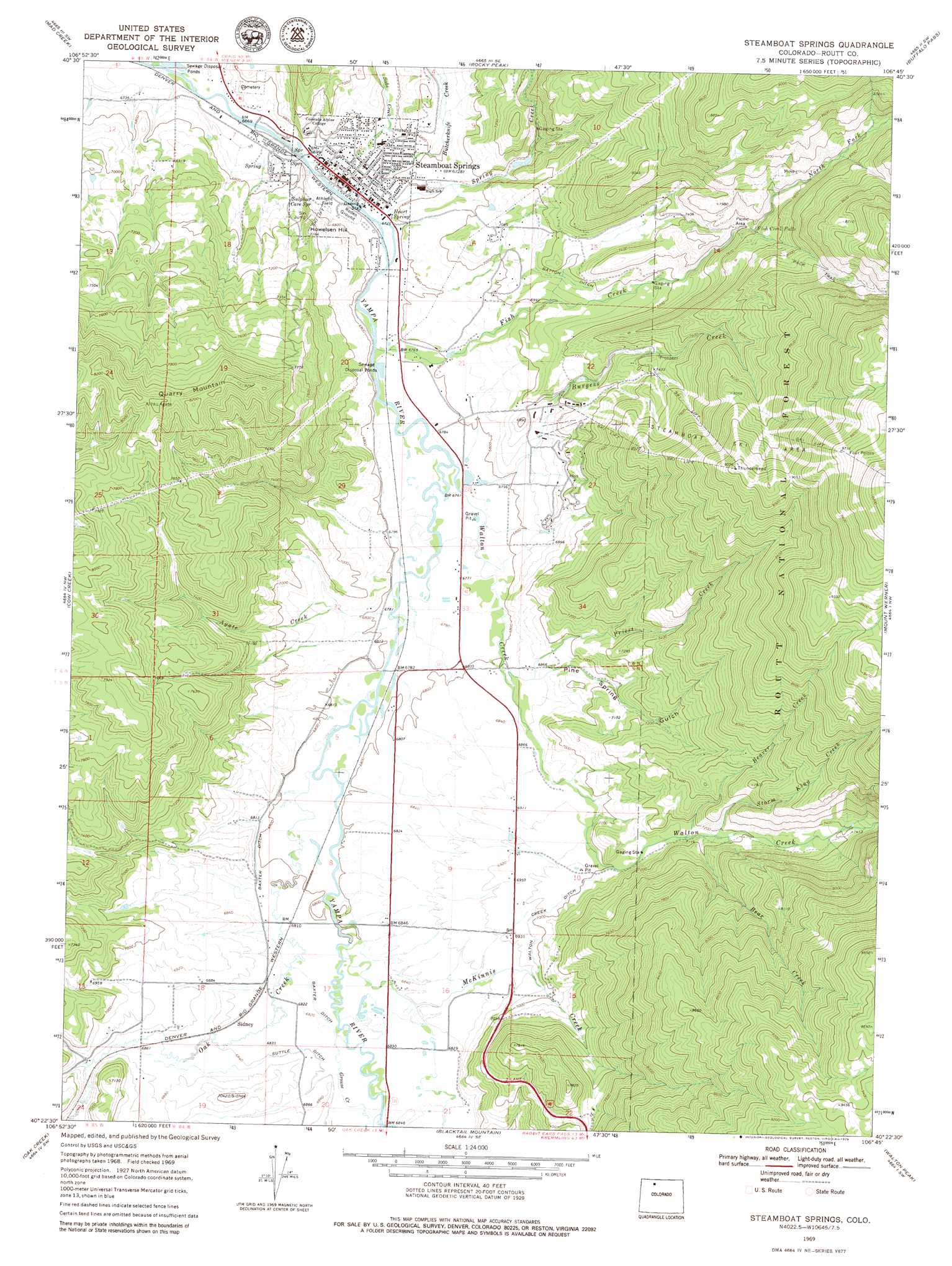
USGS Topo Quad 40106d7 - 1:24,000 scale
| Topo Map Name: | Steamboat Springs |
| USGS Topo Quad ID: | 40106d7 |
| Print Size: | ca. 21 1/4" wide x 27" high |
| Southeast Coordinates: | 40.375° N latitude / 106.75° W longitude |
| Map Center Coordinates: | 40.4375° N latitude / 106.8125° W longitude |
| U.S. State: | CO |
| Filename: | o40106d7.jpg |
| Download Map JPG Image: | Steamboat Springs topo map 1:24,000 scale |
| Map Type: | Topographic |
| Topo Series: | 7.5´ |
| Map Scale: | 1:24,000 |
| Source of Map Images: | United States Geological Survey (USGS) |
| Alternate Map Versions: |
Steamboat Springs CO 1969, updated 1972 Download PDF Buy paper map Steamboat Springs CO 1969, updated 1979 Download PDF Buy paper map Steamboat Springs CO 2011 Download PDF Buy paper map Steamboat Springs CO 2013 Download PDF Buy paper map Steamboat Springs CO 2016 Download PDF Buy paper map |
| FStopo: | US Forest Service topo Steamboat Springs is available: Download FStopo PDF Download FStopo TIF |
1:24,000 Topo Quads surrounding Steamboat Springs
Pilot Knob |
Clark |
Floyd Peak |
Mount Ethel |
Pitchpine Mountain |
Wolf Mountain |
Mad Creek |
Rocky Peak |
Buffalo Pass |
Teal Lake |
Milner |
Cow Creek |
Steamboat Springs |
Mount Werner |
Rabbit Ears Peak |
Rattlesnake Butte |
Oak Creek |
Blacktail Mountain |
Walton Peak |
Lake Agnes |
Sand Point |
Yampa |
Green Ridge |
Gore Mountain |
Tyler Mountain |
> Back to 40106a1 at 1:100,000 scale
> Back to 40106a1 at 1:250,000 scale
> Back to U.S. Topo Maps home
Steamboat Springs topo map: Gazetteer
Steamboat Springs: Canals
Batton Gulch elevation 2176m 7139′Baxter Ditch elevation 2079m 6820′
Suttle Ditch elevation 2086m 6843′
Walton Creek Ditch elevation 2130m 6988′
Steamboat Springs: Falls
Fish Creek Falls elevation 2316m 7598′Steamboat Springs: Mines
Fair-U Mine elevation 2429m 7969′Steamboat Springs: Populated Places
Steamboat Springs elevation 2052m 6732′Steamboat Springs: Springs
Heart Spring elevation 2060m 6758′Sulphur Cave Spring elevation 2059m 6755′
Steamboat Springs: Streams
Agate Creek elevation 2067m 6781′Bear Creek elevation 2176m 7139′
Beaver Creek elevation 2168m 7112′
Burgess Creek elevation 2069m 6788′
Fish Creek elevation 2054m 6738′
Grouse Creek elevation 2080m 6824′
McKinnis Creek elevation 2080m 6824′
McKinnis Creek elevation 2074m 6804′
North Fork Fish Creek elevation 2278m 7473′
Oak Creek elevation 2069m 6788′
Priest Creek elevation 2082m 6830′
Soda Creek elevation 2071m 6794′
Spring Creek elevation 2044m 6706′
Storm King Creek elevation 2180m 7152′
Walton Creek elevation 2059m 6755′
Steamboat Springs: Summits
Howelsen Hill elevation 2186m 7171′Quarry Mountain elevation 2515m 8251′
Steamboat Springs: Valleys
Pine Spring Gulch elevation 2084m 6837′Steamboat Springs digital topo map on disk
Buy this Steamboat Springs topo map showing relief, roads, GPS coordinates and other geographical features, as a high-resolution digital map file on DVD: