Lake Mountain Topo Map Utah
To zoom in, hover over the map of Lake Mountain
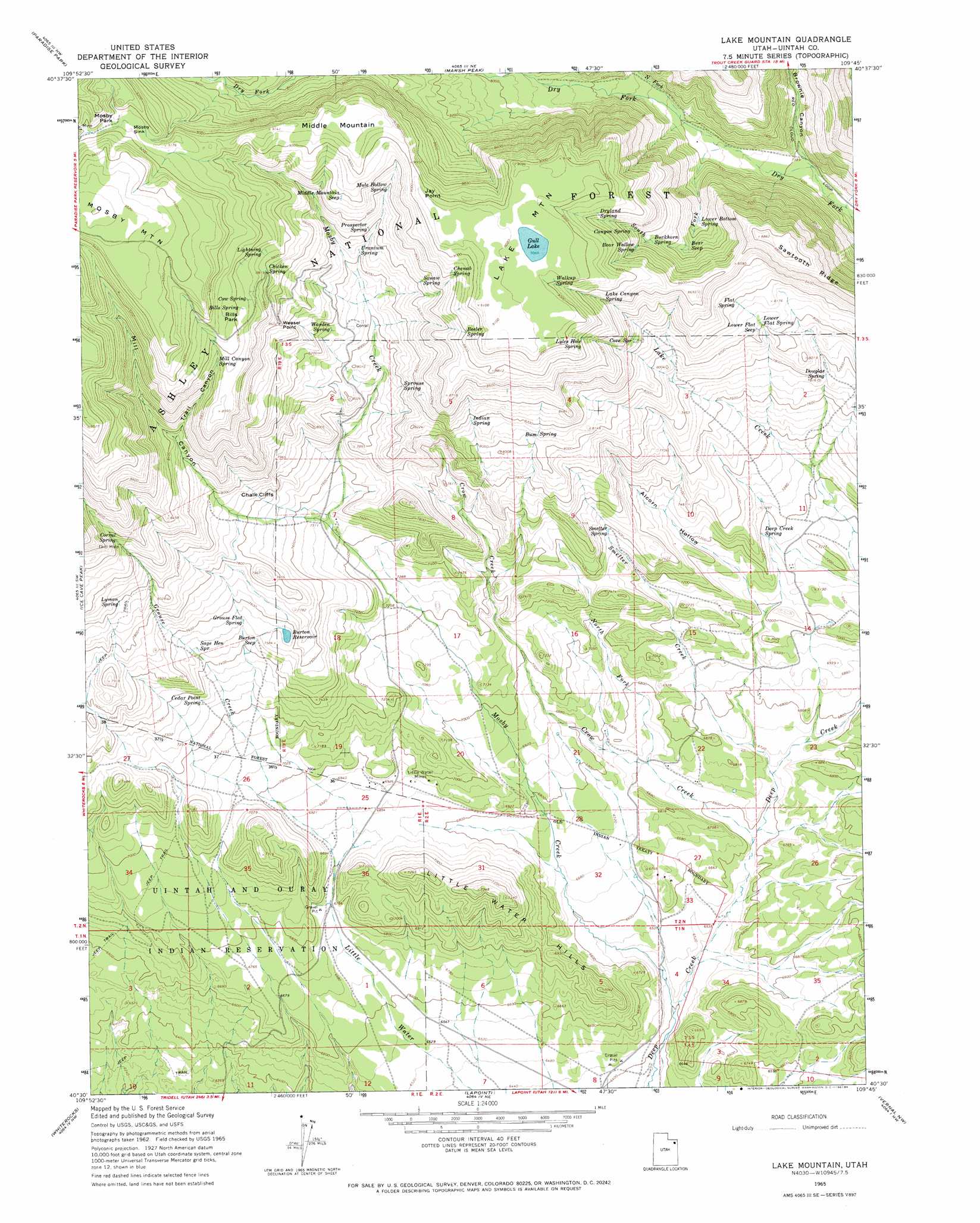
USGS Topo Quad 40109e7 - 1:24,000 scale
| Topo Map Name: | Lake Mountain |
| USGS Topo Quad ID: | 40109e7 |
| Print Size: | ca. 21 1/4" wide x 27" high |
| Southeast Coordinates: | 40.5° N latitude / 109.75° W longitude |
| Map Center Coordinates: | 40.5625° N latitude / 109.8125° W longitude |
| U.S. State: | UT |
| Filename: | o40109e7.jpg |
| Download Map JPG Image: | Lake Mountain topo map 1:24,000 scale |
| Map Type: | Topographic |
| Topo Series: | 7.5´ |
| Map Scale: | 1:24,000 |
| Source of Map Images: | United States Geological Survey (USGS) |
| Alternate Map Versions: |
Lake Mountain UT 1965, updated 1967 Download PDF Buy paper map Lake Mountain UT 1965, updated 1984 Download PDF Buy paper map Lake Mountain UT 1965, updated 1984 Download PDF Buy paper map Lake Mountain UT 1996, updated 1999 Download PDF Buy paper map Lake Mountain UT 2011 Download PDF Buy paper map Lake Mountain UT 2014 Download PDF Buy paper map |
| FStopo: | US Forest Service topo Lake Mountain is available: Download FStopo PDF Download FStopo TIF |
1:24,000 Topo Quads surrounding Lake Mountain
Chepeta Lake |
Whiterocks Lake |
Leidy Peak |
Elk Park |
East Park Reservoir |
Rasmussen Lakes |
Paradise Park |
Marsh Peak |
Taylor Mountain |
Dyer Mountain |
Pole Creek Cave |
Ice Cave Peak |
Lake Mountain |
Dry Fork |
Steinaker Reservoir |
Neola |
Whiterocks |
Lapoint |
Vernal Nw |
Vernal Ne |
Hancock Cove |
Roosevelt |
Fort Duchesne |
Vernal Sw |
Vernal Se |
> Back to 40109e1 at 1:100,000 scale
> Back to 40108a1 at 1:250,000 scale
> Back to U.S. Topo Maps home
Lake Mountain topo map: Gazetteer
Lake Mountain: Basins
Mosby Sink elevation 2801m 9189′Lake Mountain: Capes
Jay Point elevation 2753m 9032′Weasel Point elevation 2601m 8533′
Lake Mountain: Cliffs
Chalk Cliffs elevation 2380m 7808′Lake Mountain: Flats
Bills Park elevation 2738m 8982′Mosby Park elevation 2803m 9196′
Lake Mountain: Lakes
Gull Lake elevation 2765m 9071′Lake Mountain: Mines
Little Water Mines elevation 2107m 6912′Lake Mountain: Reservoirs
Burton Reservoir elevation 2304m 7559′Chokecherry Flat Reservoir elevation 2453m 8047′
Lower Grouse Reservoir elevation 2144m 7034′
Lake Mountain: Ridges
Sawtooth Ridge elevation 2624m 8608′Lake Mountain: Springs
Bear Seep elevation 2464m 8083′Bear Wallow Spring elevation 2557m 8389′
Beeler Spring elevation 2700m 8858′
Bills Spring elevation 2741m 8992′
Buckhorn Spring elevation 2531m 8303′
Bum Spring elevation 2444m 8018′
Burton Seep elevation 2283m 7490′
Canyon Spring elevation 2604m 8543′
Cedar Point Spring elevation 2232m 7322′
Chenab Spring elevation 2701m 8861′
Chicken Spring elevation 2677m 8782′
Corral Spring elevation 2539m 8330′
Cove Spring elevation 2523m 8277′
Cow Spring elevation 2727m 8946′
Deep Creek Spring elevation 2182m 7158′
Douglas Spring elevation 2363m 7752′
Dryland Spring elevation 2682m 8799′
Flat Spring elevation 2491m 8172′
Grouse Flat Spring elevation 2293m 7522′
Indian Spring elevation 2487m 8159′
Knoll Spring elevation 2354m 7723′
Lake Canyon Spring elevation 2628m 8622′
Lightning Spring elevation 2706m 8877′
Lower Bottom Spring elevation 2427m 7962′
Lower Flat Seep elevation 2444m 8018′
Lower Flat Spring elevation 2445m 8021′
Lyles Hole Spring elevation 2671m 8763′
Lyman Spring elevation 2441m 8008′
Middle Mountain Seep elevation 2687m 8815′
Mill Canyon Spring elevation 2708m 8884′
Mule Hollow Spring elevation 2646m 8681′
North Point Seep elevation 2681m 8795′
Prospector Spring elevation 2558m 8392′
Sage Hen Spring elevation 2280m 7480′
Smelter Spring elevation 2259m 7411′
Sprouse Spring elevation 2460m 8070′
Squaw Spring elevation 2601m 8533′
Uranium Spring elevation 2512m 8241′
Walkup Spring elevation 2747m 9012′
Warden Spring elevation 2481m 8139′
Lake Mountain: Streams
Crow Creek elevation 2002m 6568′Grouse Creek elevation 2126m 6975′
Lake Creek elevation 2205m 7234′
Mosby Creek elevation 1950m 6397′
North Fork Crow Creek elevation 2037m 6683′
North Fork Dry Fork elevation 2323m 7621′
Smelter Creek elevation 2023m 6637′
South Fork Dry Fork elevation 2301m 7549′
Lake Mountain: Summits
Lake Mountain elevation 2776m 9107′Little Water Hills elevation 2102m 6896′
Middle Mountain elevation 2788m 9146′
Lake Mountain: Valleys
Alcorn Hollow elevation 2128m 6981′Brownie Canyon elevation 2251m 7385′
Mill Canyon elevation 2315m 7595′
Trail Canyon elevation 2545m 8349′
Lake Mountain digital topo map on disk
Buy this Lake Mountain topo map showing relief, roads, GPS coordinates and other geographical features, as a high-resolution digital map file on DVD: