Ice Cave Peak Topo Map Utah
To zoom in, hover over the map of Ice Cave Peak
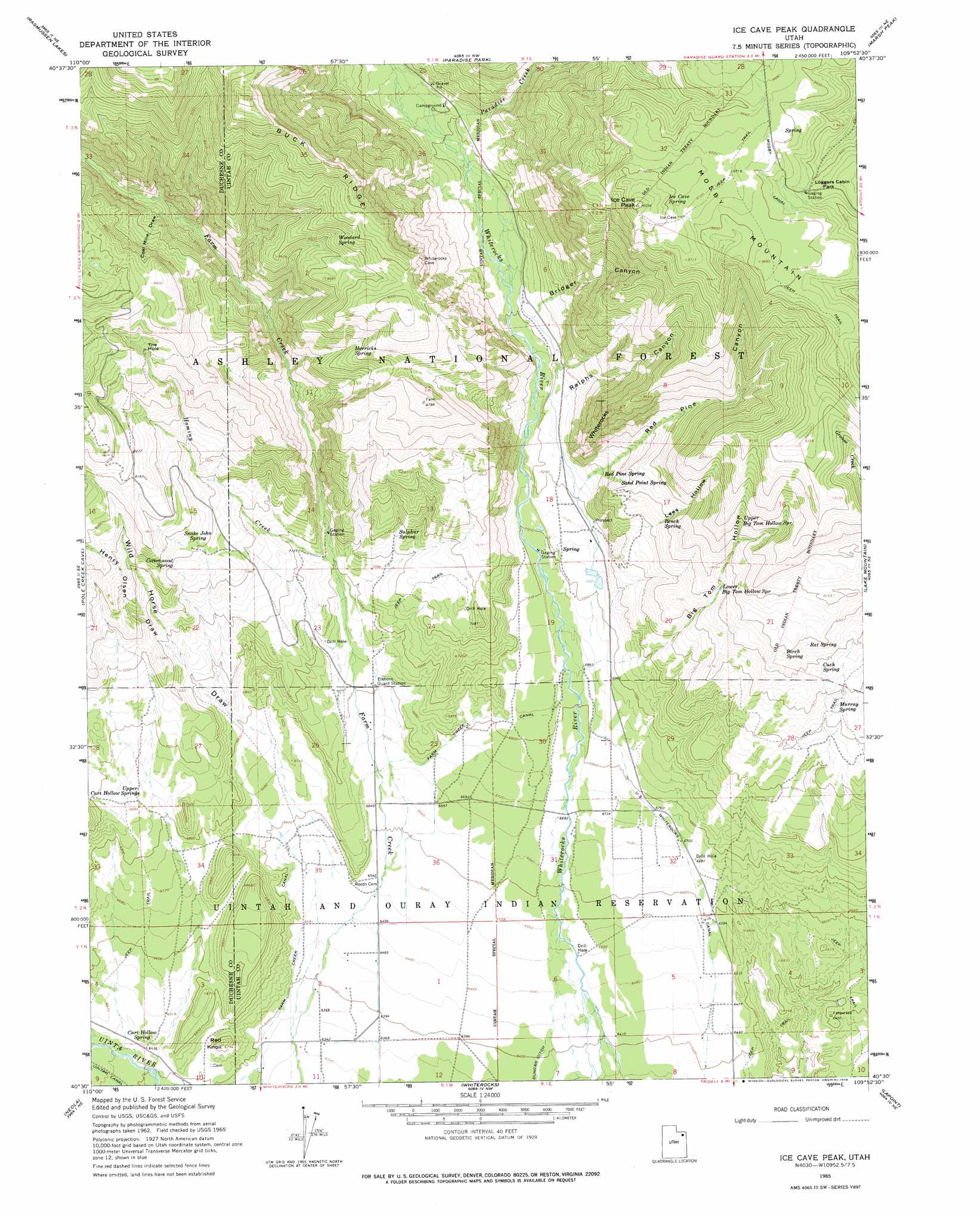
USGS Topo Quad 40109e8 - 1:24,000 scale
| Topo Map Name: | Ice Cave Peak |
| USGS Topo Quad ID: | 40109e8 |
| Print Size: | ca. 21 1/4" wide x 27" high |
| Southeast Coordinates: | 40.5° N latitude / 109.875° W longitude |
| Map Center Coordinates: | 40.5625° N latitude / 109.9375° W longitude |
| U.S. State: | UT |
| Filename: | o40109e8.jpg |
| Download Map JPG Image: | Ice Cave Peak topo map 1:24,000 scale |
| Map Type: | Topographic |
| Topo Series: | 7.5´ |
| Map Scale: | 1:24,000 |
| Source of Map Images: | United States Geological Survey (USGS) |
| Alternate Map Versions: |
Ice Cave Peak UT 1965, updated 1967 Download PDF Buy paper map Ice Cave Peak UT 1965, updated 1978 Download PDF Buy paper map Ice Cave Peak UT 1996, updated 2000 Download PDF Buy paper map Ice Cave Peak UT 2011 Download PDF Buy paper map Ice Cave Peak UT 2014 Download PDF Buy paper map |
| FStopo: | US Forest Service topo Ice Cave Peak is available: Download FStopo PDF Download FStopo TIF |
1:24,000 Topo Quads surrounding Ice Cave Peak
Fox Lake |
Chepeta Lake |
Whiterocks Lake |
Leidy Peak |
Elk Park |
Bollie Lake |
Rasmussen Lakes |
Paradise Park |
Marsh Peak |
Taylor Mountain |
Heller Lake |
Pole Creek Cave |
Ice Cave Peak |
Lake Mountain |
Dry Fork |
Neola Nw |
Neola |
Whiterocks |
Lapoint |
Vernal Nw |
Bluebell |
Hancock Cove |
Roosevelt |
Fort Duchesne |
Vernal Sw |
> Back to 40109e1 at 1:100,000 scale
> Back to 40108a1 at 1:250,000 scale
> Back to U.S. Topo Maps home
Ice Cave Peak topo map: Gazetteer
Ice Cave Peak: Areas
Bull Pasture elevation 2172m 7125′Ice Cave Peak: Basins
The Hole elevation 2571m 8435′Ice Cave Peak: Bridges
Farm Creek Bridge elevation 2074m 6804′Ice Cave Peak: Canals
Farm Creek Canal elevation 2026m 6646′Whiterocks Canal elevation 1992m 6535′
Ice Cave Peak: Flats
Loggers Cabin Park elevation 2873m 9425′Ice Cave Peak: Reservoirs
East Cart Hollow Reservoir elevation 2183m 7162′Ice Cave Peak: Ridges
Buck Ridge elevation 3003m 9852′Ice Cave Peak: Springs
Bench Spring elevation 2355m 7726′Birch Spring elevation 2432m 7979′
Cart Hollow Spring elevation 1972m 6469′
Cottonwood Spring elevation 2303m 7555′
Cuch Spring elevation 2363m 7752′
Horricks Spring elevation 2530m 8300′
Ice Cave Spring elevation 2984m 9790′
Lower Big Tom Hollow Spring elevation 2381m 7811′
Murray Spring elevation 2280m 7480′
Rat Spring elevation 2428m 7965′
Red Pine Spring elevation 2263m 7424′
Sand Point Spring elevation 2359m 7739′
Snake John Spring elevation 2326m 7631′
Sulphur Spring elevation 2244m 7362′
Upper Big Tom Hollow Spring elevation 2569m 8428′
Upper Cart Hollow Springs elevation 2115m 6938′
Woodard Spring elevation 2669m 8756′
Ice Cave Peak: Streams
Hominy Creek elevation 2135m 7004′Paradise Creek elevation 2266m 7434′
Ice Cave Peak: Summits
Ice Cave Peak elevation 3051m 10009′Mosby Mountain elevation 3051m 10009′
Red Knoll elevation 2041m 6696′
Whiterocks elevation 2647m 8684′
Ice Cave Peak: Valleys
Bathtub Trough elevation 2183m 7162′Big Tom Hollow elevation 2103m 6899′
Bridger Canyon elevation 2208m 7244′
Cart Hollow elevation 2109m 6919′
Coal Mine Draw elevation 2413m 7916′
Elkhorn Trough elevation 2074m 6804′
Henry Olsen Draw elevation 2159m 7083′
Lees Hollow elevation 2308m 7572′
Ralphs Canyon elevation 2267m 7437′
Red Pine Canyon elevation 2199m 7214′
Wild Horse Draw elevation 1988m 6522′
Ice Cave Peak digital topo map on disk
Buy this Ice Cave Peak topo map showing relief, roads, GPS coordinates and other geographical features, as a high-resolution digital map file on DVD: